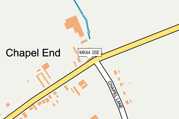
MK44 3SE lies on Cople Road in Cardington, Bedford. MK44 3SE is located in the Shortstown electoral ward, within the unitary authority of Bedford and the English Parliamentary constituency of North East Bedfordshire. The Sub Integrated Care Board (ICB) Location is NHS Bedfordshire, Luton and Milton Keynes ICB - M1J4Y and the police force is Bedfordshire. This postcode has been in use since January 1991.


GetTheData
Source: OS OpenMap – Local (Ordnance Survey)
Source: OS VectorMap District (Ordnance Survey)
Licence: Open Government Licence (requires attribution)
| Easting | 509305 |
| Northing | 248141 |
| Latitude | 52.120800 |
| Longitude | -0.404894 |
GetTheData
Source: Open Postcode Geo
Licence: Open Government Licence
| Street | Cople Road |
| Locality | Cardington |
| Town/City | Bedford |
| Country | England |
| Postcode District | MK44 |
➜ See where MK44 is on a map ➜ Where is Chapel End? | |
GetTheData
Source: Land Registry Price Paid Data
Licence: Open Government Licence
Elevation or altitude of MK44 3SE as distance above sea level:
| Metres | Feet | |
|---|---|---|
| Elevation | 30m | 98ft |
Elevation is measured from the approximate centre of the postcode, to the nearest point on an OS contour line from OS Terrain 50, which has contour spacing of ten vertical metres.
➜ How high above sea level am I? Find the elevation of your current position using your device's GPS.
GetTheData
Source: Open Postcode Elevation
Licence: Open Government Licence
| Ward | Shortstown |
| Constituency | North East Bedfordshire |
GetTheData
Source: ONS Postcode Database
Licence: Open Government Licence
| Chapel Lane (Cople Road) | Cardington | 6m |
| Chapel Lane (Cople Road) | Cardington | 16m |
| Cottage Farm Nursery (Cople Road) | Cardington | 304m |
| Cottage Farm Nursery (Cople Road) | Cardington | 381m |
| The Kings Arms (The Green) | Cardington | 660m |
| Bedford St Johns Station | 4.4km |
GetTheData
Source: NaPTAN
Licence: Open Government Licence
GetTheData
Source: ONS Postcode Database
Licence: Open Government Licence


➜ Get more ratings from the Food Standards Agency
GetTheData
Source: Food Standards Agency
Licence: FSA terms & conditions
| Last Collection | |||
|---|---|---|---|
| Location | Mon-Fri | Sat | Distance |
| Cople Road | 17:00 | 11:00 | 480m |
| Grange Road | 16:55 | 10:40 | 991m |
| Fraser Road | 18:30 | 12:00 | 1,218m |
GetTheData
Source: Dracos
Licence: Creative Commons Attribution-ShareAlike
The below table lists the International Territorial Level (ITL) codes (formerly Nomenclature of Territorial Units for Statistics (NUTS) codes) and Local Administrative Units (LAU) codes for MK44 3SE:
| ITL 1 Code | Name |
|---|---|
| TLH | East |
| ITL 2 Code | Name |
| TLH2 | Bedfordshire and Hertfordshire |
| ITL 3 Code | Name |
| TLH24 | Bedford |
| LAU 1 Code | Name |
| E06000055 | Bedford |
GetTheData
Source: ONS Postcode Directory
Licence: Open Government Licence
The below table lists the Census Output Area (OA), Lower Layer Super Output Area (LSOA), and Middle Layer Super Output Area (MSOA) for MK44 3SE:
| Code | Name | |
|---|---|---|
| OA | E00088286 | |
| LSOA | E01017486 | Bedford 019A |
| MSOA | E02003634 | Bedford 019 |
GetTheData
Source: ONS Postcode Directory
Licence: Open Government Licence
| MK44 3SJ | Cople Road | 44m |
| MK44 3SH | Cople Road | 301m |
| MK44 3SL | Howard Close | 376m |
| MK44 3SF | Yeomans Gate | 536m |
| MK44 3SX | Southill Road | 767m |
| MK44 3DD | Holm Oak Green | 806m |
| MK44 3TT | Grange Lane | 920m |
| MK44 3TU | Northill Road | 1104m |
| MK44 3UE | Woodlands Close | 1171m |
| MK44 3TH | Willington Road | 1198m |
GetTheData
Source: Open Postcode Geo; Land Registry Price Paid Data
Licence: Open Government Licence