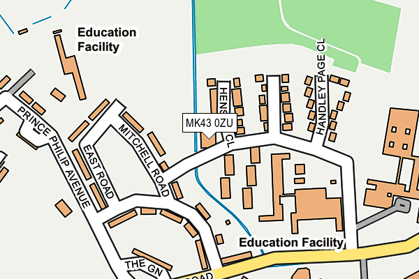
MK43 0ZU is located in the Cranfield & Marston Moretaine electoral ward, within the unitary authority of Central Bedfordshire and the English Parliamentary constituency of Mid Bedfordshire. The Sub Integrated Care Board (ICB) Location is NHS Bedfordshire, Luton and Milton Keynes ICB - M1J4Y and the police force is Bedfordshire. This postcode has been in use since May 2016.


GetTheData
Source: OS OpenMap – Local (Ordnance Survey)
Source: OS VectorMap District (Ordnance Survey)
Licence: Open Government Licence (requires attribution)
| Easting | 494150 |
| Northing | 242932 |
| Latitude | 52.076755 |
| Longitude | -0.627632 |
GetTheData
Source: Open Postcode Geo
Licence: Open Government Licence
| Country | England |
| Postcode District | MK43 |
➜ See where MK43 is on a map ➜ Where is Wharley End? | |
GetTheData
Source: Land Registry Price Paid Data
Licence: Open Government Licence
Elevation or altitude of MK43 0ZU as distance above sea level:
| Metres | Feet | |
|---|---|---|
| Elevation | 100m | 328ft |
Elevation is measured from the approximate centre of the postcode, to the nearest point on an OS contour line from OS Terrain 50, which has contour spacing of ten vertical metres.
➜ How high above sea level am I? Find the elevation of your current position using your device's GPS.
GetTheData
Source: Open Postcode Elevation
Licence: Open Government Licence
| Ward | Cranfield & Marston Moretaine |
| Constituency | Mid Bedfordshire |
GetTheData
Source: ONS Postcode Database
Licence: Open Government Licence
| Cranfield University Main Gate (The Green) | Wharley End | 248m |
| Cranfield University Main Gate (The Green) | Wharley End | 254m |
| University Way | Cranfield | 890m |
| University Way | Cranfield | 895m |
| Cranfield Innovation Centre (University Way) | Wharley End | 1,104m |
| Lidlington Station | 6.1km |
GetTheData
Source: NaPTAN
Licence: Open Government Licence
GetTheData
Source: ONS Postcode Database
Licence: Open Government Licence


➜ Get more ratings from the Food Standards Agency
GetTheData
Source: Food Standards Agency
Licence: FSA terms & conditions
| Last Collection | |||
|---|---|---|---|
| Location | Mon-Fri | Sat | Distance |
| Post Office College Road | 17:30 | 10:30 | 211m |
| High Street, West End | 14:45 | 08:05 | 1,532m |
| High Street | 16:50 | 09:15 | 1,587m |
GetTheData
Source: Dracos
Licence: Creative Commons Attribution-ShareAlike
The below table lists the International Territorial Level (ITL) codes (formerly Nomenclature of Territorial Units for Statistics (NUTS) codes) and Local Administrative Units (LAU) codes for MK43 0ZU:
| ITL 1 Code | Name |
|---|---|
| TLH | East |
| ITL 2 Code | Name |
| TLH2 | Bedfordshire and Hertfordshire |
| ITL 3 Code | Name |
| TLH25 | Central Bedfordshire |
| LAU 1 Code | Name |
| E06000056 | Central Bedfordshire |
GetTheData
Source: ONS Postcode Directory
Licence: Open Government Licence
The below table lists the Census Output Area (OA), Lower Layer Super Output Area (LSOA), and Middle Layer Super Output Area (MSOA) for MK43 0ZU:
| Code | Name | |
|---|---|---|
| OA | E00087859 | |
| LSOA | E01033194 | Central Bedfordshire 007G |
| MSOA | E02003605 | Central Bedfordshire 007 |
GetTheData
Source: ONS Postcode Directory
Licence: Open Government Licence
| MK43 0DA | Merchant Lane | 1349m |
| MK43 0HT | Lincroft | 1393m |
| MK43 0HS | Lincroft | 1398m |
| MK43 0BZ | Simdims | 1438m |
| MK43 0HU | Orchard Way | 1456m |
| MK43 0BY | Maltings Close | 1460m |
| MK43 0HX | Orchard Close | 1480m |
| MK43 0DJ | Townsend Close | 1481m |
| MK43 0DL | Folly Farm | 1496m |
| MK43 0GJ | Badgers Close | 1511m |
GetTheData
Source: Open Postcode Geo; Land Registry Price Paid Data
Licence: Open Government Licence