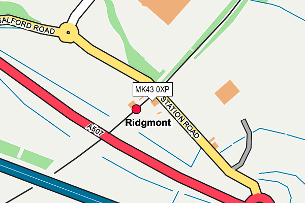
MK43 0XP is located in the Cranfield & Marston Moretaine electoral ward, within the unitary authority of Central Bedfordshire and the English Parliamentary constituency of Mid Bedfordshire. The Sub Integrated Care Board (ICB) Location is NHS Bedfordshire, Luton and Milton Keynes ICB - M1J4Y and the police force is Bedfordshire. This postcode has been in use since January 1980.


GetTheData
Source: OS OpenMap – Local (Ordnance Survey)
Source: OS VectorMap District (Ordnance Survey)
Licence: Open Government Licence (requires attribution)
| Easting | 496528 |
| Northing | 237383 |
| Latitude | 52.026473 |
| Longitude | -0.594511 |
GetTheData
Source: Open Postcode Geo
Licence: Open Government Licence
| Country | England |
| Postcode District | MK43 |
➜ See where MK43 is on a map | |
GetTheData
Source: Land Registry Price Paid Data
Licence: Open Government Licence
Elevation or altitude of MK43 0XP as distance above sea level:
| Metres | Feet | |
|---|---|---|
| Elevation | 80m | 262ft |
Elevation is measured from the approximate centre of the postcode, to the nearest point on an OS contour line from OS Terrain 50, which has contour spacing of ten vertical metres.
➜ How high above sea level am I? Find the elevation of your current position using your device's GPS.
GetTheData
Source: Open Postcode Elevation
Licence: Open Government Licence
| Ward | Cranfield & Marston Moretaine |
| Constituency | Mid Bedfordshire |
GetTheData
Source: ONS Postcode Database
Licence: Open Government Licence
| Ridgmont Railway Station (Station Road) | Brogborough | 13m |
| Ridgmont Railway Station (Station Road) | Brogborough | 34m |
| Shops (Bedford Road) | Brogborough | 877m |
| Shops (Bedford Road) | Brogborough | 912m |
| Lydds Hill (Station Road) | Ridgmont | 1,345m |
| Ridgmont Station | 0km |
| Aspley Guise Station | 2.7km |
| Lidlington Station | 3km |
GetTheData
Source: NaPTAN
Licence: Open Government Licence
GetTheData
Source: ONS Postcode Database
Licence: Open Government Licence


➜ Get more ratings from the Food Standards Agency
GetTheData
Source: Food Standards Agency
Licence: FSA terms & conditions
| Last Collection | |||
|---|---|---|---|
| Location | Mon-Fri | Sat | Distance |
| Station House | 15:20 | 09:30 | 15m |
| Post Office Bedford Road | 16:00 | 09:00 | 884m |
| Church End | 16:45 | 08:00 | 1,554m |
GetTheData
Source: Dracos
Licence: Creative Commons Attribution-ShareAlike
The below table lists the International Territorial Level (ITL) codes (formerly Nomenclature of Territorial Units for Statistics (NUTS) codes) and Local Administrative Units (LAU) codes for MK43 0XP:
| ITL 1 Code | Name |
|---|---|
| TLH | East |
| ITL 2 Code | Name |
| TLH2 | Bedfordshire and Hertfordshire |
| ITL 3 Code | Name |
| TLH25 | Central Bedfordshire |
| LAU 1 Code | Name |
| E06000056 | Central Bedfordshire |
GetTheData
Source: ONS Postcode Directory
Licence: Open Government Licence
The below table lists the Census Output Area (OA), Lower Layer Super Output Area (LSOA), and Middle Layer Super Output Area (MSOA) for MK43 0XP:
| Code | Name | |
|---|---|---|
| OA | E00087847 | |
| LSOA | E01033194 | Central Bedfordshire 007G |
| MSOA | E02003605 | Central Bedfordshire 007 |
GetTheData
Source: ONS Postcode Directory
Licence: Open Government Licence
| MK43 0XZ | Highfield Crescent | 831m |
| MK43 0YA | Ridgway Road | 861m |
| MK43 0SW | Bowling Close | 876m |
| MK43 0XY | Bedford Road | 882m |
| MK43 0YB | Hill Crescent | 903m |
| MK43 0UT | Bedford Road | 909m |
| MK43 0UJ | Station Road | 1272m |
| MK43 0XF | Mill Road | 1307m |
| MK43 0UF | Lydds Hill | 1318m |
| MK43 0UH | Station Road | 1415m |
GetTheData
Source: Open Postcode Geo; Land Registry Price Paid Data
Licence: Open Government Licence