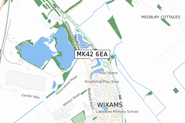
MK42 6EA is located in the Wixams & Wilstead electoral ward, within the unitary authority of Bedford and the English Parliamentary constituency of Mid Bedfordshire. The Sub Integrated Care Board (ICB) Location is NHS Bedfordshire, Luton and Milton Keynes ICB - M1J4Y and the police force is Bedfordshire. This postcode has been in use since January 2018.


GetTheData
Source: OS Open Zoomstack (Ordnance Survey)
Licence: Open Government Licence (requires attribution)
Attribution: Contains OS data © Crown copyright and database right 2025
Source: Open Postcode Geo
Licence: Open Government Licence (requires attribution)
Attribution: Contains OS data © Crown copyright and database right 2025; Contains Royal Mail data © Royal Mail copyright and database right 2025; Source: Office for National Statistics licensed under the Open Government Licence v.3.0
| Easting | 505314 |
| Northing | 245439 |
| Latitude | 52.097290 |
| Longitude | -0.463998 |
GetTheData
Source: Open Postcode Geo
Licence: Open Government Licence
| Country | England |
| Postcode District | MK42 |
➜ See where MK42 is on a map | |
GetTheData
Source: Land Registry Price Paid Data
Licence: Open Government Licence
| Ward | Wixams & Wilstead |
| Constituency | Mid Bedfordshire |
GetTheData
Source: ONS Postcode Database
Licence: Open Government Licence
| Wilstead Industrial Park (Bedford Road) | Wixams | 306m |
| Wilstead Industrial Park (Bedford Road) | Wixams | 332m |
| Dove Lane (Green Lane) | Wixams | 795m |
| Dove Lane (Green Lane) | Wixams | 814m |
| Moss Lane (Wilstead Road) | Elstow | 1,174m |
| Kempston Hardwick Station | 2.8km |
| Bedford St Johns Station | 3.6km |
| Bedford Station | 4.5km |
GetTheData
Source: NaPTAN
Licence: Open Government Licence
| Percentage of properties with Next Generation Access | 100.0% |
| Percentage of properties with Superfast Broadband | 100.0% |
| Percentage of properties with Ultrafast Broadband | 100.0% |
| Percentage of properties with Full Fibre Broadband | 100.0% |
Superfast Broadband is between 30Mbps and 300Mbps
Ultrafast Broadband is > 300Mbps
| Percentage of properties unable to receive 2Mbps | 0.0% |
| Percentage of properties unable to receive 5Mbps | 0.0% |
| Percentage of properties unable to receive 10Mbps | 0.0% |
| Percentage of properties unable to receive 30Mbps | 0.0% |
GetTheData
Source: Ofcom
Licence: Ofcom Terms of Use (requires attribution)
GetTheData
Source: ONS Postcode Database
Licence: Open Government Licence


➜ Get more ratings from the Food Standards Agency
GetTheData
Source: Food Standards Agency
Licence: FSA terms & conditions
| Last Collection | |||
|---|---|---|---|
| Location | Mon-Fri | Sat | Distance |
| Dane Lane Loop | 17:00 | 11:45 | 1,017m |
| Peartree View | 17:30 | 10:30 | 1,227m |
| Post Office High Street | 17:30 | 10:30 | 2,154m |
GetTheData
Source: Dracos
Licence: Creative Commons Attribution-ShareAlike
The below table lists the International Territorial Level (ITL) codes (formerly Nomenclature of Territorial Units for Statistics (NUTS) codes) and Local Administrative Units (LAU) codes for MK42 6EA:
| ITL 1 Code | Name |
|---|---|
| TLH | East |
| ITL 2 Code | Name |
| TLH2 | Bedfordshire and Hertfordshire |
| ITL 3 Code | Name |
| TLH24 | Bedford |
| LAU 1 Code | Name |
| E06000055 | Bedford |
GetTheData
Source: ONS Postcode Directory
Licence: Open Government Licence
The below table lists the Census Output Area (OA), Lower Layer Super Output Area (LSOA), and Middle Layer Super Output Area (MSOA) for MK42 6EA:
| Code | Name | |
|---|---|---|
| OA | E00088584 | |
| LSOA | E01017550 | Bedford 019E |
| MSOA | E02003634 | Bedford 019 |
GetTheData
Source: ONS Postcode Directory
Licence: Open Government Licence
| MK42 6BF | Bluewater Quay | 196m |
| MK42 6DE | Little Causeway | 199m |
| MK42 6DF | Millbrook Close | 205m |
| MK42 6DG | Lakeside Way | 267m |
| MK42 6AF | Mallard Court | 295m |
| MK42 6BJ | Moorland Close | 296m |
| MK42 6DQ | Greenside Close | 334m |
| MK42 6BL | Fieldfare View | 362m |
| MK42 6AX | Brooklands Avenue | 382m |
| MK42 6AG | Peacock Gardens | 384m |
GetTheData
Source: Open Postcode Geo; Land Registry Price Paid Data
Licence: Open Government Licence