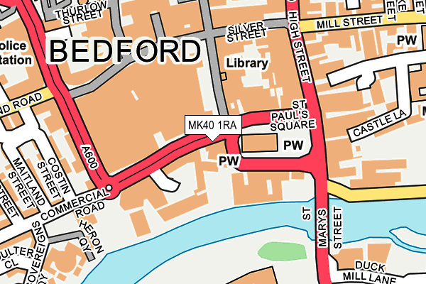
MK40 1RA is located in the Greyfriars electoral ward, within the unitary authority of Bedford and the English Parliamentary constituency of Bedford. The Sub Integrated Care Board (ICB) Location is NHS Bedfordshire, Luton and Milton Keynes ICB - M1J4Y and the police force is Bedfordshire. This postcode has been in use since June 1999.


GetTheData
Source: OS OpenMap – Local (Ordnance Survey)
Source: OS VectorMap District (Ordnance Survey)
Licence: Open Government Licence (requires attribution)
| Easting | 504922 |
| Northing | 249680 |
| Latitude | 52.135468 |
| Longitude | -0.468435 |
GetTheData
Source: Open Postcode Geo
Licence: Open Government Licence
| Country | England |
| Postcode District | MK40 |
➜ See where MK40 is on a map ➜ Where is Bedford? | |
GetTheData
Source: Land Registry Price Paid Data
Licence: Open Government Licence
Elevation or altitude of MK40 1RA as distance above sea level:
| Metres | Feet | |
|---|---|---|
| Elevation | 30m | 98ft |
Elevation is measured from the approximate centre of the postcode, to the nearest point on an OS contour line from OS Terrain 50, which has contour spacing of ten vertical metres.
➜ How high above sea level am I? Find the elevation of your current position using your device's GPS.
GetTheData
Source: Open Postcode Elevation
Licence: Open Government Licence
| Ward | Greyfriars |
| Constituency | Bedford |
GetTheData
Source: ONS Postcode Database
Licence: Open Government Licence
| St Paul's Square | Bedford | 51m |
| St Paul's Square | Bedford | 69m |
| Pilgrims House (Horne Lane) | Bedford | 73m |
| St Paul's Square | Bedford | 87m |
| St Paul's Square | Bedford | 102m |
| Bedford St Johns Station | 0.7km |
| Bedford Station | 0.8km |
| Kempston Hardwick Station | 5.4km |
GetTheData
Source: NaPTAN
Licence: Open Government Licence
GetTheData
Source: ONS Postcode Database
Licence: Open Government Licence


➜ Get more ratings from the Food Standards Agency
GetTheData
Source: Food Standards Agency
Licence: FSA terms & conditions
| Last Collection | |||
|---|---|---|---|
| Location | Mon-Fri | Sat | Distance |
| St Pauls Square | 19:15 | 12:45 | 50m |
| Harpur Street | 19:05 | 12:30 | 135m |
| High Street | 19:10 | 12:35 | 231m |
GetTheData
Source: Dracos
Licence: Creative Commons Attribution-ShareAlike
| Risk of MK40 1RA flooding from rivers and sea | Low |
| ➜ MK40 1RA flood map | |
GetTheData
Source: Open Flood Risk by Postcode
Licence: Open Government Licence
The below table lists the International Territorial Level (ITL) codes (formerly Nomenclature of Territorial Units for Statistics (NUTS) codes) and Local Administrative Units (LAU) codes for MK40 1RA:
| ITL 1 Code | Name |
|---|---|
| TLH | East |
| ITL 2 Code | Name |
| TLH2 | Bedfordshire and Hertfordshire |
| ITL 3 Code | Name |
| TLH24 | Bedford |
| LAU 1 Code | Name |
| E06000055 | Bedford |
GetTheData
Source: ONS Postcode Directory
Licence: Open Government Licence
The below table lists the Census Output Area (OA), Lower Layer Super Output Area (LSOA), and Middle Layer Super Output Area (MSOA) for MK40 1RA:
| Code | Name | |
|---|---|---|
| OA | E00173771 | |
| LSOA | E01017466 | Bedford 012A |
| MSOA | E02003627 | Bedford 012 |
GetTheData
Source: ONS Postcode Directory
Licence: Open Government Licence
| MK40 1SL | St Pauls Square | 112m |
| MK40 1SP | High Street | 146m |
| MK40 1RY | High Street | 161m |
| MK40 1PL | Midland Road | 164m |
| MK40 1RN | High Street | 168m |
| MK40 1RZ | High Street | 177m |
| MK40 1SY | Silver Street | 188m |
| MK40 3UT | Castle Mews | 188m |
| MK40 1PX | River Street | 195m |
| MK40 3US | Castle Lane | 211m |
GetTheData
Source: Open Postcode Geo; Land Registry Price Paid Data
Licence: Open Government Licence