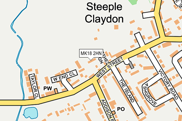
MK18 2HN lies on Whites Close in Steeple Claydon, Buckingham. MK18 2HN is located in the Grendon Underwood electoral ward, within the unitary authority of Buckinghamshire and the English Parliamentary constituency of Buckingham. The Sub Integrated Care Board (ICB) Location is NHS Buckinghamshire, Oxfordshire and Berkshire West ICB - 14Y and the police force is Thames Valley. This postcode has been in use since December 1997.


GetTheData
Source: OS OpenMap – Local (Ordnance Survey)
Source: OS VectorMap District (Ordnance Survey)
Licence: Open Government Licence (requires attribution)
| Easting | 469509 |
| Northing | 227007 |
| Latitude | 51.937238 |
| Longitude | -0.990334 |
GetTheData
Source: Open Postcode Geo
Licence: Open Government Licence
| Street | Whites Close |
| Locality | Steeple Claydon |
| Town/City | Buckingham |
| Country | England |
| Postcode District | MK18 |
➜ See where MK18 is on a map ➜ Where is Steeple Claydon? | |
GetTheData
Source: Land Registry Price Paid Data
Licence: Open Government Licence
Elevation or altitude of MK18 2HN as distance above sea level:
| Metres | Feet | |
|---|---|---|
| Elevation | 90m | 295ft |
Elevation is measured from the approximate centre of the postcode, to the nearest point on an OS contour line from OS Terrain 50, which has contour spacing of ten vertical metres.
➜ How high above sea level am I? Find the elevation of your current position using your device's GPS.
GetTheData
Source: Open Postcode Elevation
Licence: Open Government Licence
| Ward | Grendon Underwood |
| Constituency | Buckingham |
GetTheData
Source: ONS Postcode Database
Licence: Open Government Licence
2020 27 AUG £310,000 |
2, WHITES CLOSE, STEEPLE CLAYDON, BUCKINGHAM, MK18 2HN 2009 30 JUL £204,000 |
2, WHITES CLOSE, STEEPLE CLAYDON, BUCKINGHAM, MK18 2HN 2005 25 NOV £215,000 |
5, WHITES CLOSE, STEEPLE CLAYDON, BUCKINGHAM, MK18 2HN 2004 16 JUL £184,950 |
1, WHITES CLOSE, STEEPLE CLAYDON, BUCKINGHAM, MK18 2HN 1998 27 NOV £123,000 |
2, WHITES CLOSE, STEEPLE CLAYDON, BUCKINGHAM, MK18 2HN 1998 24 APR £85,950 |
5, WHITES CLOSE, STEEPLE CLAYDON, BUCKINGHAM, MK18 2HN 1998 27 FEB £79,500 |
1998 5 FEB £81,500 |
1, WHITES CLOSE, STEEPLE CLAYDON, BUCKINGHAM, MK18 2HN 1997 23 DEC £109,000 |
➜ Steeple Claydon house prices
GetTheData
Source: HM Land Registry Price Paid Data
Licence: Contains HM Land Registry data © Crown copyright and database right 2025. This data is licensed under the Open Government Licence v3.0.
| West Street | Steeple Claydon | 67m |
| West End (West Street) | Steeple Claydon | 154m |
| West End (West Street) | Steeple Claydon | 164m |
| The Fountain Ph (West Street) | Steeple Claydon | 220m |
| The Fountain Ph (West Street) | Steeple Claydon | 231m |
GetTheData
Source: NaPTAN
Licence: Open Government Licence
| Percentage of properties with Next Generation Access | 100.0% |
| Percentage of properties with Superfast Broadband | 100.0% |
| Percentage of properties with Ultrafast Broadband | 0.0% |
| Percentage of properties with Full Fibre Broadband | 0.0% |
Superfast Broadband is between 30Mbps and 300Mbps
Ultrafast Broadband is > 300Mbps
| Median download speed | 67.0Mbps |
| Average download speed | 58.8Mbps |
| Maximum download speed | 78.12Mbps |
| Median upload speed | 19.5Mbps |
| Average upload speed | 14.1Mbps |
| Maximum upload speed | 20.00Mbps |
| Percentage of properties unable to receive 2Mbps | 0.0% |
| Percentage of properties unable to receive 5Mbps | 0.0% |
| Percentage of properties unable to receive 10Mbps | 0.0% |
| Percentage of properties unable to receive 30Mbps | 0.0% |
GetTheData
Source: Ofcom
Licence: Ofcom Terms of Use (requires attribution)
GetTheData
Source: ONS Postcode Database
Licence: Open Government Licence


➜ Get more ratings from the Food Standards Agency
GetTheData
Source: Food Standards Agency
Licence: FSA terms & conditions
| Last Collection | |||
|---|---|---|---|
| Location | Mon-Fri | Sat | Distance |
| Post Office Addison Road | 16:15 | 07:30 | 179m |
| West End | 16:15 | 09:30 | 227m |
| Buckingham Road | 16:30 | 09:00 | 820m |
GetTheData
Source: Dracos
Licence: Creative Commons Attribution-ShareAlike
The below table lists the International Territorial Level (ITL) codes (formerly Nomenclature of Territorial Units for Statistics (NUTS) codes) and Local Administrative Units (LAU) codes for MK18 2HN:
| ITL 1 Code | Name |
|---|---|
| TLJ | South East (England) |
| ITL 2 Code | Name |
| TLJ1 | Berkshire, Buckinghamshire and Oxfordshire |
| ITL 3 Code | Name |
| TLJ13 | Buckinghamshire |
| LAU 1 Code | Name |
| E06000060 | Buckinghamshire |
GetTheData
Source: ONS Postcode Directory
Licence: Open Government Licence
The below table lists the Census Output Area (OA), Lower Layer Super Output Area (LSOA), and Middle Layer Super Output Area (MSOA) for MK18 2HN:
| Code | Name | |
|---|---|---|
| OA | E00089382 | |
| LSOA | E01017714 | Aylesbury Vale 004D |
| MSOA | E02003655 | Aylesbury Vale 004 |
GetTheData
Source: ONS Postcode Directory
Licence: Open Government Licence
| MK18 2FU | The Green | 42m |
| MK18 2LN | West End Close | 116m |
| MK18 2NS | West Street | 130m |
| MK18 2NT | West Street | 148m |
| MK18 2HJ | Shinfields Close | 151m |
| MK18 2NX | Greenwood Place | 159m |
| MK18 2NU | The Island | 163m |
| MK18 2NP | Addison Road | 181m |
| MK18 2LW | Ashgrove | 209m |
| MK18 2NW | Ashgrove | 226m |
GetTheData
Source: Open Postcode Geo; Land Registry Price Paid Data
Licence: Open Government Licence