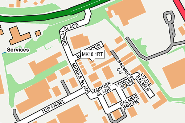
MK18 1RT lies on Ballmoor in Buckingham Industrial Estate, Buckingham. MK18 1RT is located in the Buckingham West electoral ward, within the unitary authority of Buckinghamshire and the English Parliamentary constituency of Buckingham. The Sub Integrated Care Board (ICB) Location is NHS Buckinghamshire, Oxfordshire and Berkshire West ICB - 14Y and the police force is Thames Valley. This postcode has been in use since April 1987.


GetTheData
Source: OS OpenMap – Local (Ordnance Survey)
Source: OS VectorMap District (Ordnance Survey)
Licence: Open Government Licence (requires attribution)
| Easting | 469926 |
| Northing | 232647 |
| Latitude | 51.987895 |
| Longitude | -0.983104 |
GetTheData
Source: Open Postcode Geo
Licence: Open Government Licence
| Street | Ballmoor |
| Locality | Buckingham Industrial Estate |
| Town/City | Buckingham |
| Country | England |
| Postcode District | MK18 |
➜ See where MK18 is on a map ➜ Where is Buckingham? | |
GetTheData
Source: Land Registry Price Paid Data
Licence: Open Government Licence
Elevation or altitude of MK18 1RT as distance above sea level:
| Metres | Feet | |
|---|---|---|
| Elevation | 100m | 328ft |
Elevation is measured from the approximate centre of the postcode, to the nearest point on an OS contour line from OS Terrain 50, which has contour spacing of ten vertical metres.
➜ How high above sea level am I? Find the elevation of your current position using your device's GPS.
GetTheData
Source: Open Postcode Elevation
Licence: Open Government Licence
| Ward | Buckingham West |
| Constituency | Buckingham |
GetTheData
Source: ONS Postcode Database
Licence: Open Government Licence
4, BALLMOOR, BUCKINGHAM INDUSTRIAL ESTATE, BUCKINGHAM, MK18 1RT 2004 31 AUG £197,000 |
4, BALLMOOR, BUCKINGHAM INDUSTRIAL ESTATE, BUCKINGHAM, MK18 1RT 2002 11 SEP £59,000 |
GetTheData
Source: HM Land Registry Price Paid Data
Licence: Contains HM Land Registry data © Crown copyright and database right 2025. This data is licensed under the Open Government Licence v3.0.
| Wipac Works (Tesco Entrance Road) | Buckingham | 217m |
| Tesco (Tesco Entrance Road) | Buckingham | 299m |
| Tesco (London Road) | Buckingham | 325m |
| Tesco (London Road) | Buckingham | 348m |
| London Road | Buckingham | 461m |
GetTheData
Source: NaPTAN
Licence: Open Government Licence
Estimated total energy consumption in MK18 1RT by fuel type, 2015.
| Consumption (kWh) | 63,866 |
|---|---|
| Meter count | 6 |
| Mean (kWh/meter) | 10,644 |
| Median (kWh/meter) | 11,974 |
GetTheData
Source: Postcode level gas estimates: 2015 (experimental)
Source: Postcode level electricity estimates: 2015 (experimental)
Licence: Open Government Licence
GetTheData
Source: ONS Postcode Database
Licence: Open Government Licence


➜ Get more ratings from the Food Standards Agency
GetTheData
Source: Food Standards Agency
Licence: FSA terms & conditions
| Last Collection | |||
|---|---|---|---|
| Location | Mon-Fri | Sat | Distance |
| Industrial Park | 18:30 | 09:00 | 49m |
| Middle Slade | 18:30 | 66m | |
| Medway | 17:30 | 12:00 | 343m |
GetTheData
Source: Dracos
Licence: Creative Commons Attribution-ShareAlike
The below table lists the International Territorial Level (ITL) codes (formerly Nomenclature of Territorial Units for Statistics (NUTS) codes) and Local Administrative Units (LAU) codes for MK18 1RT:
| ITL 1 Code | Name |
|---|---|
| TLJ | South East (England) |
| ITL 2 Code | Name |
| TLJ1 | Berkshire, Buckinghamshire and Oxfordshire |
| ITL 3 Code | Name |
| TLJ13 | Buckinghamshire |
| LAU 1 Code | Name |
| E06000060 | Buckinghamshire |
GetTheData
Source: ONS Postcode Directory
Licence: Open Government Licence
The below table lists the Census Output Area (OA), Lower Layer Super Output Area (LSOA), and Middle Layer Super Output Area (MSOA) for MK18 1RT:
| Code | Name | |
|---|---|---|
| OA | E00169106 | |
| LSOA | E01017650 | Aylesbury Vale 001C |
| MSOA | E02003652 | Aylesbury Vale 001 |
GetTheData
Source: ONS Postcode Directory
Licence: Open Government Licence
| MK18 1WA | Middle Slade | 98m |
| MK18 1XJ | Homestall | 149m |
| MK18 1UH | Homeground | 160m |
| MK18 1HJ | Hillcrest Way | 200m |
| MK18 1TF | Little Balmer | 209m |
| MK18 1SL | Hillcrest Rise | 213m |
| MK18 1TH | Top Angel | 280m |
| MK18 1FX | Aris Way | 325m |
| MK18 1BN | Meadway | 342m |
| MK18 1BL | Meadway | 343m |
GetTheData
Source: Open Postcode Geo; Land Registry Price Paid Data
Licence: Open Government Licence