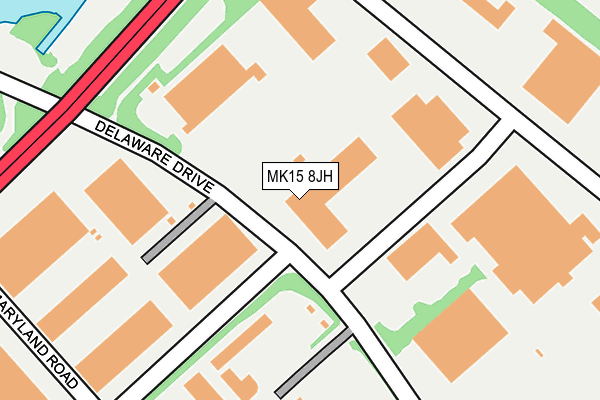
MK15 8JH is located in the Newport Pagnell South electoral ward, within the unitary authority of Milton Keynes and the English Parliamentary constituency of Milton Keynes North. The Sub Integrated Care Board (ICB) Location is NHS Bedfordshire, Luton and Milton Keynes ICB - M1J4Y and the police force is Thames Valley. This postcode has been in use since January 1991.


GetTheData
Source: OS OpenMap – Local (Ordnance Survey)
Source: OS VectorMap District (Ordnance Survey)
Licence: Open Government Licence (requires attribution)
| Easting | 487145 |
| Northing | 241912 |
| Latitude | 52.068733 |
| Longitude | -0.730077 |
GetTheData
Source: Open Postcode Geo
Licence: Open Government Licence
| Country | England |
| Postcode District | MK15 |
➜ See where MK15 is on a map ➜ Where is Milton Keynes? | |
GetTheData
Source: Land Registry Price Paid Data
Licence: Open Government Licence
Elevation or altitude of MK15 8JH as distance above sea level:
| Metres | Feet | |
|---|---|---|
| Elevation | 60m | 197ft |
Elevation is measured from the approximate centre of the postcode, to the nearest point on an OS contour line from OS Terrain 50, which has contour spacing of ten vertical metres.
➜ How high above sea level am I? Find the elevation of your current position using your device's GPS.
GetTheData
Source: Open Postcode Elevation
Licence: Open Government Licence
| Ward | Newport Pagnell South |
| Constituency | Milton Keynes North |
GetTheData
Source: ONS Postcode Database
Licence: Open Government Licence
| Delaware Drive | Tongwell | 69m |
| Delaware Drive | Tongwell | 79m |
| Maryland Road (Delaware Drive) | Tongwell | 353m |
| Tongwell Industrial Estate (Delaware Drive) | Tongwell | 364m |
| Maryland Road (Delaware Drive) | Tongwell | 383m |
| Milton Keynes Central Station | 4.9km |
GetTheData
Source: NaPTAN
Licence: Open Government Licence
GetTheData
Source: ONS Postcode Database
Licence: Open Government Licence


➜ Get more ratings from the Food Standards Agency
GetTheData
Source: Food Standards Agency
Licence: FSA terms & conditions
| Last Collection | |||
|---|---|---|---|
| Location | Mon-Fri | Sat | Distance |
| Michigan Drive | 18:30 | 79m | |
| Delaware Drive | 17:30 | 12:00 | 201m |
| Granville Square | 18:30 | 12:00 | 709m |
GetTheData
Source: Dracos
Licence: Creative Commons Attribution-ShareAlike
The below table lists the International Territorial Level (ITL) codes (formerly Nomenclature of Territorial Units for Statistics (NUTS) codes) and Local Administrative Units (LAU) codes for MK15 8JH:
| ITL 1 Code | Name |
|---|---|
| TLJ | South East (England) |
| ITL 2 Code | Name |
| TLJ1 | Berkshire, Buckinghamshire and Oxfordshire |
| ITL 3 Code | Name |
| TLJ12 | Milton Keynes |
| LAU 1 Code | Name |
| E06000042 | Milton Keynes |
GetTheData
Source: ONS Postcode Directory
Licence: Open Government Licence
The below table lists the Census Output Area (OA), Lower Layer Super Output Area (LSOA), and Middle Layer Super Output Area (MSOA) for MK15 8JH:
| Code | Name | |
|---|---|---|
| OA | E00084586 | |
| LSOA | E01016763 | Milton Keynes 007A |
| MSOA | E02003465 | Milton Keynes 007 |
GetTheData
Source: ONS Postcode Directory
Licence: Open Government Licence
| MK15 8JA | Vermont Place | 306m |
| MK15 8HR | Monks Way | 442m |
| MK15 9JR | Hooper Gate | 527m |
| MK15 9HA | Grimbald Court | 537m |
| MK15 9HB | Bentall Close | 539m |
| MK15 9HD | Portland Drive | 565m |
| MK15 9HX | Christian Court | 568m |
| MK14 5BT | Yeomans Drive | 579m |
| MK15 9LP | Portland Drive | 614m |
| MK15 9JU | Portland Drive | 622m |
GetTheData
Source: Open Postcode Geo; Land Registry Price Paid Data
Licence: Open Government Licence