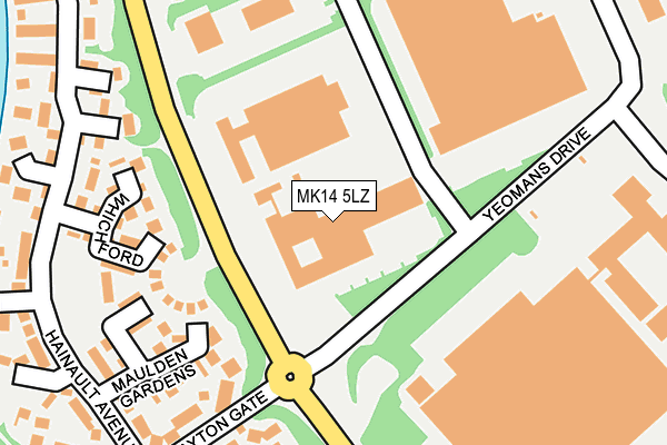
MK14 5LZ is located in the Newport Pagnell South electoral ward, within the unitary authority of Milton Keynes and the English Parliamentary constituency of Milton Keynes North. The Sub Integrated Care Board (ICB) Location is NHS Bedfordshire, Luton and Milton Keynes ICB - M1J4Y and the police force is Thames Valley. This postcode has been in use since June 2002.


GetTheData
Source: OS OpenMap – Local (Ordnance Survey)
Source: OS VectorMap District (Ordnance Survey)
Licence: Open Government Licence (requires attribution)
| Easting | 486418 |
| Northing | 242060 |
| Latitude | 52.070187 |
| Longitude | -0.740622 |
GetTheData
Source: Open Postcode Geo
Licence: Open Government Licence
| Country | England |
| Postcode District | MK14 |
➜ See where MK14 is on a map ➜ Where is Milton Keynes? | |
GetTheData
Source: Land Registry Price Paid Data
Licence: Open Government Licence
Elevation or altitude of MK14 5LZ as distance above sea level:
| Metres | Feet | |
|---|---|---|
| Elevation | 70m | 230ft |
Elevation is measured from the approximate centre of the postcode, to the nearest point on an OS contour line from OS Terrain 50, which has contour spacing of ten vertical metres.
➜ How high above sea level am I? Find the elevation of your current position using your device's GPS.
GetTheData
Source: Open Postcode Elevation
Licence: Open Government Licence
| Ward | Newport Pagnell South |
| Constituency | Milton Keynes North |
GetTheData
Source: ONS Postcode Database
Licence: Open Government Licence
| Yeomans Drive | Blakelands | 89m |
| Yeomans Drive | Blakelands | 114m |
| Yeomans Roundabout North (Brickhill Street V10) | Giffard Park | 145m |
| Yeomans Roundabout North (Brickhill Street V10) | Giffard Park | 162m |
| Hainault Avenue | Giffard Park | 305m |
| Wolverton Station | 4.4km |
| Milton Keynes Central Station | 4.6km |
GetTheData
Source: NaPTAN
Licence: Open Government Licence
GetTheData
Source: ONS Postcode Database
Licence: Open Government Licence


➜ Get more ratings from the Food Standards Agency
GetTheData
Source: Food Standards Agency
Licence: FSA terms & conditions
| Last Collection | |||
|---|---|---|---|
| Location | Mon-Fri | Sat | Distance |
| Hainault Avenue | 16:45 | 12:00 | 398m |
| Wedgewood Drive | 17:00 | 11:30 | 434m |
| Post Office Knebworth Gate | 18:00 | 12:00 | 512m |
GetTheData
Source: Dracos
Licence: Creative Commons Attribution-ShareAlike
The below table lists the International Territorial Level (ITL) codes (formerly Nomenclature of Territorial Units for Statistics (NUTS) codes) and Local Administrative Units (LAU) codes for MK14 5LZ:
| ITL 1 Code | Name |
|---|---|
| TLJ | South East (England) |
| ITL 2 Code | Name |
| TLJ1 | Berkshire, Buckinghamshire and Oxfordshire |
| ITL 3 Code | Name |
| TLJ12 | Milton Keynes |
| LAU 1 Code | Name |
| E06000042 | Milton Keynes |
GetTheData
Source: ONS Postcode Directory
Licence: Open Government Licence
The below table lists the Census Output Area (OA), Lower Layer Super Output Area (LSOA), and Middle Layer Super Output Area (MSOA) for MK14 5LZ:
| Code | Name | |
|---|---|---|
| OA | E00084586 | |
| LSOA | E01016763 | Milton Keynes 007A |
| MSOA | E02003465 | Milton Keynes 007 |
GetTheData
Source: ONS Postcode Directory
Licence: Open Government Licence
| MK14 5JJ | Maulden Gardens | 220m |
| MK14 5JH | Whichford | 227m |
| MK14 5BT | Yeomans Drive | 229m |
| MK14 5HN | Clayton Gate | 246m |
| MK14 5JW | Bessemer Court | 260m |
| MK14 5HW | Clayton Gate | 262m |
| MK14 5PL | Rainsborough | 266m |
| MK14 5JE | Hainault Avenue | 267m |
| MK14 5PQ | Hainault Avenue | 286m |
| MK14 5JF | Hainault Avenue | 289m |
GetTheData
Source: Open Postcode Geo; Land Registry Price Paid Data
Licence: Open Government Licence