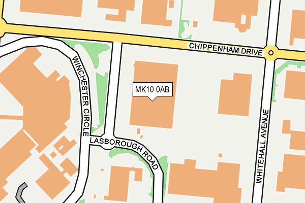
MK10 0AB is located in the Monkston electoral ward, within the unitary authority of Milton Keynes and the English Parliamentary constituency of Milton Keynes North. The Sub Integrated Care Board (ICB) Location is NHS Bedfordshire, Luton and Milton Keynes ICB - M1J4Y and the police force is Thames Valley. This postcode has been in use since January 1995.


GetTheData
Source: OS OpenMap – Local (Ordnance Survey)
Source: OS VectorMap District (Ordnance Survey)
Licence: Open Government Licence (requires attribution)
| Easting | 490321 |
| Northing | 238124 |
| Latitude | 52.034188 |
| Longitude | -0.684735 |
GetTheData
Source: Open Postcode Geo
Licence: Open Government Licence
| Country | England |
| Postcode District | MK10 |
➜ See where MK10 is on a map ➜ Where is Milton Keynes? | |
GetTheData
Source: Land Registry Price Paid Data
Licence: Open Government Licence
Elevation or altitude of MK10 0AB as distance above sea level:
| Metres | Feet | |
|---|---|---|
| Elevation | 60m | 197ft |
Elevation is measured from the approximate centre of the postcode, to the nearest point on an OS contour line from OS Terrain 50, which has contour spacing of ten vertical metres.
➜ How high above sea level am I? Find the elevation of your current position using your device's GPS.
GetTheData
Source: Open Postcode Elevation
Licence: Open Government Licence
| Ward | Monkston |
| Constituency | Milton Keynes North |
GetTheData
Source: ONS Postcode Database
Licence: Open Government Licence
| Lasborough Road (Standing Way H8) | Kingston | 102m |
| Lasborough Road (Standing Way H8) | Kingston | 134m |
| Kingston Roundabout West (Standing Way H8) | Kingston | 346m |
| Kingston Roundabout West (Standing Way H8) | Kingston | 354m |
| Brinklow Roundabout East (Standing Way H8) | Brinklow | 368m |
| Woburn Sands Station | 2.8km |
| Bow Brickhill Station | 3.4km |
| Aspley Guise Station | 3.9km |
GetTheData
Source: NaPTAN
Licence: Open Government Licence
GetTheData
Source: ONS Postcode Database
Licence: Open Government Licence


➜ Get more ratings from the Food Standards Agency
GetTheData
Source: Food Standards Agency
Licence: FSA terms & conditions
| Last Collection | |||
|---|---|---|---|
| Location | Mon-Fri | Sat | Distance |
| Tesco Stores | 18:30 | 12:00 | 286m |
| Chippenham Drive | 18:30 | 350m | |
| Brinklow Delivery Office | 19:15 | 12:30 | 568m |
GetTheData
Source: Dracos
Licence: Creative Commons Attribution-ShareAlike
The below table lists the International Territorial Level (ITL) codes (formerly Nomenclature of Territorial Units for Statistics (NUTS) codes) and Local Administrative Units (LAU) codes for MK10 0AB:
| ITL 1 Code | Name |
|---|---|
| TLJ | South East (England) |
| ITL 2 Code | Name |
| TLJ1 | Berkshire, Buckinghamshire and Oxfordshire |
| ITL 3 Code | Name |
| TLJ12 | Milton Keynes |
| LAU 1 Code | Name |
| E06000042 | Milton Keynes |
GetTheData
Source: ONS Postcode Directory
Licence: Open Government Licence
The below table lists the Census Output Area (OA), Lower Layer Super Output Area (LSOA), and Middle Layer Super Output Area (MSOA) for MK10 0AB:
| Code | Name | |
|---|---|---|
| OA | E00084688 | |
| LSOA | E01016783 | Milton Keynes 017A |
| MSOA | E02003475 | Milton Keynes 017 |
GetTheData
Source: ONS Postcode Directory
Licence: Open Government Licence
| MK10 0BA | Winchester Circle | 270m |
| MK10 9ER | Lindores Croft | 564m |
| MK7 6AU | 566m | |
| MK7 6DU | Millbank Place | 586m |
| MK10 9LU | Worth Court | 612m |
| MK10 9EP | Hurley Croft | 630m |
| MK7 6DZ | Shirley Moor | 636m |
| MK10 9EA | Lanercost Crescent | 653m |
| MK7 6DT | Wilsley Pound | 660m |
| MK7 6DW | Tudeley Hale | 668m |
GetTheData
Source: Open Postcode Geo; Land Registry Price Paid Data
Licence: Open Government Licence