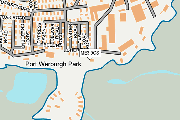
ME3 9GS is located in the Hoo St Werburgh & High Halstow electoral ward, within the unitary authority of Medway and the English Parliamentary constituency of Rochester and Strood. The Sub Integrated Care Board (ICB) Location is NHS Kent and Medway ICB - 91Q and the police force is Kent. This postcode has been in use since February 2017.


GetTheData
Source: OS OpenMap – Local (Ordnance Survey)
Source: OS VectorMap District (Ordnance Survey)
Licence: Open Government Licence (requires attribution)
| Easting | 578421 |
| Northing | 171169 |
| Latitude | 51.411469 |
| Longitude | 0.564223 |
GetTheData
Source: Open Postcode Geo
Licence: Open Government Licence
| Country | England |
| Postcode District | ME3 |
➜ See where ME3 is on a map | |
GetTheData
Source: Land Registry Price Paid Data
Licence: Open Government Licence
| Ward | Hoo St Werburgh & High Halstow |
| Constituency | Rochester And Strood |
GetTheData
Source: ONS Postcode Database
Licence: Open Government Licence
| Hoo Marina (Vicarage Lane) | Hoo St Werburgh | 270m |
| Church Farm Close (Vicarage Lane) | Hoo St Werburgh | 624m |
| Church Farm Close (Vicarage Lane) | Hoo St Werburgh | 625m |
| Five Bells (Main Road) | Hoo St Werburgh | 953m |
| Five Bells (Main Road) | Hoo St Werburgh | 968m |
| Gillingham (Kent) Station | 2.9km |
| Chatham Station | 4.6km |
| Rochester Station | 4.7km |
GetTheData
Source: NaPTAN
Licence: Open Government Licence
GetTheData
Source: ONS Postcode Database
Licence: Open Government Licence


➜ Get more ratings from the Food Standards Agency
GetTheData
Source: Food Standards Agency
Licence: FSA terms & conditions
| Last Collection | |||
|---|---|---|---|
| Location | Mon-Fri | Sat | Distance |
| Hoo Post Office | 17:15 | 11:15 | 947m |
| Moremont Road | 16:45 | 10:30 | 1,568m |
| Hoo Schools | 17:00 | 10:00 | 1,684m |
GetTheData
Source: Dracos
Licence: Creative Commons Attribution-ShareAlike
| Risk of ME3 9GS flooding from rivers and sea | Medium |
| ➜ ME3 9GS flood map | |
GetTheData
Source: Open Flood Risk by Postcode
Licence: Open Government Licence
The below table lists the International Territorial Level (ITL) codes (formerly Nomenclature of Territorial Units for Statistics (NUTS) codes) and Local Administrative Units (LAU) codes for ME3 9GS:
| ITL 1 Code | Name |
|---|---|
| TLJ | South East (England) |
| ITL 2 Code | Name |
| TLJ4 | Kent |
| ITL 3 Code | Name |
| TLJ41 | Medway |
| LAU 1 Code | Name |
| E06000035 | Medway |
GetTheData
Source: ONS Postcode Directory
Licence: Open Government Licence
The below table lists the Census Output Area (OA), Lower Layer Super Output Area (LSOA), and Middle Layer Super Output Area (MSOA) for ME3 9GS:
| Code | Name | |
|---|---|---|
| OA | E00167418 | |
| LSOA | E01016074 | Medway 001D |
| MSOA | E02003314 | Medway 001 |
GetTheData
Source: ONS Postcode Directory
Licence: Open Government Licence
| ME3 9AY | Church Farm Close | 627m |
| ME3 9BF | Branta Fields | 714m |
| ME3 9AN | Everest Drive | 760m |
| ME3 9AZ | Vicarage Lane | 790m |
| ME3 9AT | Everest Mews | 796m |
| ME3 9AL | Church Street | 796m |
| ME3 9AP | Armytage Close | 818m |
| ME3 9AS | Whitehouse Close | 820m |
| ME3 9LJ | Abbotts Court Road | 831m |
| ME3 9AW | Everest Drive | 837m |
GetTheData
Source: Open Postcode Geo; Land Registry Price Paid Data
Licence: Open Government Licence