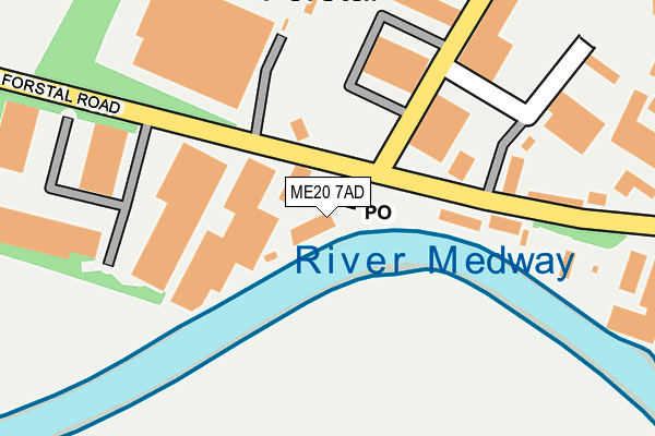
ME20 7AD is located in the Aylesford North & North Downs electoral ward, within the local authority district of Tonbridge and Malling and the English Parliamentary constituency of Chatham and Aylesford. The Sub Integrated Care Board (ICB) Location is NHS Kent and Medway ICB - 91Q and the police force is Kent. This postcode has been in use since January 1980.


GetTheData
Source: OS OpenMap – Local (Ordnance Survey)
Source: OS VectorMap District (Ordnance Survey)
Licence: Open Government Licence (requires attribution)
| Easting | 573764 |
| Northing | 158745 |
| Latitude | 51.301307 |
| Longitude | 0.491234 |
GetTheData
Source: Open Postcode Geo
Licence: Open Government Licence
| Country | England |
| Postcode District | ME20 |
➜ See where ME20 is on a map ➜ Where is Forstal? | |
GetTheData
Source: Land Registry Price Paid Data
Licence: Open Government Licence
Elevation or altitude of ME20 7AD as distance above sea level:
| Metres | Feet | |
|---|---|---|
| Elevation | 10m | 33ft |
Elevation is measured from the approximate centre of the postcode, to the nearest point on an OS contour line from OS Terrain 50, which has contour spacing of ten vertical metres.
➜ How high above sea level am I? Find the elevation of your current position using your device's GPS.
GetTheData
Source: Open Postcode Elevation
Licence: Open Government Licence
| Ward | Aylesford North & North Downs |
| Constituency | Chatham And Aylesford |
GetTheData
Source: ONS Postcode Database
Licence: Open Government Licence
| The Forstal (Forstal Road) | Aylesford | 106m |
| The Forstal (Forstal Road) | Aylesford | 155m |
| Deacon Trading Estate (Forstal Road) | Aylesford | 212m |
| Deacon Trading Estate (Forstal Road) | Aylesford | 277m |
| Cobtree Country Park (Forstal Road) | Aylesford | 510m |
| Aylesford Station | 1.7km |
| Barming Station | 2km |
| New Hythe Station | 2.8km |
GetTheData
Source: NaPTAN
Licence: Open Government Licence
Estimated total energy consumption in ME20 7AD by fuel type, 2015.
| Consumption (kWh) | 182,841 |
|---|---|
| Meter count | 10 |
| Mean (kWh/meter) | 18,284 |
| Median (kWh/meter) | 20,316 |
GetTheData
Source: Postcode level gas estimates: 2015 (experimental)
Source: Postcode level electricity estimates: 2015 (experimental)
Licence: Open Government Licence
GetTheData
Source: ONS Postcode Database
Licence: Open Government Licence


➜ Get more ratings from the Food Standards Agency
GetTheData
Source: Food Standards Agency
Licence: FSA terms & conditions
| Last Collection | |||
|---|---|---|---|
| Location | Mon-Fri | Sat | Distance |
| Forstall Road | 17:30 | 09:00 | 141m |
| Pratling Street | 16:45 | 09:00 | 644m |
| Aylesford Post Office | 17:15 | 11:15 | 809m |
GetTheData
Source: Dracos
Licence: Creative Commons Attribution-ShareAlike
| Risk of ME20 7AD flooding from rivers and sea | High |
| ➜ ME20 7AD flood map | |
GetTheData
Source: Open Flood Risk by Postcode
Licence: Open Government Licence
The below table lists the International Territorial Level (ITL) codes (formerly Nomenclature of Territorial Units for Statistics (NUTS) codes) and Local Administrative Units (LAU) codes for ME20 7AD:
| ITL 1 Code | Name |
|---|---|
| TLJ | South East (England) |
| ITL 2 Code | Name |
| TLJ4 | Kent |
| ITL 3 Code | Name |
| TLJ46 | West Kent |
| LAU 1 Code | Name |
| E07000115 | Tonbridge and Malling |
GetTheData
Source: ONS Postcode Directory
Licence: Open Government Licence
The below table lists the Census Output Area (OA), Lower Layer Super Output Area (LSOA), and Middle Layer Super Output Area (MSOA) for ME20 7AD:
| Code | Name | |
|---|---|---|
| OA | E00125473 | |
| LSOA | E01024717 | Tonbridge and Malling 005A |
| MSOA | E02005153 | Tonbridge and Malling 005 |
GetTheData
Source: ONS Postcode Directory
Licence: Open Government Licence
| ME20 7AJ | Waterside Quay | 118m |
| ME20 7AH | Forstal Road | 193m |
| ME20 7BT | Beddow Way | 215m |
| ME20 7AF | Motorway Industrial Estate | 320m |
| ME20 7AE | Forstal Road | 385m |
| ME20 7NS | Coldharbour Lane | 521m |
| ME20 7BW | Powell Close | 581m |
| ME20 7BN | Rochester Road | 594m |
| ME20 7BD | Unwin Close | 599m |
| ME20 7AU | Forstal Road | 609m |
GetTheData
Source: Open Postcode Geo; Land Registry Price Paid Data
Licence: Open Government Licence