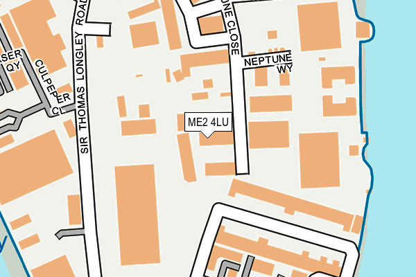
ME2 4LU is located in the Strood Rural electoral ward, within the unitary authority of Medway and the English Parliamentary constituency of Rochester and Strood. The Sub Integrated Care Board (ICB) Location is NHS Kent and Medway ICB - 91Q and the police force is Kent. This postcode has been in use since January 1995.


GetTheData
Source: OS OpenMap – Local (Ordnance Survey)
Source: OS VectorMap District (Ordnance Survey)
Licence: Open Government Licence (requires attribution)
| Easting | 575268 |
| Northing | 168879 |
| Latitude | 51.391880 |
| Longitude | 0.517773 |
GetTheData
Source: Open Postcode Geo
Licence: Open Government Licence
| Country | England |
| Postcode District | ME2 |
➜ See where ME2 is on a map ➜ Where is Rochester? | |
GetTheData
Source: Land Registry Price Paid Data
Licence: Open Government Licence
Elevation or altitude of ME2 4LU as distance above sea level:
| Metres | Feet | |
|---|---|---|
| Elevation | 10m | 33ft |
Elevation is measured from the approximate centre of the postcode, to the nearest point on an OS contour line from OS Terrain 50, which has contour spacing of ten vertical metres.
➜ How high above sea level am I? Find the elevation of your current position using your device's GPS.
GetTheData
Source: Open Postcode Elevation
Licence: Open Government Licence
| Ward | Strood Rural |
| Constituency | Rochester And Strood |
GetTheData
Source: ONS Postcode Database
Licence: Open Government Licence
| Sir Thomas Longley Road | Medway City Estate | 103m |
| Culpepper Close (Sir Thomas Longley Road) | Medway City Estate | 191m |
| Riverside Estate Scotline (Sir Thomas Longley Road) | Medway City Estate | 295m |
| Trident Close (Sir Thomas Longley Road) | Medway City Estate | 326m |
| Whitewall Way (Whitewall Road) | Medway City Estate | 429m |
| Rochester Station | 0.9km |
| Chatham Station | 1.3km |
| Strood Station | 1.3km |
GetTheData
Source: NaPTAN
Licence: Open Government Licence
| Median download speed | 7.5Mbps |
| Average download speed | 7.4Mbps |
| Maximum download speed | 9.53Mbps |
| Median upload speed | 0.9Mbps |
| Average upload speed | 0.9Mbps |
| Maximum upload speed | 1.13Mbps |
GetTheData
Source: Ofcom
Licence: Ofcom Terms of Use (requires attribution)
GetTheData
Source: ONS Postcode Database
Licence: Open Government Licence


➜ Get more ratings from the Food Standards Agency
GetTheData
Source: Food Standards Agency
Licence: FSA terms & conditions
| Last Collection | |||
|---|---|---|---|
| Location | Mon-Fri | Sat | Distance |
| Sir Thomas Longley Road | 18:30 | 11:00 | 173m |
| Centre Court | 18:30 | 11:00 | 317m |
| Centre Court Meter Box | 18:30 | 321m | |
GetTheData
Source: Dracos
Licence: Creative Commons Attribution-ShareAlike
The below table lists the International Territorial Level (ITL) codes (formerly Nomenclature of Territorial Units for Statistics (NUTS) codes) and Local Administrative Units (LAU) codes for ME2 4LU:
| ITL 1 Code | Name |
|---|---|
| TLJ | South East (England) |
| ITL 2 Code | Name |
| TLJ4 | Kent |
| ITL 3 Code | Name |
| TLJ41 | Medway |
| LAU 1 Code | Name |
| E06000035 | Medway |
GetTheData
Source: ONS Postcode Directory
Licence: Open Government Licence
The below table lists the Census Output Area (OA), Lower Layer Super Output Area (LSOA), and Middle Layer Super Output Area (MSOA) for ME2 4LU:
| Code | Name | |
|---|---|---|
| OA | E00081615 | |
| LSOA | E01016147 | Medway 004B |
| MSOA | E02003317 | Medway 004 |
GetTheData
Source: ONS Postcode Directory
Licence: Open Government Licence
| ME2 4NZ | Waterside Court | 201m |
| ME2 4FE | Beaufort Court | 208m |
| ME2 4BH | Riverside Estate | 213m |
| ME2 4LT | Neptune Close | 214m |
| ME2 4DU | Sir Thomas Longley Road | 219m |
| ME2 4DP | Riverside Estate | 238m |
| ME2 4QR | Clipper Court | 239m |
| ME2 4FX | Beaufort Court | 257m |
| ME2 4LW | Central Business Park | 303m |
| ME2 4FA | Beaufort Court | 303m |
GetTheData
Source: Open Postcode Geo; Land Registry Price Paid Data
Licence: Open Government Licence