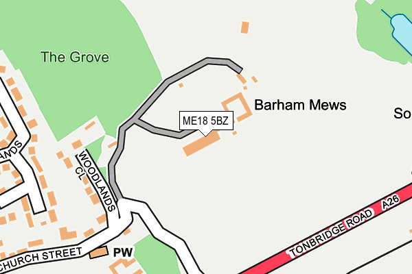
ME18 5BZ lies on Barham Court in Teston, Maidstone. ME18 5BZ is located in the Barming and Teston electoral ward, within the local authority district of Maidstone and the English Parliamentary constituency of Maidstone and The Weald. The Sub Integrated Care Board (ICB) Location is NHS Kent and Medway ICB - 91Q and the police force is Kent. This postcode has been in use since January 1980.


GetTheData
Source: OS OpenMap – Local (Ordnance Survey)
Source: OS VectorMap District (Ordnance Survey)
Licence: Open Government Licence (requires attribution)
| Easting | 570713 |
| Northing | 153686 |
| Latitude | 51.256780 |
| Longitude | 0.445125 |
GetTheData
Source: Open Postcode Geo
Licence: Open Government Licence
| Street | Barham Court |
| Locality | Teston |
| Town/City | Maidstone |
| Country | England |
| Postcode District | ME18 |
➜ See where ME18 is on a map | |
GetTheData
Source: Land Registry Price Paid Data
Licence: Open Government Licence
Elevation or altitude of ME18 5BZ as distance above sea level:
| Metres | Feet | |
|---|---|---|
| Elevation | 40m | 131ft |
Elevation is measured from the approximate centre of the postcode, to the nearest point on an OS contour line from OS Terrain 50, which has contour spacing of ten vertical metres.
➜ How high above sea level am I? Find the elevation of your current position using your device's GPS.
GetTheData
Source: Open Postcode Elevation
Licence: Open Government Licence
| Ward | Barming And Teston |
| Constituency | Maidstone And The Weald |
GetTheData
Source: ONS Postcode Database
Licence: Open Government Licence
| The Street (Tonbridge Road) | Teston | 433m |
| The Street (Tonbridge Road) | Teston | 436m |
| Livesey Street (Malling Road) | Teston | 505m |
| Livesey Street (Malling Road) | Teston | 524m |
| Valley Court (Tonbridge Road) | Teston | 915m |
| Wateringbury Station | 1.8km |
| East Farleigh Station | 2.8km |
| East Malling Station | 3.3km |
GetTheData
Source: NaPTAN
Licence: Open Government Licence
| Percentage of properties with Next Generation Access | 100.0% |
| Percentage of properties with Superfast Broadband | 100.0% |
| Percentage of properties with Ultrafast Broadband | 0.0% |
| Percentage of properties with Full Fibre Broadband | 0.0% |
Superfast Broadband is between 30Mbps and 300Mbps
Ultrafast Broadband is > 300Mbps
| Percentage of properties unable to receive 2Mbps | 0.0% |
| Percentage of properties unable to receive 5Mbps | 0.0% |
| Percentage of properties unable to receive 10Mbps | 0.0% |
| Percentage of properties unable to receive 30Mbps | 0.0% |
GetTheData
Source: Ofcom
Licence: Ofcom Terms of Use (requires attribution)
GetTheData
Source: ONS Postcode Database
Licence: Open Government Licence


➜ Get more ratings from the Food Standards Agency
GetTheData
Source: Food Standards Agency
Licence: FSA terms & conditions
| Last Collection | |||
|---|---|---|---|
| Location | Mon-Fri | Sat | Distance |
| Teston Post Office | 17:15 | 11:30 | 377m |
| West Farleigh Green | 16:15 | 09:00 | 1,230m |
| North Pole | 17:15 | 09:00 | 1,542m |
GetTheData
Source: Dracos
Licence: Creative Commons Attribution-ShareAlike
The below table lists the International Territorial Level (ITL) codes (formerly Nomenclature of Territorial Units for Statistics (NUTS) codes) and Local Administrative Units (LAU) codes for ME18 5BZ:
| ITL 1 Code | Name |
|---|---|
| TLJ | South East (England) |
| ITL 2 Code | Name |
| TLJ4 | Kent |
| ITL 3 Code | Name |
| TLJ45 | Mid Kent |
| LAU 1 Code | Name |
| E07000110 | Maidstone |
GetTheData
Source: ONS Postcode Directory
Licence: Open Government Licence
The below table lists the Census Output Area (OA), Lower Layer Super Output Area (LSOA), and Middle Layer Super Output Area (MSOA) for ME18 5BZ:
| Code | Name | |
|---|---|---|
| OA | E00123489 | |
| LSOA | E01024325 | Maidstone 014A |
| MSOA | E02005081 | Maidstone 014 |
GetTheData
Source: ONS Postcode Directory
Licence: Open Government Licence
| ME18 5BL | Barham Mews | 60m |
| ME18 5AL | Woodlands Close | 199m |
| ME18 5RB | Court Lodge Farm | 276m |
| ME18 5AS | Courtlands | 304m |
| ME18 5AJ | Church Street | 307m |
| ME18 5AT | Courtlands Close | 348m |
| ME18 5AH | The Bungalows | 372m |
| ME18 5AQ | The Street | 377m |
| ME18 5AR | Malling Road | 384m |
| ME18 5AN | Malling Road | 419m |
GetTheData
Source: Open Postcode Geo; Land Registry Price Paid Data
Licence: Open Government Licence