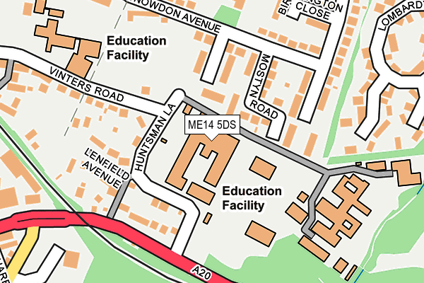
ME14 5DS is located in the High Street electoral ward, within the local authority district of Maidstone and the English Parliamentary constituency of Maidstone and The Weald. The Sub Integrated Care Board (ICB) Location is NHS Kent and Medway ICB - 91Q and the police force is Kent. This postcode has been in use since January 1980.


GetTheData
Source: OS OpenMap – Local (Ordnance Survey)
Source: OS VectorMap District (Ordnance Survey)
Licence: Open Government Licence (requires attribution)
| Easting | 577049 |
| Northing | 155884 |
| Latitude | 51.274595 |
| Longitude | 0.536890 |
GetTheData
Source: Open Postcode Geo
Licence: Open Government Licence
| Country | England |
| Postcode District | ME14 |
➜ See where ME14 is on a map ➜ Where is Maidstone? | |
GetTheData
Source: Land Registry Price Paid Data
Licence: Open Government Licence
Elevation or altitude of ME14 5DS as distance above sea level:
| Metres | Feet | |
|---|---|---|
| Elevation | 30m | 98ft |
Elevation is measured from the approximate centre of the postcode, to the nearest point on an OS contour line from OS Terrain 50, which has contour spacing of ten vertical metres.
➜ How high above sea level am I? Find the elevation of your current position using your device's GPS.
GetTheData
Source: Open Postcode Elevation
Licence: Open Government Licence
| Ward | High Street |
| Constituency | Maidstone And The Weald |
GetTheData
Source: ONS Postcode Database
Licence: Open Government Licence
| Invicta Girls Grammar School (Huntsman Lane) | Vinters Park | 83m |
| Mostyn Road (Snowdon Avenue) | Vinters Park | 144m |
| Mostyn Road (Snowdon Avenue) | Vinters Park | 157m |
| Turkey Mill (Ashford Road) | Maidstone | 306m |
| Turkey Mill (Ashford Road) | Maidstone | 314m |
| Maidstone East Station | 1.1km |
| Maidstone West Station | 1.5km |
| Maidstone Barracks Station | 1.6km |
GetTheData
Source: NaPTAN
Licence: Open Government Licence
GetTheData
Source: ONS Postcode Database
Licence: Open Government Licence


➜ Get more ratings from the Food Standards Agency
GetTheData
Source: Food Standards Agency
Licence: FSA terms & conditions
| Last Collection | |||
|---|---|---|---|
| Location | Mon-Fri | Sat | Distance |
| Vinters Park Estate | 17:30 | 12:30 | 168m |
| Claremont Road | 17:30 | 12:30 | 418m |
| Vinters | 18:30 | 12:30 | 450m |
GetTheData
Source: Dracos
Licence: Creative Commons Attribution-ShareAlike
The below table lists the International Territorial Level (ITL) codes (formerly Nomenclature of Territorial Units for Statistics (NUTS) codes) and Local Administrative Units (LAU) codes for ME14 5DS:
| ITL 1 Code | Name |
|---|---|
| TLJ | South East (England) |
| ITL 2 Code | Name |
| TLJ4 | Kent |
| ITL 3 Code | Name |
| TLJ45 | Mid Kent |
| LAU 1 Code | Name |
| E07000110 | Maidstone |
GetTheData
Source: ONS Postcode Directory
Licence: Open Government Licence
The below table lists the Census Output Area (OA), Lower Layer Super Output Area (LSOA), and Middle Layer Super Output Area (MSOA) for ME14 5DS:
| Code | Name | |
|---|---|---|
| OA | E00123723 | |
| LSOA | E01033092 | Maidstone 004G |
| MSOA | E02005071 | Maidstone 004 |
GetTheData
Source: ONS Postcode Directory
Licence: Open Government Licence
| ME14 5NX | Goldthorne Close | 90m |
| ME14 5NY | Mostyn Road | 97m |
| ME14 5PA | Alkham Road | 125m |
| ME14 5DR | Huntsman Lane | 131m |
| ME14 5NU | Snowdon Avenue | 144m |
| ME14 5DP | Ashford Road | 146m |
| ME14 5DU | Lenfield Avenue | 147m |
| ME14 5NT | Snowdon Avenue | 179m |
| ME14 5DL | Ashford Road | 192m |
| ME14 5DX | Vinters Road | 206m |
GetTheData
Source: Open Postcode Geo; Land Registry Price Paid Data
Licence: Open Government Licence