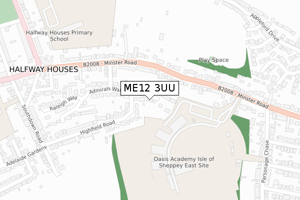
ME12 3UU is located in the Queenborough and Halfway electoral ward, within the local authority district of Swale and the English Parliamentary constituency of Sittingbourne and Sheppey. The Sub Integrated Care Board (ICB) Location is NHS Kent and Medway ICB - 91Q and the police force is Kent. This postcode has been in use since January 2020.


GetTheData
Source: OS Open Zoomstack (Ordnance Survey)
Licence: Open Government Licence (requires attribution)
Attribution: Contains OS data © Crown copyright and database right 2025
Source: Open Postcode Geo
Licence: Open Government Licence (requires attribution)
Attribution: Contains OS data © Crown copyright and database right 2025; Contains Royal Mail data © Royal Mail copyright and database right 2025; Source: Office for National Statistics licensed under the Open Government Licence v.3.0
| Easting | 593573 |
| Northing | 172770 |
| Latitude | 51.420885 |
| Longitude | 0.782708 |
GetTheData
Source: Open Postcode Geo
Licence: Open Government Licence
| Country | England |
| Postcode District | ME12 |
➜ See where ME12 is on a map ➜ Where is Halfway Houses? | |
GetTheData
Source: Land Registry Price Paid Data
Licence: Open Government Licence
| Ward | Queenborough And Halfway |
| Constituency | Sittingbourne And Sheppey |
GetTheData
Source: ONS Postcode Database
Licence: Open Government Licence
17, COMMODORES CLOSE, MINSTER ON SEA, SHEERNESS, ME12 3UU 2021 15 JAN £345,000 |
9, COMMODORES CLOSE, MINSTER ON SEA, SHEERNESS, ME12 3UU 2020 23 OCT £320,000 |
14, COMMODORES CLOSE, MINSTER ON SEA, SHEERNESS, ME12 3UU 2020 17 JUL £315,000 |
28, COMMODORES CLOSE, MINSTER ON SEA, SHEERNESS, ME12 3UU 2020 15 JUN £325,000 |
31, COMMODORES CLOSE, MINSTER ON SEA, SHEERNESS, ME12 3UU 2020 9 APR £315,000 |
2, COMMODORES CLOSE, MINSTER ON SEA, SHEERNESS, ME12 3UU 2020 28 FEB £315,000 |
5, COMMODORES CLOSE, MINSTER ON SEA, SHEERNESS, ME12 3UU 2020 28 FEB £335,000 |
1, COMMODORES CLOSE, MINSTER ON SEA, SHEERNESS, ME12 3UU 2020 7 FEB £315,000 |
GetTheData
Source: HM Land Registry Price Paid Data
Licence: Contains HM Land Registry data © Crown copyright and database right 2025. This data is licensed under the Open Government Licence v3.0.
| Banner Way (Minster Road) | Halfway | 148m |
| Isle Of Sheppey Academy East (Minster Road) | Minster | 154m |
| Banner Way (Minster Road) | Halfway | 156m |
| Isle Of Sheppey Academy East Grounds (Academy Grounds) | Minster | 206m |
| Isle Of Sheppey Academy East (Minster Road) | Minster | 244m |
| Queenborough Station | 2.4km |
| Sheerness-on-Sea Station | 2.8km |
| Swale Station | 4.3km |
GetTheData
Source: NaPTAN
Licence: Open Government Licence
GetTheData
Source: ONS Postcode Database
Licence: Open Government Licence


➜ Get more ratings from the Food Standards Agency
GetTheData
Source: Food Standards Agency
Licence: FSA terms & conditions
| Last Collection | |||
|---|---|---|---|
| Location | Mon-Fri | Sat | Distance |
| Parsonage Chase | 16:15 | 11:30 | 352m |
| Halfway Houses Post Office | 17:15 | 12:00 | 359m |
| Marina Estate | 16:00 | 09:00 | 735m |
GetTheData
Source: Dracos
Licence: Creative Commons Attribution-ShareAlike
The below table lists the International Territorial Level (ITL) codes (formerly Nomenclature of Territorial Units for Statistics (NUTS) codes) and Local Administrative Units (LAU) codes for ME12 3UU:
| ITL 1 Code | Name |
|---|---|
| TLJ | South East (England) |
| ITL 2 Code | Name |
| TLJ4 | Kent |
| ITL 3 Code | Name |
| TLJ43 | Kent Thames Gateway |
| LAU 1 Code | Name |
| E07000113 | Swale |
GetTheData
Source: ONS Postcode Directory
Licence: Open Government Licence
The below table lists the Census Output Area (OA), Lower Layer Super Output Area (LSOA), and Middle Layer Super Output Area (MSOA) for ME12 3UU:
| Code | Name | |
|---|---|---|
| OA | E00124825 | |
| LSOA | E01024598 | Swale 004B |
| MSOA | E02005118 | Swale 004 |
GetTheData
Source: ONS Postcode Directory
Licence: Open Government Licence
| ME12 3JJ | Minster Road | 122m |
| ME12 3AZ | Highfield Road | 128m |
| ME12 3AY | Admirals Walk | 156m |
| ME12 3AX | Banner Way | 193m |
| ME12 3JH | Minster Road | 195m |
| ME12 3JF | Minster Road | 263m |
| ME12 3BB | Admirals Walk | 276m |
| ME12 3JG | Pleasant Place | 293m |
| ME12 3BA | Highfield Road | 308m |
| ME12 3BH | Raleigh Way | 339m |
GetTheData
Source: Open Postcode Geo; Land Registry Price Paid Data
Licence: Open Government Licence