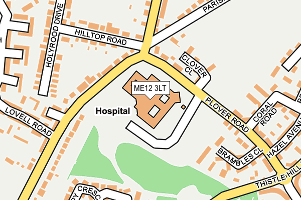
ME12 3LT is located in the Sheppey Central electoral ward, within the local authority district of Swale and the English Parliamentary constituency of Sittingbourne and Sheppey. The Sub Integrated Care Board (ICB) Location is NHS Kent and Medway ICB - 91Q and the police force is Kent. This postcode has been in use since November 2002.


GetTheData
Source: OS OpenMap – Local (Ordnance Survey)
Source: OS VectorMap District (Ordnance Survey)
Licence: Open Government Licence (requires attribution)
| Easting | 594318 |
| Northing | 172189 |
| Latitude | 51.415409 |
| Longitude | 0.793061 |
GetTheData
Source: Open Postcode Geo
Licence: Open Government Licence
| Country | England |
| Postcode District | ME12 |
➜ See where ME12 is on a map ➜ Where is Minster? | |
GetTheData
Source: Land Registry Price Paid Data
Licence: Open Government Licence
Elevation or altitude of ME12 3LT as distance above sea level:
| Metres | Feet | |
|---|---|---|
| Elevation | 20m | 66ft |
Elevation is measured from the approximate centre of the postcode, to the nearest point on an OS contour line from OS Terrain 50, which has contour spacing of ten vertical metres.
➜ How high above sea level am I? Find the elevation of your current position using your device's GPS.
GetTheData
Source: Open Postcode Elevation
Licence: Open Government Licence
| Ward | Sheppey Central |
| Constituency | Sittingbourne And Sheppey |
GetTheData
Source: ONS Postcode Database
Licence: Open Government Licence
| Sheppey Hospital (Plover Road) | Minster | 44m |
| Sheppey Hospital (Plover Road) | Minster | 77m |
| Barton Hill Top (Barton Hill Drive) | Minster | 82m |
| Sheppey Hospital (Plover Road) | Minster | 118m |
| Lovell Road (Barton Hill Drive) | Minster | 185m |
| Queenborough Station | 3km |
| Sheerness-on-Sea Station | 3.7km |
| Swale Station | 4.3km |
GetTheData
Source: NaPTAN
Licence: Open Government Licence
GetTheData
Source: ONS Postcode Database
Licence: Open Government Licence


➜ Get more ratings from the Food Standards Agency
GetTheData
Source: Food Standards Agency
Licence: FSA terms & conditions
| Last Collection | |||
|---|---|---|---|
| Location | Mon-Fri | Sat | Distance |
| Brambledown | 16:15 | 11:15 | 484m |
| East Minster Post Office | 16:30 | 11:30 | 597m |
| Parsonage Chase | 16:15 | 11:30 | 695m |
GetTheData
Source: Dracos
Licence: Creative Commons Attribution-ShareAlike
The below table lists the International Territorial Level (ITL) codes (formerly Nomenclature of Territorial Units for Statistics (NUTS) codes) and Local Administrative Units (LAU) codes for ME12 3LT:
| ITL 1 Code | Name |
|---|---|
| TLJ | South East (England) |
| ITL 2 Code | Name |
| TLJ4 | Kent |
| ITL 3 Code | Name |
| TLJ43 | Kent Thames Gateway |
| LAU 1 Code | Name |
| E07000113 | Swale |
GetTheData
Source: ONS Postcode Directory
Licence: Open Government Licence
The below table lists the Census Output Area (OA), Lower Layer Super Output Area (LSOA), and Middle Layer Super Output Area (MSOA) for ME12 3LT:
| Code | Name | |
|---|---|---|
| OA | E00166804 | |
| LSOA | E01032653 | Swale 004F |
| MSOA | E02005118 | Swale 004 |
GetTheData
Source: ONS Postcode Directory
Licence: Open Government Licence
| ME12 3BT | Yarrow Drive | 127m |
| ME12 3ND | Barton Hill Drive | 131m |
| ME12 3EQ | Plover Road | 168m |
| ME12 3NB | Hilltop Road | 183m |
| ME12 3GD | Brambles Close | 183m |
| ME12 3NN | Miller Court | 211m |
| ME12 3GA | Plover Road | 212m |
| ME12 3GL | Mimosa Avenue | 219m |
| ME12 3NF | Barton Hill Drive | 229m |
| ME12 3JZ | Summerville Avenue | 230m |
GetTheData
Source: Open Postcode Geo; Land Registry Price Paid Data
Licence: Open Government Licence