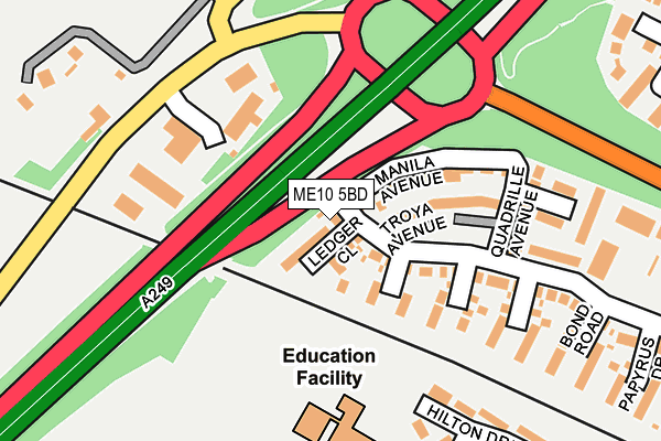
ME10 5BD is located in the The Meads electoral ward, within the local authority district of Swale and the English Parliamentary constituency of Sittingbourne and Sheppey. The Sub Integrated Care Board (ICB) Location is NHS Kent and Medway ICB - 91Q and the police force is Kent. This postcode has been in use since June 2017.


GetTheData
Source: OS OpenMap – Local (Ordnance Survey)
Source: OS VectorMap District (Ordnance Survey)
Licence: Open Government Licence (requires attribution)
| Easting | 588727 |
| Northing | 164762 |
| Latitude | 51.350591 |
| Longitude | 0.708843 |
GetTheData
Source: Open Postcode Geo
Licence: Open Government Licence
| Country | England |
| Postcode District | ME10 |
➜ See where ME10 is on a map ➜ Where is Sittingbourne? | |
GetTheData
Source: Land Registry Price Paid Data
Licence: Open Government Licence
| Ward | The Meads |
| Constituency | Sittingbourne And Sheppey |
GetTheData
Source: ONS Postcode Database
Licence: Open Government Licence
| Bobbing Apple (Sheppey Way) | Bobbing | 234m |
| Bobbing Apple (Sheppey Way) | Bobbing | 244m |
| Church (Sheppey Way) | Bobbing | 358m |
| Church (Sheppey Way) | Bobbing | 368m |
| The Meads (Sonora Way) | Sonora Fields | 429m |
| Sittingbourne Station | 2km |
| Kemsley Station | 2.3km |
| Newington Station | 2.8km |
GetTheData
Source: NaPTAN
Licence: Open Government Licence
| Percentage of properties with Next Generation Access | 100.0% |
| Percentage of properties with Superfast Broadband | 100.0% |
| Percentage of properties with Ultrafast Broadband | 0.0% |
| Percentage of properties with Full Fibre Broadband | 0.0% |
Superfast Broadband is between 30Mbps and 300Mbps
Ultrafast Broadband is > 300Mbps
| Percentage of properties unable to receive 2Mbps | 0.0% |
| Percentage of properties unable to receive 5Mbps | 0.0% |
| Percentage of properties unable to receive 10Mbps | 0.0% |
| Percentage of properties unable to receive 30Mbps | 0.0% |
GetTheData
Source: Ofcom
Licence: Ofcom Terms of Use (requires attribution)
GetTheData
Source: ONS Postcode Database
Licence: Open Government Licence


➜ Get more ratings from the Food Standards Agency
GetTheData
Source: Food Standards Agency
Licence: FSA terms & conditions
| Last Collection | |||
|---|---|---|---|
| Location | Mon-Fri | Sat | Distance |
| Bobbing Church | 16:30 | 09:00 | 365m |
| Gadby Road (Ex P O) | 17:30 | 11:30 | 444m |
| Sonora Way | 17:15 | 09:00 | 540m |
GetTheData
Source: Dracos
Licence: Creative Commons Attribution-ShareAlike
The below table lists the International Territorial Level (ITL) codes (formerly Nomenclature of Territorial Units for Statistics (NUTS) codes) and Local Administrative Units (LAU) codes for ME10 5BD:
| ITL 1 Code | Name |
|---|---|
| TLJ | South East (England) |
| ITL 2 Code | Name |
| TLJ4 | Kent |
| ITL 3 Code | Name |
| TLJ43 | Kent Thames Gateway |
| LAU 1 Code | Name |
| E07000113 | Swale |
GetTheData
Source: ONS Postcode Directory
Licence: Open Government Licence
The below table lists the Census Output Area (OA), Lower Layer Super Output Area (LSOA), and Middle Layer Super Output Area (MSOA) for ME10 5BD:
| Code | Name | |
|---|---|---|
| OA | E00124708 | |
| LSOA | E01024568 | Swale 009D |
| MSOA | E02005123 | Swale 009 |
GetTheData
Source: ONS Postcode Directory
Licence: Open Government Licence
| ME10 5BB | Vellum Drive | 155m |
| ME10 5BN | Parchment Drive | 179m |
| ME10 1PT | Hilton Drive | 188m |
| ME10 1LU | Wellington Road | 236m |
| ME10 5BL | Bond Road | 238m |
| ME10 1PU | Hilton Drive | 270m |
| ME10 1LY | Collingwood Walk | 298m |
| ME10 1LZ | Nelson Walk | 316m |
| ME9 8PL | Sheppey Way | 320m |
| ME10 5LB | Galena Close | 324m |
GetTheData
Source: Open Postcode Geo; Land Registry Price Paid Data
Licence: Open Government Licence