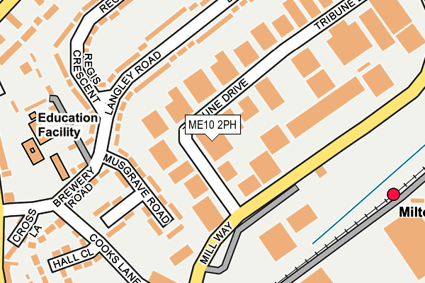
ME10 2PH is located in the Milton Regis electoral ward, within the local authority district of Swale and the English Parliamentary constituency of Sittingbourne and Sheppey. The Sub Integrated Care Board (ICB) Location is NHS Kent and Medway ICB - 91Q and the police force is Kent. This postcode has been in use since January 1980.


GetTheData
Source: OS OpenMap – Local (Ordnance Survey)
Source: OS VectorMap District (Ordnance Survey)
Licence: Open Government Licence (requires attribution)
| Easting | 590675 |
| Northing | 164869 |
| Latitude | 51.350903 |
| Longitude | 0.736840 |
GetTheData
Source: Open Postcode Geo
Licence: Open Government Licence
| Country | England |
| Postcode District | ME10 |
➜ See where ME10 is on a map ➜ Where is Sittingbourne? | |
GetTheData
Source: Land Registry Price Paid Data
Licence: Open Government Licence
Elevation or altitude of ME10 2PH as distance above sea level:
| Metres | Feet | |
|---|---|---|
| Elevation | 10m | 33ft |
Elevation is measured from the approximate centre of the postcode, to the nearest point on an OS contour line from OS Terrain 50, which has contour spacing of ten vertical metres.
➜ How high above sea level am I? Find the elevation of your current position using your device's GPS.
GetTheData
Source: Open Postcode Elevation
Licence: Open Government Licence
| Ward | Milton Regis |
| Constituency | Sittingbourne And Sheppey |
GetTheData
Source: ONS Postcode Database
Licence: Open Government Licence
| Asda (Mill Way) | Milton Regis | 250m |
| Asda (Mill Way) | Milton Regis | 282m |
| Court Road (North Street) | Milton Regis | 344m |
| Court Road (North Street) | Milton Regis | 357m |
| The Three Hats (High Street) | Milton Regis | 363m |
| Sittingbourne Station | 1km |
| Kemsley Station | 1.3km |
| Swale Station | 4.3km |
GetTheData
Source: NaPTAN
Licence: Open Government Licence
GetTheData
Source: ONS Postcode Database
Licence: Open Government Licence


➜ Get more ratings from the Food Standards Agency
GetTheData
Source: Food Standards Agency
Licence: FSA terms & conditions
| Last Collection | |||
|---|---|---|---|
| Location | Mon-Fri | Sat | Distance |
| Trinity Estate Meter Box | 18:30 | 265m | |
| Milton Regis Post Office | 17:15 | 12:00 | 323m |
| North Street Lower | 17:30 | 11:45 | 463m |
GetTheData
Source: Dracos
Licence: Creative Commons Attribution-ShareAlike
| Risk of ME10 2PH flooding from rivers and sea | Medium |
| ➜ ME10 2PH flood map | |
GetTheData
Source: Open Flood Risk by Postcode
Licence: Open Government Licence
The below table lists the International Territorial Level (ITL) codes (formerly Nomenclature of Territorial Units for Statistics (NUTS) codes) and Local Administrative Units (LAU) codes for ME10 2PH:
| ITL 1 Code | Name |
|---|---|
| TLJ | South East (England) |
| ITL 2 Code | Name |
| TLJ4 | Kent |
| ITL 3 Code | Name |
| TLJ43 | Kent Thames Gateway |
| LAU 1 Code | Name |
| E07000113 | Swale |
GetTheData
Source: ONS Postcode Directory
Licence: Open Government Licence
The below table lists the Census Output Area (OA), Lower Layer Super Output Area (LSOA), and Middle Layer Super Output Area (MSOA) for ME10 2PH:
| Code | Name | |
|---|---|---|
| OA | E00124779 | |
| LSOA | E01024584 | Swale 010B |
| MSOA | E02005124 | Swale 010 |
GetTheData
Source: ONS Postcode Directory
Licence: Open Government Licence
| ME10 2EH | Langley Road | 136m |
| ME10 2EJ | Musgrave Road | 136m |
| ME10 2EN | Langley Road | 139m |
| ME10 2PG | Trinity Trading Estate | 166m |
| ME10 2EQ | Albion Terrace | 204m |
| ME10 2EE | Brewery Road | 216m |
| ME10 2EP | Regis Crescent | 220m |
| ME10 2QG | Cooks Lane | 232m |
| ME10 2EG | Brewery Road | 243m |
| ME10 2ES | Regis Crescent | 260m |
GetTheData
Source: Open Postcode Geo; Land Registry Price Paid Data
Licence: Open Government Licence