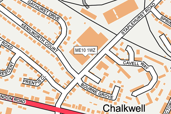
ME10 1WZ is located in the Borden and Grove Park electoral ward, within the local authority district of Swale and the English Parliamentary constituency of Sittingbourne and Sheppey. The Sub Integrated Care Board (ICB) Location is NHS Kent and Medway ICB - 91Q and the police force is Kent. This postcode has been in use since December 1999.


GetTheData
Source: OS OpenMap – Local (Ordnance Survey)
Source: OS VectorMap District (Ordnance Survey)
Licence: Open Government Licence (requires attribution)
| Easting | 589444 |
| Northing | 164145 |
| Latitude | 51.344810 |
| Longitude | 0.718769 |
GetTheData
Source: Open Postcode Geo
Licence: Open Government Licence
| Country | England |
| Postcode District | ME10 |
➜ See where ME10 is on a map ➜ Where is Sittingbourne? | |
GetTheData
Source: Land Registry Price Paid Data
Licence: Open Government Licence
Elevation or altitude of ME10 1WZ as distance above sea level:
| Metres | Feet | |
|---|---|---|
| Elevation | 20m | 66ft |
Elevation is measured from the approximate centre of the postcode, to the nearest point on an OS contour line from OS Terrain 50, which has contour spacing of ten vertical metres.
➜ How high above sea level am I? Find the elevation of your current position using your device's GPS.
GetTheData
Source: Open Postcode Elevation
Licence: Open Government Licence
| Ward | Borden And Grove Park |
| Constituency | Sittingbourne And Sheppey |
GetTheData
Source: ONS Postcode Database
Licence: Open Government Licence
| Kenilworth Court | Milton Regis | 113m |
| Bourne Grove (Staplehurst Road) | Milton Regis | 116m |
| Gadby Road | Milton Regis | 194m |
| Cryalls Lane (London Road) | Sittingbourne | 196m |
| Cryalls Lane (London Road) | Chalkwell | 209m |
| Sittingbourne Station | 1.2km |
| Kemsley Station | 2.3km |
| Newington Station | 3.6km |
GetTheData
Source: NaPTAN
Licence: Open Government Licence
GetTheData
Source: ONS Postcode Database
Licence: Open Government Licence


➜ Get more ratings from the Food Standards Agency
GetTheData
Source: Food Standards Agency
Licence: FSA terms & conditions
| Last Collection | |||
|---|---|---|---|
| Location | Mon-Fri | Sat | Distance |
| Wellwinch Road | 17:30 | 12:00 | 308m |
| Lower Borden Lane | 16:00 | 09:00 | 431m |
| Chalkwell Post Office | 17:15 | 11:30 | 508m |
GetTheData
Source: Dracos
Licence: Creative Commons Attribution-ShareAlike
The below table lists the International Territorial Level (ITL) codes (formerly Nomenclature of Territorial Units for Statistics (NUTS) codes) and Local Administrative Units (LAU) codes for ME10 1WZ:
| ITL 1 Code | Name |
|---|---|
| TLJ | South East (England) |
| ITL 2 Code | Name |
| TLJ4 | Kent |
| ITL 3 Code | Name |
| TLJ43 | Kent Thames Gateway |
| LAU 1 Code | Name |
| E07000113 | Swale |
GetTheData
Source: ONS Postcode Directory
Licence: Open Government Licence
The below table lists the Census Output Area (OA), Lower Layer Super Output Area (LSOA), and Middle Layer Super Output Area (MSOA) for ME10 1WZ:
| Code | Name | |
|---|---|---|
| OA | E00124699 | |
| LSOA | E01024567 | Swale 009C |
| MSOA | E02005123 | Swale 009 |
GetTheData
Source: ONS Postcode Directory
Licence: Open Government Licence
| ME10 1TY | Kenilworth Court | 93m |
| ME10 1EJ | Ashington Close | 98m |
| ME10 1UE | Gayhurst Drive | 124m |
| ME10 1SY | Staplehurst Road | 129m |
| ME10 1SZ | Bourne Grove | 134m |
| ME10 1TF | Gadby Road | 156m |
| ME10 1TD | Gadby Road | 185m |
| ME10 1NS | London Road | 194m |
| ME10 1TE | Prentis Close | 223m |
| ME10 1TZ | Kenilworth Court | 227m |
GetTheData
Source: Open Postcode Geo; Land Registry Price Paid Data
Licence: Open Government Licence