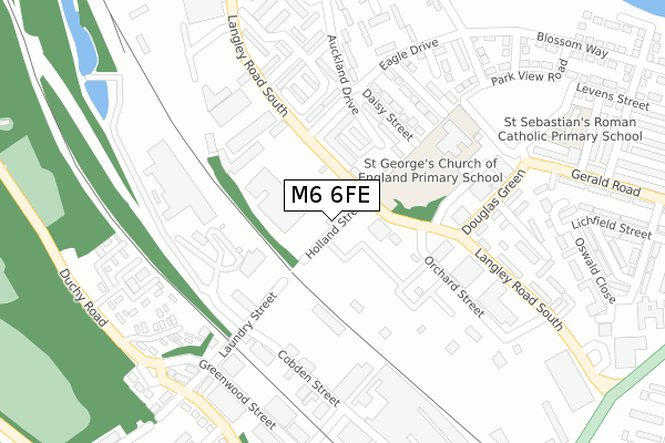
M6 6FE lies on Holland Street in Salford. M6 6FE is located in the Pendleton & Charlestown electoral ward, within the metropolitan district of Salford and the English Parliamentary constituency of Salford and Eccles. The Sub Integrated Care Board (ICB) Location is NHS Greater Manchester ICB - 01G and the police force is Greater Manchester. This postcode has been in use since May 1994.


GetTheData
Source: OS Open Zoomstack (Ordnance Survey)
Licence: Open Government Licence (requires attribution)
Attribution: Contains OS data © Crown copyright and database right 2025
Source: Open Postcode Geo
Licence: Open Government Licence (requires attribution)
Attribution: Contains OS data © Crown copyright and database right 2025; Contains Royal Mail data © Royal Mail copyright and database right 2025; Source: Office for National Statistics licensed under the Open Government Licence v.3.0
| Easting | 381039 |
| Northing | 400099 |
| Latitude | 53.497246 |
| Longitude | -2.287290 |
GetTheData
Source: Open Postcode Geo
Licence: Open Government Licence
| Street | Holland Street |
| Town/City | Salford |
| Country | England |
| Postcode District | M6 |
➜ See where M6 is on a map ➜ Where is Salford? | |
GetTheData
Source: Land Registry Price Paid Data
Licence: Open Government Licence
Elevation or altitude of M6 6FE as distance above sea level:
| Metres | Feet | |
|---|---|---|
| Elevation | 40m | 131ft |
Elevation is measured from the approximate centre of the postcode, to the nearest point on an OS contour line from OS Terrain 50, which has contour spacing of ten vertical metres.
➜ How high above sea level am I? Find the elevation of your current position using your device's GPS.
GetTheData
Source: Open Postcode Elevation
Licence: Open Government Licence
| Ward | Pendleton & Charlestown |
| Constituency | Salford And Eccles |
GetTheData
Source: ONS Postcode Database
Licence: Open Government Licence
| Langley Rd South/Holland St (Langley Rd Sth) | Brindle Heath | 57m |
| Langley Rd South/Holland Walk (Langley Rd Sth) | Brindle Heath | 67m |
| Owen St/Langley Rd South (Owen St) | Charlestown | 169m |
| Owen St/Langley Rd South (Owen St) | Charlestown | 171m |
| Langley Rd South/Douglas Green (Langley Rd Sth) | Charlestown | 247m |
| Salford Crescent Station | 1.4km |
| Salford Central Station | 2.7km |
| Manchester Victoria Station | 3.2km |
GetTheData
Source: NaPTAN
Licence: Open Government Licence
GetTheData
Source: ONS Postcode Database
Licence: Open Government Licence


➜ Get more ratings from the Food Standards Agency
GetTheData
Source: Food Standards Agency
Licence: FSA terms & conditions
| Last Collection | |||
|---|---|---|---|
| Location | Mon-Fri | Sat | Distance |
| 34 Cresent/Hulme Place | 17:30 | 12:00 | 626m |
| Cromwell Bridge P.o. | 17:30 | 12:00 | 647m |
| Strawberry Road / Broad Street | 17:30 | 11:45 | 905m |
GetTheData
Source: Dracos
Licence: Creative Commons Attribution-ShareAlike
The below table lists the International Territorial Level (ITL) codes (formerly Nomenclature of Territorial Units for Statistics (NUTS) codes) and Local Administrative Units (LAU) codes for M6 6FE:
| ITL 1 Code | Name |
|---|---|
| TLD | North West (England) |
| ITL 2 Code | Name |
| TLD3 | Greater Manchester |
| ITL 3 Code | Name |
| TLD34 | Greater Manchester South West |
| LAU 1 Code | Name |
| E08000006 | Salford |
GetTheData
Source: ONS Postcode Directory
Licence: Open Government Licence
The below table lists the Census Output Area (OA), Lower Layer Super Output Area (LSOA), and Middle Layer Super Output Area (MSOA) for M6 6FE:
| Code | Name | |
|---|---|---|
| OA | E00028773 | |
| LSOA | E01005683 | Salford 017C |
| MSOA | E02001173 | Salford 017 |
GetTheData
Source: ONS Postcode Directory
Licence: Open Government Licence
| M6 6RT | Owen Street | 179m |
| M6 6SE | Langley Road South | 235m |
| M6 6HP | Auckland Drive | 250m |
| M6 6WG | Cobden Street | 252m |
| M6 6WF | Cobden Street | 263m |
| M6 6SN | Withycombe Place | 287m |
| M6 6RJ | Greenstone Drive | 304m |
| M6 6EW | Ascot Walk | 313m |
| M6 6GE | Brindleheath Road | 357m |
| M6 6HS | Haymond Close | 360m |
GetTheData
Source: Open Postcode Geo; Land Registry Price Paid Data
Licence: Open Government Licence