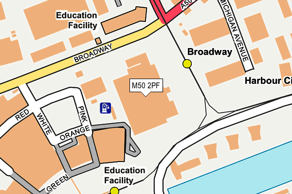
M50 2PF is located in the Quays electoral ward, within the metropolitan district of Salford and the English Parliamentary constituency of Salford and Eccles. The Sub Integrated Care Board (ICB) Location is NHS Greater Manchester ICB - 01G and the police force is Greater Manchester. This postcode has been in use since June 2010.


GetTheData
Source: OS OpenMap – Local (Ordnance Survey)
Source: OS VectorMap District (Ordnance Survey)
Licence: Open Government Licence (requires attribution)
| Easting | 380442 |
| Northing | 397529 |
| Latitude | 53.474141 |
| Longitude | -2.296128 |
GetTheData
Source: Open Postcode Geo
Licence: Open Government Licence
| Country | England |
| Postcode District | M50 |
➜ See where M50 is on a map ➜ Where is Salford? | |
GetTheData
Source: Land Registry Price Paid Data
Licence: Open Government Licence
Elevation or altitude of M50 2PF as distance above sea level:
| Metres | Feet | |
|---|---|---|
| Elevation | 30m | 98ft |
Elevation is measured from the approximate centre of the postcode, to the nearest point on an OS contour line from OS Terrain 50, which has contour spacing of ten vertical metres.
➜ How high above sea level am I? Find the elevation of your current position using your device's GPS.
GetTheData
Source: Open Postcode Elevation
Licence: Open Government Licence
| Ward | Quays |
| Constituency | Salford And Eccles |
GetTheData
Source: ONS Postcode Database
Licence: Open Government Licence
| Broadway/The Pie Factory (Broadway) | Broadway | 98m |
| Broadway/The Pie Factory (Broadway) | Broadway | 114m |
| Broadway/Paragon House (Broadway) | Broadway | 198m |
| Broadway/Paragon House (Broadway) | Broadway | 219m |
| The Quays/Mediacityuk (The Quays) | Mediacityuk | 249m |
| Broadway (Manchester Metrolink) (Off Broadway) | Broadway | 115m |
| Mediacityuk (Manchester Metrolink) | Mediacityuk | 237m |
| Harbour City (Manchester Metrolink) (The Quays) | The Lowry | 268m |
| Anchorage (Manchester Metrolink) (Anchorage Quay) | Salford Quays | 667m |
| Langworthy (Manchester Metrolink) (Eccles New Road) | Langworthy | 728m |
| Manchester United FC Station | 1.4km |
| Salford Crescent Station | 1.9km |
| Trafford Park Station | 2.4km |
GetTheData
Source: NaPTAN
Licence: Open Government Licence
GetTheData
Source: ONS Postcode Database
Licence: Open Government Licence


➜ Get more ratings from the Food Standards Agency
GetTheData
Source: Food Standards Agency
Licence: FSA terms & conditions
| Last Collection | |||
|---|---|---|---|
| Location | Mon-Fri | Sat | Distance |
| North Stage | 205m | ||
| Exchange Quay P.o. | 17:30 | 12:00 | 463m |
| Winnipeg Quay Salford Quays | 17:30 | 12:00 | 535m |
GetTheData
Source: Dracos
Licence: Creative Commons Attribution-ShareAlike
| Risk of M50 2PF flooding from rivers and sea | Low |
| ➜ M50 2PF flood map | |
GetTheData
Source: Open Flood Risk by Postcode
Licence: Open Government Licence
The below table lists the International Territorial Level (ITL) codes (formerly Nomenclature of Territorial Units for Statistics (NUTS) codes) and Local Administrative Units (LAU) codes for M50 2PF:
| ITL 1 Code | Name |
|---|---|
| TLD | North West (England) |
| ITL 2 Code | Name |
| TLD3 | Greater Manchester |
| ITL 3 Code | Name |
| TLD34 | Greater Manchester South West |
| LAU 1 Code | Name |
| E08000006 | Salford |
GetTheData
Source: ONS Postcode Directory
Licence: Open Government Licence
The below table lists the Census Output Area (OA), Lower Layer Super Output Area (LSOA), and Middle Layer Super Output Area (MSOA) for M50 2PF:
| Code | Name | |
|---|---|---|
| OA | E00172920 | |
| LSOA | E01032685 | Salford 028E |
| MSOA | E02001184 | Salford 028 |
GetTheData
Source: ONS Postcode Directory
Licence: Open Government Licence
| M50 2UW | Washington Centre | 140m |
| M50 2BA | Pink | 167m |
| M50 2BB | Pink | 167m |
| M50 2GY | Michigan Avenue | 169m |
| M50 3TS | The Quays | 183m |
| M50 3TW | The Quays | 183m |
| M50 3TZ | The Quays | 183m |
| M50 3BB | The Quays | 187m |
| M50 3BD | The Quays | 213m |
| M50 3BE | The Quays | 246m |
GetTheData
Source: Open Postcode Geo; Land Registry Price Paid Data
Licence: Open Government Licence