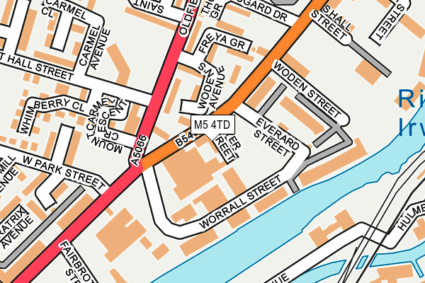
M5 4TD lies on Ordsall Lane in Salford. M5 4TD is located in the Ordsall electoral ward, within the metropolitan district of Salford and the English Parliamentary constituency of Salford and Eccles. The Sub Integrated Care Board (ICB) Location is NHS Greater Manchester ICB - 01G and the police force is Greater Manchester. This postcode has been in use since May 1994.


GetTheData
Source: OS OpenMap – Local (Ordnance Survey)
Source: OS VectorMap District (Ordnance Survey)
Licence: Open Government Licence (requires attribution)
| Easting | 382117 |
| Northing | 397355 |
| Latitude | 53.472637 |
| Longitude | -2.270882 |
GetTheData
Source: Open Postcode Geo
Licence: Open Government Licence
| Street | Ordsall Lane |
| Town/City | Salford |
| Country | England |
| Postcode District | M5 |
➜ See where M5 is on a map ➜ Where is Salford? | |
GetTheData
Source: Land Registry Price Paid Data
Licence: Open Government Licence
Elevation or altitude of M5 4TD as distance above sea level:
| Metres | Feet | |
|---|---|---|
| Elevation | 30m | 98ft |
Elevation is measured from the approximate centre of the postcode, to the nearest point on an OS contour line from OS Terrain 50, which has contour spacing of ten vertical metres.
➜ How high above sea level am I? Find the elevation of your current position using your device's GPS.
GetTheData
Source: Open Postcode Elevation
Licence: Open Government Licence
| Ward | Ordsall |
| Constituency | Salford And Eccles |
GetTheData
Source: ONS Postcode Database
Licence: Open Government Licence
221, ORDSALL LANE, SALFORD, M5 4TD 2005 18 JUL £500,000 |
221, ORDSALL LANE, SALFORD, M5 4TD 2004 4 NOV £400,000 |
221, ORDSALL LANE, SALFORD, M5 4TD 2003 8 OCT £200,000 |
GetTheData
Source: HM Land Registry Price Paid Data
Licence: Contains HM Land Registry data © Crown copyright and database right 2025. This data is licensed under the Open Government Licence v3.0.
| Ordsall Ln/Oldfield Rd (Ordsall Ln) | Ordsall | 22m |
| Oldfield Rd/Ordsall Ln (Oldfield Rd) | Ordsall | 60m |
| Robert Hall St/Welcome Inn (Robert Hall St) | Ordsall | 98m |
| Robert Hall St/Oldfield Rd (Robert Hall St) | Ordsall | 117m |
| Oldfield Rd/Robert Hall St (Oldfield Rd) | Ordsall | 197m |
| Cornbrook (Manchester Metrolink) | Cornbrook | 369m |
| Salford Quays (Manchester Metrolink) (St Peters Quay) | Salford Quays | 910m |
| Pomona (Manchester Metrolink) (Pomona Strand) | Salford Quays | 968m |
| Exchange Quay (Manchester Metrolink) (Exchange Quay) | Salford Quays | 980m |
| Anchorage (Manchester Metrolink) (Anchorage Quay) | Salford Quays | 1,033m |
| Deansgate Station | 1.3km |
| Salford Central Station | 1.6km |
| Salford Crescent Station | 1.6km |
GetTheData
Source: NaPTAN
Licence: Open Government Licence
GetTheData
Source: ONS Postcode Database
Licence: Open Government Licence


➜ Get more ratings from the Food Standards Agency
GetTheData
Source: Food Standards Agency
Licence: FSA terms & conditions
| Last Collection | |||
|---|---|---|---|
| Location | Mon-Fri | Sat | Distance |
| Sandiway | 17:30 | 11:45 | 268m |
| Pheobe Street | 17:30 | 11:45 | 460m |
| Chester Road/Hulme Hall Road | 17:30 | 12:00 | 557m |
GetTheData
Source: Dracos
Licence: Creative Commons Attribution-ShareAlike
The below table lists the International Territorial Level (ITL) codes (formerly Nomenclature of Territorial Units for Statistics (NUTS) codes) and Local Administrative Units (LAU) codes for M5 4TD:
| ITL 1 Code | Name |
|---|---|
| TLD | North West (England) |
| ITL 2 Code | Name |
| TLD3 | Greater Manchester |
| ITL 3 Code | Name |
| TLD34 | Greater Manchester South West |
| LAU 1 Code | Name |
| E08000006 | Salford |
GetTheData
Source: ONS Postcode Directory
Licence: Open Government Licence
The below table lists the Census Output Area (OA), Lower Layer Super Output Area (LSOA), and Middle Layer Super Output Area (MSOA) for M5 4TD:
| Code | Name | |
|---|---|---|
| OA | E00172949 | |
| LSOA | E01032915 | Salford 028I |
| MSOA | E02001184 | Salford 028 |
GetTheData
Source: ONS Postcode Directory
Licence: Open Government Licence
| M5 3WR | Bramble Avenue | 76m |
| M5 3NB | Ordsall Lane | 87m |
| M5 4TH | Worrall Street | 104m |
| M5 3NH | Wyatt Avenue | 108m |
| M5 3WL | Whimberry Close | 131m |
| M5 4TF | Wodens Avenue | 151m |
| M5 3LT | Robert Hall Street | 174m |
| M5 3LF | Cambridge Place | 178m |
| M5 3NF | Windmill Avenue | 193m |
| M5 3WW | West Park Street | 205m |
GetTheData
Source: Open Postcode Geo; Land Registry Price Paid Data
Licence: Open Government Licence