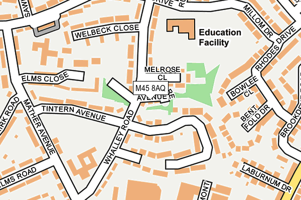
M45 8AQ is located in the Unsworth electoral ward, within the metropolitan district of Bury and the English Parliamentary constituency of Bury South. The Sub Integrated Care Board (ICB) Location is NHS Greater Manchester ICB - 00V and the police force is Greater Manchester. This postcode has been in use since March 2017.


GetTheData
Source: OS OpenMap – Local (Ordnance Survey)
Source: OS VectorMap District (Ordnance Survey)
Licence: Open Government Licence (requires attribution)
| Easting | 380988 |
| Northing | 406500 |
| Latitude | 53.554794 |
| Longitude | -2.288448 |
GetTheData
Source: Open Postcode Geo
Licence: Open Government Licence
| Country | England |
| Postcode District | M45 |
➜ See where M45 is on a map ➜ Where is Whitefield? | |
GetTheData
Source: Land Registry Price Paid Data
Licence: Open Government Licence
| Ward | Unsworth |
| Constituency | Bury South |
GetTheData
Source: ONS Postcode Database
Licence: Open Government Licence
| Stanley Rd/Mather Ave (Stanley Rd) | Whitefield | 228m |
| Stanley Rd/Mather Ave (Stanley Rd) | Whitefield | 246m |
| Stanley Rd/Parr Ln (Stanley Rd) | Whitefield | 311m |
| Stanley Rd/Moss Ln (Stanley Rd) | Hillock | 321m |
| Parr Ln/Moss Ln (Parr Ln) | Hillock | 337m |
| Whitefield (Manchester Metrolink) (Bury New Road) | Whitefield | 592m |
| Besses O'th'barn (Manchester Metrolink) (Off Bury Old Road) | Besses O Th Barn | 1,424m |
| Clifton (Manchester) Station | 4km |
| Swinton (Manchester) Station | 5.5km |
| Moorside Station | 6km |
GetTheData
Source: NaPTAN
Licence: Open Government Licence
| Percentage of properties with Next Generation Access | 100.0% |
| Percentage of properties with Superfast Broadband | 100.0% |
| Percentage of properties with Ultrafast Broadband | 100.0% |
| Percentage of properties with Full Fibre Broadband | 0.0% |
Superfast Broadband is between 30Mbps and 300Mbps
Ultrafast Broadband is > 300Mbps
| Percentage of properties unable to receive 2Mbps | 0.0% |
| Percentage of properties unable to receive 5Mbps | 0.0% |
| Percentage of properties unable to receive 10Mbps | 0.0% |
| Percentage of properties unable to receive 30Mbps | 0.0% |
GetTheData
Source: Ofcom
Licence: Ofcom Terms of Use (requires attribution)
GetTheData
Source: ONS Postcode Database
Licence: Open Government Licence


➜ Get more ratings from the Food Standards Agency
GetTheData
Source: Food Standards Agency
Licence: FSA terms & conditions
| Last Collection | |||
|---|---|---|---|
| Location | Mon-Fri | Sat | Distance |
| Whitefield Station | 17:30 | 12:00 | 227m |
| Swinton Crescent | 17:40 | 11:05 | 359m |
| 135 Randale Drive | 17:40 | 11:00 | 386m |
GetTheData
Source: Dracos
Licence: Creative Commons Attribution-ShareAlike
The below table lists the International Territorial Level (ITL) codes (formerly Nomenclature of Territorial Units for Statistics (NUTS) codes) and Local Administrative Units (LAU) codes for M45 8AQ:
| ITL 1 Code | Name |
|---|---|
| TLD | North West (England) |
| ITL 2 Code | Name |
| TLD3 | Greater Manchester |
| ITL 3 Code | Name |
| TLD37 | Greater Manchester North East |
| LAU 1 Code | Name |
| E08000002 | Bury |
GetTheData
Source: ONS Postcode Directory
Licence: Open Government Licence
The below table lists the Census Output Area (OA), Lower Layer Super Output Area (LSOA), and Middle Layer Super Output Area (MSOA) for M45 8AQ:
| Code | Name | |
|---|---|---|
| OA | E00025234 | |
| LSOA | E01004988 | Bury 020D |
| MSOA | E02001038 | Bury 020 |
GetTheData
Source: ONS Postcode Directory
Licence: Open Government Licence
| M45 8XZ | Melrose Close | 71m |
| M45 8WY | Tintern Avenue | 87m |
| M45 8PA | Whalley Road | 102m |
| M45 8WZ | Whalley Road | 104m |
| M45 8NZ | Whalley Close | 106m |
| BL9 8NQ | Bowlee Close | 146m |
| M45 8NY | Tintern Avenue | 157m |
| M45 8UZ | Whalley Road | 172m |
| BL9 8NG | Bent Fold Drive | 179m |
| M45 8PB | Welbeck Close | 203m |
GetTheData
Source: Open Postcode Geo; Land Registry Price Paid Data
Licence: Open Government Licence