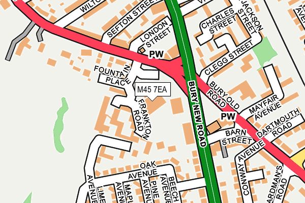
M45 7EA is located in the Pilkington Park electoral ward, within the metropolitan district of Bury and the English Parliamentary constituency of Bury South. The Sub Integrated Care Board (ICB) Location is NHS Greater Manchester ICB - 00V and the police force is Greater Manchester. This postcode has been in use since May 1994.


GetTheData
Source: OS OpenMap – Local (Ordnance Survey)
Source: OS VectorMap District (Ordnance Survey)
Licence: Open Government Licence (requires attribution)
| Easting | 380745 |
| Northing | 405208 |
| Latitude | 53.543172 |
| Longitude | -2.292035 |
GetTheData
Source: Open Postcode Geo
Licence: Open Government Licence
| Country | England |
| Postcode District | M45 |
➜ See where M45 is on a map ➜ Where is Whitefield? | |
GetTheData
Source: Land Registry Price Paid Data
Licence: Open Government Licence
Elevation or altitude of M45 7EA as distance above sea level:
| Metres | Feet | |
|---|---|---|
| Elevation | 110m | 361ft |
Elevation is measured from the approximate centre of the postcode, to the nearest point on an OS contour line from OS Terrain 50, which has contour spacing of ten vertical metres.
➜ How high above sea level am I? Find the elevation of your current position using your device's GPS.
GetTheData
Source: Open Postcode Elevation
Licence: Open Government Licence
| Ward | Pilkington Park |
| Constituency | Bury South |
GetTheData
Source: ONS Postcode Database
Licence: Open Government Licence
| Higher Ln/Bury New Rd (Higher Ln) | Besses O Th Barn | 97m |
| Bury New Rd/Besses Junction (Bury New Rd) | Besses O Th Barn | 109m |
| Higher Ln/Fountain Pl (Higher Ln) | Besses O Th Barn | 161m |
| Bury Old Rd/Mayfair Ave (Bury Old Rd) | Besses O Th Barn | 163m |
| Bury New Rd/Sefton St (Bury New Rd) | Besses O Th Barn | 204m |
| Besses O'th'barn (Manchester Metrolink) (Off Bury Old Road) | Besses O Th Barn | 409m |
| Whitefield (Manchester Metrolink) (Bury New Road) | Whitefield | 924m |
| Prestwich (Manchester Metrolink) (Off Fairfax Road) | Prestwich | 1,278m |
| Clifton (Manchester) Station | 2.7km |
| Swinton (Manchester) Station | 4.4km |
| Moorside Station | 5km |
GetTheData
Source: NaPTAN
Licence: Open Government Licence
GetTheData
Source: ONS Postcode Database
Licence: Open Government Licence


➜ Get more ratings from the Food Standards Agency
GetTheData
Source: Food Standards Agency
Licence: FSA terms & conditions
| Last Collection | |||
|---|---|---|---|
| Location | Mon-Fri | Sat | Distance |
| 279a Bury New Road | 17:30 | 12:00 | 221m |
| Kenmore Road | 17:30 | 11:45 | 473m |
| Kirkhams | 17:30 | 11:45 | 689m |
GetTheData
Source: Dracos
Licence: Creative Commons Attribution-ShareAlike
The below table lists the International Territorial Level (ITL) codes (formerly Nomenclature of Territorial Units for Statistics (NUTS) codes) and Local Administrative Units (LAU) codes for M45 7EA:
| ITL 1 Code | Name |
|---|---|
| TLD | North West (England) |
| ITL 2 Code | Name |
| TLD3 | Greater Manchester |
| ITL 3 Code | Name |
| TLD37 | Greater Manchester North East |
| LAU 1 Code | Name |
| E08000002 | Bury |
GetTheData
Source: ONS Postcode Directory
Licence: Open Government Licence
The below table lists the Census Output Area (OA), Lower Layer Super Output Area (LSOA), and Middle Layer Super Output Area (MSOA) for M45 7EA:
| Code | Name | |
|---|---|---|
| OA | E00025228 | |
| LSOA | E01004986 | Bury 020B |
| MSOA | E02001038 | Bury 020 |
GetTheData
Source: ONS Postcode Directory
Licence: Open Government Licence
| M45 7FB | Frankton Road | 43m |
| M45 7FA | Top O Th Fields | 86m |
| M45 7FG | Fountain Place | 94m |
| M45 7HD | Needham Court | 96m |
| M45 7HG | Higher Lane | 111m |
| M45 7FN | Oak Avenue | 122m |
| M45 7ES | London Street | 127m |
| M45 7HA | Phillips Place | 129m |
| M45 7EG | Bury New Road | 132m |
| M45 6BN | Charles Walk | 146m |
GetTheData
Source: Open Postcode Geo; Land Registry Price Paid Data
Licence: Open Government Licence