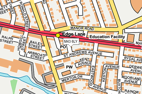
M43 6LY is located in the Droylsden East electoral ward, within the metropolitan district of Tameside and the English Parliamentary constituency of Ashton-under-Lyne. The Sub Integrated Care Board (ICB) Location is NHS Greater Manchester ICB - 01Y and the police force is Greater Manchester. This postcode has been in use since March 2017.


GetTheData
Source: OS OpenMap – Local (Ordnance Survey)
Source: OS VectorMap District (Ordnance Survey)
Licence: Open Government Licence (requires attribution)
| Easting | 389161 |
| Northing | 398203 |
| Latitude | 53.480452 |
| Longitude | -2.164791 |
GetTheData
Source: Open Postcode Geo
Licence: Open Government Licence
| Country | England |
| Postcode District | M43 |
➜ See where M43 is on a map ➜ Where is Droylsden? | |
GetTheData
Source: Land Registry Price Paid Data
Licence: Open Government Licence
| Ward | Droylsden East |
| Constituency | Ashton-under-lyne |
GetTheData
Source: ONS Postcode Database
Licence: Open Government Licence
| Edge Lane Tram Stop (Manchester Road) | Droylsden | 37m |
| Edge Lane Tram Stop (Manchester Road) | Droylsden | 63m |
| Edge Lane Tram Stop (Manchester Rd) | Droylsden | 69m |
| Edge Ln/Manchester Rd (Edge Ln) | Droylsden | 94m |
| Manchester Rd/Buxton Ln (Manchester Rd) | Droylsden | 158m |
| Edge Lane (Manchester Metrolink) (Manchester Road) | Droylsden | 54m |
| Cemetery Road (Manchester Metrolink) (Manchester Road) | Droylsden | 652m |
| Clayton Hall (Manchester Metrolink) (Ashton New Road) | Clayton | 1,182m |
| Droylsden (Manchester Metrolink) (Ashton Road) | Droylsden | 1,340m |
| Gorton Station | 1.3km |
| Fairfield Station | 1.6km |
| Ashburys Station | 2.2km |
GetTheData
Source: NaPTAN
Licence: Open Government Licence
GetTheData
Source: ONS Postcode Database
Licence: Open Government Licence


➜ Get more ratings from the Food Standards Agency
GetTheData
Source: Food Standards Agency
Licence: FSA terms & conditions
| Last Collection | |||
|---|---|---|---|
| Location | Mon-Fri | Sat | Distance |
| Opp 123 Sandywell Street | 17:30 | 12:00 | 548m |
| 120 Lumb Lane | 17:30 | 12:00 | 566m |
| 42 Wheeler Street | 17:30 | 12:00 | 622m |
GetTheData
Source: Dracos
Licence: Creative Commons Attribution-ShareAlike
The below table lists the International Territorial Level (ITL) codes (formerly Nomenclature of Territorial Units for Statistics (NUTS) codes) and Local Administrative Units (LAU) codes for M43 6LY:
| ITL 1 Code | Name |
|---|---|
| TLD | North West (England) |
| ITL 2 Code | Name |
| TLD3 | Greater Manchester |
| ITL 3 Code | Name |
| TLD35 | Greater Manchester South East |
| LAU 1 Code | Name |
| E08000008 | Tameside |
GetTheData
Source: ONS Postcode Directory
Licence: Open Government Licence
The below table lists the Census Output Area (OA), Lower Layer Super Output Area (LSOA), and Middle Layer Super Output Area (MSOA) for M43 6LY:
| Code | Name | |
|---|---|---|
| OA | E00030357 | |
| LSOA | E01005998 | Tameside 012A |
| MSOA | E02001240 | Tameside 012 |
GetTheData
Source: ONS Postcode Directory
Licence: Open Government Licence
| M43 6QF | Manchester Road | 26m |
| M43 6BP | St Andrews Avenue | 47m |
| M43 6BW | Kent Avenue | 67m |
| M43 6BG | Edge Lane | 87m |
| M43 6BS | Edge Lane | 109m |
| M43 6JD | Manor Road | 109m |
| M43 6JA | Manor Road | 121m |
| M43 6QX | Manchester Road | 134m |
| M43 6BH | Merton Drive | 142m |
| M43 6BN | Eastwood Avenue | 147m |
GetTheData
Source: Open Postcode Geo; Land Registry Price Paid Data
Licence: Open Government Licence