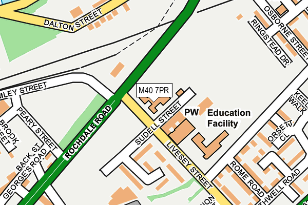
M40 7PR is located in the Miles Platting & Newton Heath electoral ward, within the metropolitan district of Manchester and the English Parliamentary constituency of Manchester Central. The Sub Integrated Care Board (ICB) Location is NHS Greater Manchester ICB - 14L and the police force is Greater Manchester. This postcode has been in use since May 1994.


GetTheData
Source: OS OpenMap – Local (Ordnance Survey)
Source: OS VectorMap District (Ordnance Survey)
Licence: Open Government Licence (requires attribution)
| Easting | 385042 |
| Northing | 399358 |
| Latitude | 53.490715 |
| Longitude | -2.226913 |
GetTheData
Source: Open Postcode Geo
Licence: Open Government Licence
| Country | England |
| Postcode District | M40 |
➜ See where M40 is on a map ➜ Where is Manchester? | |
GetTheData
Source: Land Registry Price Paid Data
Licence: Open Government Licence
Elevation or altitude of M40 7PR as distance above sea level:
| Metres | Feet | |
|---|---|---|
| Elevation | 50m | 164ft |
Elevation is measured from the approximate centre of the postcode, to the nearest point on an OS contour line from OS Terrain 50, which has contour spacing of ten vertical metres.
➜ How high above sea level am I? Find the elevation of your current position using your device's GPS.
GetTheData
Source: Open Postcode Elevation
Licence: Open Government Licence
| Ward | Miles Platting & Newton Heath |
| Constituency | Manchester Central |
GetTheData
Source: ONS Postcode Database
Licence: Open Government Licence
| Rochdale Rd/Livesey St (Rochdale Rd) | Newtown | 87m |
| Rochdale Rd/Livesey St (Rochdale Rd) | Newtown | 117m |
| Rochdale Rd/Peary St (Rochdale Rd) | Newtown | 165m |
| Rochdale Rd/Osborne St (Rochdale Rd) | Newtown | 261m |
| Rochdale Rd/Moorhead St (Rochdale Rd) | Newtown | 295m |
| Shudehill (Manchester Metrolink) (Shudehill) | Manchester City Centre | 1,018m |
| Victoria (Manchester Metrolink) (Off Corporation Street) | Manchester City Centre | 1,073m |
| New Islington (Manchester Metrolink) (Pollard Street) | New Islington | 1,173m |
| Queens Road (Manchester Metrolink) (Queens Road) | Smedley | 1,221m |
| Exchange Square (Manchester Metrolink) (Corporation St) | Manchester City Centre | 1,257m |
| Manchester Victoria Station | 1.1km |
| Manchester Piccadilly Station | 1.5km |
| Salford Central Station | 2km |
GetTheData
Source: NaPTAN
Licence: Open Government Licence
GetTheData
Source: ONS Postcode Database
Licence: Open Government Licence


➜ Get more ratings from the Food Standards Agency
GetTheData
Source: Food Standards Agency
Licence: FSA terms & conditions
| Last Collection | |||
|---|---|---|---|
| Location | Mon-Fri | Sat | Distance |
| Sudell Street, In Wall Lms | 19:00 | 12:00 | 303m |
| Manchester Apc | 19:30 | 345m | |
| Royal Mail 77 Oldham Road | 19:30 | 17:00 | 349m |
GetTheData
Source: Dracos
Licence: Creative Commons Attribution-ShareAlike
The below table lists the International Territorial Level (ITL) codes (formerly Nomenclature of Territorial Units for Statistics (NUTS) codes) and Local Administrative Units (LAU) codes for M40 7PR:
| ITL 1 Code | Name |
|---|---|
| TLD | North West (England) |
| ITL 2 Code | Name |
| TLD3 | Greater Manchester |
| ITL 3 Code | Name |
| TLD33 | Manchester |
| LAU 1 Code | Name |
| E08000003 | Manchester |
GetTheData
Source: ONS Postcode Directory
Licence: Open Government Licence
The below table lists the Census Output Area (OA), Lower Layer Super Output Area (LSOA), and Middle Layer Super Output Area (MSOA) for M40 7PR:
| Code | Name | |
|---|---|---|
| OA | E00025953 | |
| LSOA | E01005130 | Manchester 054A |
| MSOA | E02006902 | Manchester 054 |
GetTheData
Source: ONS Postcode Directory
Licence: Open Government Licence
| M4 4JF | Sudell Street | 99m |
| M4 4JG | Shilford Drive | 133m |
| M4 5HF | Livesey Street | 162m |
| M40 7GS | Dalton Street | 186m |
| M40 7GX | Dalton Street | 224m |
| M40 7GY | Davy Street | 225m |
| M40 7UB | Oakford Avenue | 227m |
| M40 7EB | Dalton Street | 233m |
| M40 7ED | Dalton Street | 249m |
| M40 7PD | Reather Walk | 257m |
GetTheData
Source: Open Postcode Geo; Land Registry Price Paid Data
Licence: Open Government Licence