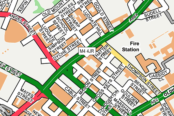
M4 4JR lies on Rochdale Road in Manchester. M4 4JR is located in the Piccadilly electoral ward, within the metropolitan district of Manchester and the English Parliamentary constituency of Manchester Central. The Sub Integrated Care Board (ICB) Location is NHS Greater Manchester ICB - 14L and the police force is Greater Manchester. This postcode has been in use since January 1980.


GetTheData
Source: OS OpenMap – Local (Ordnance Survey)
Source: OS VectorMap District (Ordnance Survey)
Licence: Open Government Licence (requires attribution)
| Easting | 384592 |
| Northing | 398975 |
| Latitude | 53.487276 |
| Longitude | -2.233674 |
GetTheData
Source: Open Postcode Geo
Licence: Open Government Licence
| Street | Rochdale Road |
| Town/City | Manchester |
| Country | England |
| Postcode District | M4 |
➜ See where M4 is on a map ➜ Where is Manchester? | |
GetTheData
Source: Land Registry Price Paid Data
Licence: Open Government Licence
Elevation or altitude of M4 4JR as distance above sea level:
| Metres | Feet | |
|---|---|---|
| Elevation | 50m | 164ft |
Elevation is measured from the approximate centre of the postcode, to the nearest point on an OS contour line from OS Terrain 50, which has contour spacing of ten vertical metres.
➜ How high above sea level am I? Find the elevation of your current position using your device's GPS.
GetTheData
Source: Open Postcode Elevation
Licence: Open Government Licence
| Ward | Piccadilly |
| Constituency | Manchester Central |
GetTheData
Source: ONS Postcode Database
Licence: Open Government Licence
| Rochdale Rd/Thompson St (Rochdale Rd) | Newtown | 17m |
| Rochdale Rd/Angel St (Rochdale Rd) | Newtown | 46m |
| Thompson St/Rochdale Rd (Thompson St) | Newtown | 102m |
| Rochdale Rd/Gould St (Rochdale Rd) | Newtown | 154m |
| Thompson St/Oldham Rd (Thompson St) | Ancoats | 222m |
| Shudehill (Manchester Metrolink) (Shudehill) | Manchester City Centre | 427m |
| Victoria (Manchester Metrolink) (Off Corporation Street) | Manchester City Centre | 556m |
| Exchange Square (Manchester Metrolink) (Corporation St) | Manchester City Centre | 674m |
| Market Street (Manchester Metrolink) (Market Street) | Manchester City Centre | 695m |
| Piccadilly Gardens (Manchester Metrolink) (Portland Street) | Piccadilly Gardens | 824m |
| Manchester Victoria Station | 0.6km |
| Manchester Piccadilly Station | 1.1km |
| Salford Central Station | 1.5km |
GetTheData
Source: NaPTAN
Licence: Open Government Licence
GetTheData
Source: ONS Postcode Database
Licence: Open Government Licence


➜ Get more ratings from the Food Standards Agency
GetTheData
Source: Food Standards Agency
Licence: FSA terms & conditions
| Last Collection | |||
|---|---|---|---|
| Location | Mon-Fri | Sat | Distance |
| Shudehill | 19:00 | 12:00 | 191m |
| New Cross | 19:00 | 12:00 | 270m |
| Sudell Street, In Wall Lms | 19:00 | 12:00 | 301m |
GetTheData
Source: Dracos
Licence: Creative Commons Attribution-ShareAlike
The below table lists the International Territorial Level (ITL) codes (formerly Nomenclature of Territorial Units for Statistics (NUTS) codes) and Local Administrative Units (LAU) codes for M4 4JR:
| ITL 1 Code | Name |
|---|---|
| TLD | North West (England) |
| ITL 2 Code | Name |
| TLD3 | Greater Manchester |
| ITL 3 Code | Name |
| TLD33 | Manchester |
| LAU 1 Code | Name |
| E08000003 | Manchester |
GetTheData
Source: ONS Postcode Directory
Licence: Open Government Licence
The below table lists the Census Output Area (OA), Lower Layer Super Output Area (LSOA), and Middle Layer Super Output Area (MSOA) for M4 4JR:
| Code | Name | |
|---|---|---|
| OA | E00175853 | |
| LSOA | E01033651 | Manchester 054B |
| MSOA | E02006902 | Manchester 054 |
GetTheData
Source: ONS Postcode Directory
Licence: Open Government Licence
| M4 5EH | Goulden Street | 9m |
| M4 5EJ | Goulden Street | 9m |
| M4 5EN | Goulden Street | 28m |
| M4 5FX | Mason Street | 49m |
| M4 5EZ | Mason Street | 73m |
| M4 4BU | Dyche Street | 82m |
| M4 4DS | Dyche Street | 82m |
| M4 4TG | Ludgate Hill | 101m |
| M4 4TJ | Ludgate Hill | 101m |
| M4 4BW | Ludgate Hill | 108m |
GetTheData
Source: Open Postcode Geo; Land Registry Price Paid Data
Licence: Open Government Licence