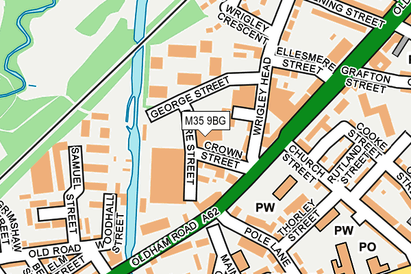
M35 9BG is located in the Failsworth East electoral ward, within the metropolitan district of Oldham and the English Parliamentary constituency of Ashton-under-Lyne. The Sub Integrated Care Board (ICB) Location is NHS Greater Manchester ICB - 00Y and the police force is Greater Manchester. This postcode has been in use since June 1999.


GetTheData
Source: OS OpenMap – Local (Ordnance Survey)
Source: OS VectorMap District (Ordnance Survey)
Licence: Open Government Licence (requires attribution)
| Easting | 389666 |
| Northing | 401719 |
| Latitude | 53.512065 |
| Longitude | -2.157298 |
GetTheData
Source: Open Postcode Geo
Licence: Open Government Licence
| Country | England |
| Postcode District | M35 |
➜ See where M35 is on a map ➜ Where is Failsworth? | |
GetTheData
Source: Land Registry Price Paid Data
Licence: Open Government Licence
Elevation or altitude of M35 9BG as distance above sea level:
| Metres | Feet | |
|---|---|---|
| Elevation | 100m | 328ft |
Elevation is measured from the approximate centre of the postcode, to the nearest point on an OS contour line from OS Terrain 50, which has contour spacing of ten vertical metres.
➜ How high above sea level am I? Find the elevation of your current position using your device's GPS.
GetTheData
Source: Open Postcode Elevation
Licence: Open Government Licence
| Ward | Failsworth East |
| Constituency | Ashton-under-lyne |
GetTheData
Source: ONS Postcode Database
Licence: Open Government Licence
| Oldham Rd/Failsworth Pole (Oldham Rd) | Failsworth | 103m |
| Oldham Rd/Failsworth Pole (Oldham Rd) | Failsworth | 126m |
| Woodall Street | Failsworth | 161m |
| Oldham Rd/Failsworth Precinct (Oldham Rd) | Failsworth | 262m |
| Ashton Rd West/Henry St (Ashton Rd West) | Failsworth | 346m |
| Failsworth (Manchester Metrolink) (Hardman Lane) | Failsworth | 407m |
| Hollinwood (Manchester Metrolink) (Railway Road) | Hollinwood | 1,082m |
| Moston Station | 1.6km |
| Mills Hill (Manchester) Station | 4.5km |
| Fairfield Station | 4.6km |
GetTheData
Source: NaPTAN
Licence: Open Government Licence
| Median download speed | 70.2Mbps |
| Average download speed | 49.6Mbps |
| Maximum download speed | 80.00Mbps |
| Median upload speed | 20.0Mbps |
| Average upload speed | 12.5Mbps |
| Maximum upload speed | 20.00Mbps |
GetTheData
Source: Ofcom
Licence: Ofcom Terms of Use (requires attribution)
GetTheData
Source: ONS Postcode Database
Licence: Open Government Licence

➜ Get more ratings from the Food Standards Agency
GetTheData
Source: Food Standards Agency
Licence: FSA terms & conditions
| Last Collection | |||
|---|---|---|---|
| Location | Mon-Fri | Sat | Distance |
| Morrisons | 17:40 | 12:00 | 1,012m |
| Delmahoy Close | 17:30 | 12:00 | 1,220m |
| Corner Of Chapel Road | 17:30 | 11:55 | 1,802m |
GetTheData
Source: Dracos
Licence: Creative Commons Attribution-ShareAlike
The below table lists the International Territorial Level (ITL) codes (formerly Nomenclature of Territorial Units for Statistics (NUTS) codes) and Local Administrative Units (LAU) codes for M35 9BG:
| ITL 1 Code | Name |
|---|---|
| TLD | North West (England) |
| ITL 2 Code | Name |
| TLD3 | Greater Manchester |
| ITL 3 Code | Name |
| TLD37 | Greater Manchester North East |
| LAU 1 Code | Name |
| E08000004 | Oldham |
GetTheData
Source: ONS Postcode Directory
Licence: Open Government Licence
The below table lists the Census Output Area (OA), Lower Layer Super Output Area (LSOA), and Middle Layer Super Output Area (MSOA) for M35 9BG:
| Code | Name | |
|---|---|---|
| OA | E00027175 | |
| LSOA | E01005363 | Oldham 032A |
| MSOA | E02001129 | Oldham 032 |
GetTheData
Source: ONS Postcode Directory
Licence: Open Government Licence
| M35 9BD | Crown Street | 52m |
| M35 0AA | Oldham Road | 87m |
| M35 0DE | Samuel Street | 100m |
| M35 9BZ | Edmund Street | 118m |
| M35 9BW | Crown Business Centre | 124m |
| M35 0FH | Oldham Road | 128m |
| M35 9BS | Wrigley Head | 170m |
| M35 9QY | Ben Brierley Wharf | 172m |
| M35 0GB | Springfield Close | 173m |
| M35 0GD | Old Road | 192m |
GetTheData
Source: Open Postcode Geo; Land Registry Price Paid Data
Licence: Open Government Licence