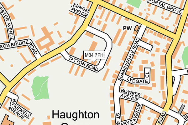
M34 7PH is located in the Denton South electoral ward, within the metropolitan district of Tameside and the English Parliamentary constituency of Denton and Reddish. The Sub Integrated Care Board (ICB) Location is NHS Greater Manchester ICB - 01Y and the police force is Greater Manchester. This postcode has been in use since May 1994.


GetTheData
Source: OS OpenMap – Local (Ordnance Survey)
Source: OS VectorMap District (Ordnance Survey)
Licence: Open Government Licence (requires attribution)
| Easting | 393403 |
| Northing | 394085 |
| Latitude | 53.443492 |
| Longitude | -2.100785 |
GetTheData
Source: Open Postcode Geo
Licence: Open Government Licence
| Country | England |
| Postcode District | M34 |
➜ See where M34 is on a map ➜ Where is Denton? | |
GetTheData
Source: Land Registry Price Paid Data
Licence: Open Government Licence
Elevation or altitude of M34 7PH as distance above sea level:
| Metres | Feet | |
|---|---|---|
| Elevation | 110m | 361ft |
Elevation is measured from the approximate centre of the postcode, to the nearest point on an OS contour line from OS Terrain 50, which has contour spacing of ten vertical metres.
➜ How high above sea level am I? Find the elevation of your current position using your device's GPS.
GetTheData
Source: Open Postcode Elevation
Licence: Open Government Licence
| Ward | Denton South |
| Constituency | Denton And Reddish |
GetTheData
Source: ONS Postcode Database
Licence: Open Government Licence
| Mancunian Rd/Library (Mancunian Rd) | Haughton Green | 117m |
| Mancunian Rd/Trowbridge Rd (Mancunian Rd) | Haughton Green | 147m |
| Mancunian Rd/Trowbridge Rd (Mancunian Rd) | Haughton Green | 176m |
| Two Trees Ln/Chapel House (Two Trees Ln) | Haughton Green | 185m |
| Two Trees Ln/Chapel House (Two Trees Ln) | Haughton Green | 193m |
| Hyde Central Station | 1.4km |
| Woodley Station | 1.7km |
| Bredbury Station | 2.4km |
GetTheData
Source: NaPTAN
Licence: Open Government Licence
GetTheData
Source: ONS Postcode Database
Licence: Open Government Licence


➜ Get more ratings from the Food Standards Agency
GetTheData
Source: Food Standards Agency
Licence: FSA terms & conditions
| Last Collection | |||
|---|---|---|---|
| Location | Mon-Fri | Sat | Distance |
| 289 Manchester Road | 17:30 | 12:00 | 162m |
| Cardinal Street | 17:30 | 11:45 | 793m |
| Castle Hill | 16:00 | 11:30 | 1,290m |
GetTheData
Source: Dracos
Licence: Creative Commons Attribution-ShareAlike
The below table lists the International Territorial Level (ITL) codes (formerly Nomenclature of Territorial Units for Statistics (NUTS) codes) and Local Administrative Units (LAU) codes for M34 7PH:
| ITL 1 Code | Name |
|---|---|
| TLD | North West (England) |
| ITL 2 Code | Name |
| TLD3 | Greater Manchester |
| ITL 3 Code | Name |
| TLD35 | Greater Manchester South East |
| LAU 1 Code | Name |
| E08000008 | Tameside |
GetTheData
Source: ONS Postcode Directory
Licence: Open Government Licence
The below table lists the Census Output Area (OA), Lower Layer Super Output Area (LSOA), and Middle Layer Super Output Area (MSOA) for M34 7PH:
| Code | Name | |
|---|---|---|
| OA | E00030283 | |
| LSOA | E01005980 | Tameside 029B |
| MSOA | E02001257 | Tameside 029 |
GetTheData
Source: ONS Postcode Directory
Licence: Open Government Licence
| M34 7PL | Tatton Road | 40m |
| M34 7EL | Haddon Way | 50m |
| M34 7EB | Thorsby Way | 61m |
| M34 7GP | Sunningdale Road | 97m |
| M34 7QP | Sunningdale Road | 115m |
| M34 7EJ | Penshurst Walk | 127m |
| M34 7GX | Mancunian Road | 132m |
| M34 7EG | Adlington Way | 152m |
| M34 7EF | Holker Way | 160m |
| M34 7GW | Lydgate Close | 160m |
GetTheData
Source: Open Postcode Geo; Land Registry Price Paid Data
Licence: Open Government Licence