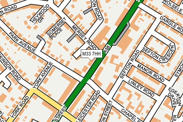
M33 7HH lies on Cross Street in Sale. M33 7HH is located in the Ashton upon Mersey electoral ward, within the metropolitan district of Trafford and the English Parliamentary constituency of Altrincham and Sale West. The Sub Integrated Care Board (ICB) Location is NHS Greater Manchester ICB - 02A and the police force is Greater Manchester. This postcode has been in use since May 1994.


GetTheData
Source: OS OpenMap – Local (Ordnance Survey)
Source: OS VectorMap District (Ordnance Survey)
Licence: Open Government Licence (requires attribution)
| Easting | 378700 |
| Northing | 392483 |
| Latitude | 53.428701 |
| Longitude | -2.322029 |
GetTheData
Source: Open Postcode Geo
Licence: Open Government Licence
| Street | Cross Street |
| Town/City | Sale |
| Country | England |
| Postcode District | M33 |
➜ See where M33 is on a map ➜ Where is Sale? | |
GetTheData
Source: Land Registry Price Paid Data
Licence: Open Government Licence
Elevation or altitude of M33 7HH as distance above sea level:
| Metres | Feet | |
|---|---|---|
| Elevation | 20m | 66ft |
Elevation is measured from the approximate centre of the postcode, to the nearest point on an OS contour line from OS Terrain 50, which has contour spacing of ten vertical metres.
➜ How high above sea level am I? Find the elevation of your current position using your device's GPS.
GetTheData
Source: Open Postcode Elevation
Licence: Open Government Licence
| Ward | Ashton Upon Mersey |
| Constituency | Altrincham And Sale West |
GetTheData
Source: ONS Postcode Database
Licence: Open Government Licence
DUNHAM HOUSE, CROSS STREET, SALE, M33 7HH 1998 19 JAN £100,305 |
GetTheData
Source: HM Land Registry Price Paid Data
Licence: Contains HM Land Registry data © Crown copyright and database right 2025. This data is licensed under the Open Government Licence v3.0.
| Cross Street/Chapel Road (Cross Street) | Sale | 27m |
| Cross Street/Ashfield Road (Cross Street) | Sale | 123m |
| Cross Street/Ashfield Road (Cross Street) | Sale | 136m |
| Cross Street/Mersey Road (Cross Street) | Sale | 145m |
| Ashfield Road/Cross Street (Ashfield Road) | Sale | 193m |
| Sale (Manchester Metrolink) (Off School Road) | Sale | 533m |
| Dane Road (Manchester Metrolink) (Dane Road) | Sale | 729m |
| Brooklands (Manchester Metrolink) (Brooklands Road) | Brooklands | 1,286m |
| Humphrey Park Station | 2.6km |
| Trafford Park Station | 3km |
| Urmston Station | 3km |
GetTheData
Source: NaPTAN
Licence: Open Government Licence
| Median download speed | 80.0Mbps |
| Average download speed | 66.6Mbps |
| Maximum download speed | 80.00Mbps |
| Median upload speed | 20.0Mbps |
| Average upload speed | 14.5Mbps |
| Maximum upload speed | 20.00Mbps |
GetTheData
Source: Ofcom
Licence: Ofcom Terms of Use (requires attribution)
GetTheData
Source: ONS Postcode Database
Licence: Open Government Licence


➜ Get more ratings from the Food Standards Agency
GetTheData
Source: Food Standards Agency
Licence: FSA terms & conditions
| Last Collection | |||
|---|---|---|---|
| Location | Mon-Fri | Sat | Distance |
| Cross Street P.o. | 17:30 | 12:00 | 166m |
| Sainsbury's | 17:30 | 12:00 | 299m |
| 29 Glebelands Road | 17:30 | 12:00 | 339m |
GetTheData
Source: Dracos
Licence: Creative Commons Attribution-ShareAlike
The below table lists the International Territorial Level (ITL) codes (formerly Nomenclature of Territorial Units for Statistics (NUTS) codes) and Local Administrative Units (LAU) codes for M33 7HH:
| ITL 1 Code | Name |
|---|---|
| TLD | North West (England) |
| ITL 2 Code | Name |
| TLD3 | Greater Manchester |
| ITL 3 Code | Name |
| TLD34 | Greater Manchester South West |
| LAU 1 Code | Name |
| E08000009 | Trafford |
GetTheData
Source: ONS Postcode Directory
Licence: Open Government Licence
The below table lists the Census Output Area (OA), Lower Layer Super Output Area (LSOA), and Middle Layer Super Output Area (MSOA) for M33 7HH:
| Code | Name | |
|---|---|---|
| OA | E00031160 | |
| LSOA | E01006149 | Trafford 012B |
| MSOA | E02001270 | Trafford 012 |
GetTheData
Source: ONS Postcode Directory
Licence: Open Government Licence
| M33 7AW | Cross Street | 53m |
| M33 6HH | Arnside Grove | 65m |
| M33 7JN | Cross Street | 69m |
| M33 7LD | Russell Place | 81m |
| M33 6HL | Mersey Road | 89m |
| M33 6HF | Dane Mews | 114m |
| M33 7FH | Sefton Road | 130m |
| M33 7DH | Chapel Road | 133m |
| M33 7HF | Cross Street | 137m |
| M33 7AN | Cross Street | 137m |
GetTheData
Source: Open Postcode Geo; Land Registry Price Paid Data
Licence: Open Government Licence