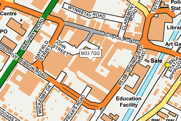
M33 7GG is located in the Sale Central electoral ward, within the metropolitan district of Trafford and the English Parliamentary constituency of Wythenshawe and Sale East. The Sub Integrated Care Board (ICB) Location is NHS Greater Manchester ICB - 02A and the police force is Greater Manchester. This postcode has been in use since March 2017.


GetTheData
Source: OS OpenMap – Local (Ordnance Survey)
Source: OS VectorMap District (Ordnance Survey)
Licence: Open Government Licence (requires attribution)
| Easting | 378639 |
| Northing | 391997 |
| Latitude | 53.424346 |
| Longitude | -2.322914 |
GetTheData
Source: Open Postcode Geo
Licence: Open Government Licence
| Country | England |
| Postcode District | M33 |
➜ See where M33 is on a map ➜ Where is Sale? | |
GetTheData
Source: Land Registry Price Paid Data
Licence: Open Government Licence
| Ward | Sale Central |
| Constituency | Wythenshawe And Sale East |
GetTheData
Source: ONS Postcode Database
Licence: Open Government Licence
| Sibson Road/Friars Court (Sibson Road) | Sale | 118m |
| Springfield Road/Market (Springfield Rd) | Sale | 123m |
| Hayfield St/John St (Hayfield Street) | Sale | 138m |
| Springfield Road/Market (Springfield Rd) | Sale | 138m |
| Hayfield St/John St (Hayfield Street) | Sale | 139m |
| Sale (Manchester Metrolink) (Off School Road) | Sale | 251m |
| Brooklands (Manchester Metrolink) (Brooklands Road) | Brooklands | 798m |
| Dane Road (Manchester Metrolink) (Dane Road) | Sale | 1,013m |
| Humphrey Park Station | 3.1km |
| Urmston Station | 3.4km |
| Trafford Park Station | 3.5km |
GetTheData
Source: NaPTAN
Licence: Open Government Licence
| Percentage of properties with Next Generation Access | 100.0% |
| Percentage of properties with Superfast Broadband | 100.0% |
| Percentage of properties with Ultrafast Broadband | 100.0% |
| Percentage of properties with Full Fibre Broadband | 100.0% |
Superfast Broadband is between 30Mbps and 300Mbps
Ultrafast Broadband is > 300Mbps
| Median download speed | 40.0Mbps |
| Average download speed | 40.1Mbps |
| Maximum download speed | 68.26Mbps |
| Median upload speed | 9.8Mbps |
| Average upload speed | 6.9Mbps |
| Maximum upload speed | 13.66Mbps |
| Percentage of properties unable to receive 2Mbps | 0.0% |
| Percentage of properties unable to receive 5Mbps | 0.0% |
| Percentage of properties unable to receive 10Mbps | 0.0% |
| Percentage of properties unable to receive 30Mbps | 0.0% |
GetTheData
Source: Ofcom
Licence: Ofcom Terms of Use (requires attribution)
GetTheData
Source: ONS Postcode Database
Licence: Open Government Licence


➜ Get more ratings from the Food Standards Agency
GetTheData
Source: Food Standards Agency
Licence: FSA terms & conditions
| Last Collection | |||
|---|---|---|---|
| Location | Mon-Fri | Sat | Distance |
| Outside Co-op | 100m | ||
| Sainsbury's | 17:30 | 12:00 | 192m |
| Northenden Road P.o. | 17:30 | 12:00 | 370m |
GetTheData
Source: Dracos
Licence: Creative Commons Attribution-ShareAlike
The below table lists the International Territorial Level (ITL) codes (formerly Nomenclature of Territorial Units for Statistics (NUTS) codes) and Local Administrative Units (LAU) codes for M33 7GG:
| ITL 1 Code | Name |
|---|---|
| TLD | North West (England) |
| ITL 2 Code | Name |
| TLD3 | Greater Manchester |
| ITL 3 Code | Name |
| TLD34 | Greater Manchester South West |
| LAU 1 Code | Name |
| E08000009 | Trafford |
GetTheData
Source: ONS Postcode Directory
Licence: Open Government Licence
The below table lists the Census Output Area (OA), Lower Layer Super Output Area (LSOA), and Middle Layer Super Output Area (MSOA) for M33 7GG:
| Code | Name | |
|---|---|---|
| OA | E00031209 | |
| LSOA | E01006160 | Trafford 015B |
| MSOA | E02001273 | Trafford 015 |
GetTheData
Source: ONS Postcode Directory
Licence: Open Government Licence
| M33 7YE | School Road | 74m |
| M33 7YF | School Road | 95m |
| M33 7UL | Sibson Road | 104m |
| M33 7XS | Springfield Road | 107m |
| M33 7XE | School Road | 116m |
| M33 7ZD | School Road | 120m |
| M33 7DR | Curzon Road | 133m |
| M33 7UQ | Sibson Road | 145m |
| M33 7XB | School Road | 149m |
| M33 7UX | Sibson Road | 153m |
GetTheData
Source: Open Postcode Geo; Land Registry Price Paid Data
Licence: Open Government Licence