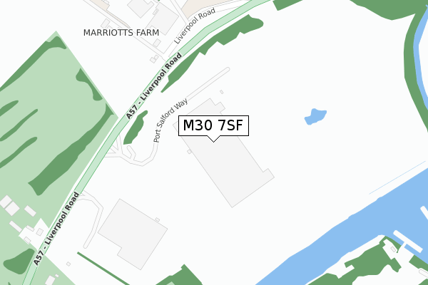
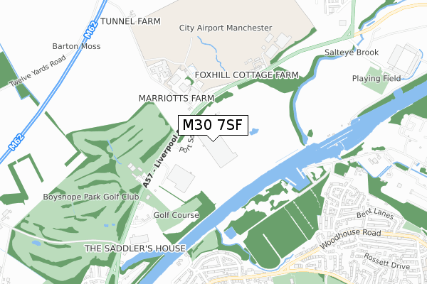
M30 7SF lies on Port Salford Way in Eccles, Manchester. M30 7SF is located in the Higher Irlam & Peel Green electoral ward, within the metropolitan district of Salford and the English Parliamentary constituency of Worsley and Eccles South. The Sub Integrated Care Board (ICB) Location is NHS Greater Manchester ICB - 01G and the police force is Greater Manchester. This postcode has been in use since September 2017.


GetTheData
Source: OS Open Zoomstack (Ordnance Survey)
Licence: Open Government Licence (requires attribution)
Attribution: Contains OS data © Crown copyright and database right 2024
Source: Open Postcode Geo
Licence: Open Government Licence (requires attribution)
Attribution: Contains OS data © Crown copyright and database right 2024; Contains Royal Mail data © Royal Mail copyright and database right 2024; Source: Office for National Statistics licensed under the Open Government Licence v.3.0
| Easting | 374077 |
| Northing | 396537 |
| Latitude | 53.464947 |
| Longitude | -2.391937 |
GetTheData
Source: Open Postcode Geo
Licence: Open Government Licence
| Street | Port Salford Way |
| Locality | Eccles |
| Town/City | Manchester |
| Country | England |
| Postcode District | M30 |
➜ See where M30 is on a map | |
GetTheData
Source: Land Registry Price Paid Data
Licence: Open Government Licence
| Ward | Higher Irlam & Peel Green |
| Constituency | Worsley And Eccles South |
GetTheData
Source: ONS Postcode Database
Licence: Open Government Licence
| Liverpool Rd/Barton Moss Rd (Liverpool Rd) | Barton Moss | 188m |
| Liverpool Rd/Barton Moss Rd (Liverpool Rd) | Barton Moss | 238m |
| Liverpool Rd/Boysnope Farm (Liverpool Rd) | Irlam | 540m |
| Liverpool Rd/Boysnope Farm (Liverpool Rd) | Irlam | 580m |
| Liverpool Rd/Barton Aerodrome (Liverpool Rd) | Barton Aerodrome | 587m |
| Flixton Station | 2.4km |
| Chassen Road Station | 2.6km |
| Urmston Station | 3.1km |
GetTheData
Source: NaPTAN
Licence: Open Government Licence
GetTheData
Source: ONS Postcode Database
Licence: Open Government Licence


➜ Get more ratings from the Food Standards Agency
GetTheData
Source: Food Standards Agency
Licence: FSA terms & conditions
| Last Collection | |||
|---|---|---|---|
| Location | Mon-Fri | Sat | Distance |
| Eddisbury Avenue | 17:30 | 11:30 | 832m |
| Bent Lane | 17:30 | 11:30 | 869m |
| 190 Daveyhulme Road / Lowood Ave | 17:30 | 11:30 | 1,233m |
GetTheData
Source: Dracos
Licence: Creative Commons Attribution-ShareAlike
The below table lists the International Territorial Level (ITL) codes (formerly Nomenclature of Territorial Units for Statistics (NUTS) codes) and Local Administrative Units (LAU) codes for M30 7SF:
| ITL 1 Code | Name |
|---|---|
| TLD | North West (England) |
| ITL 2 Code | Name |
| TLD3 | Greater Manchester |
| ITL 3 Code | Name |
| TLD34 | Greater Manchester South West |
| LAU 1 Code | Name |
| E08000006 | Salford |
GetTheData
Source: ONS Postcode Directory
Licence: Open Government Licence
The below table lists the Census Output Area (OA), Lower Layer Super Output Area (LSOA), and Middle Layer Super Output Area (MSOA) for M30 7SF:
| Code | Name | |
|---|---|---|
| OA | E00028572 | |
| LSOA | E01005640 | Salford 029B |
| MSOA | E02001185 | Salford 029 |
GetTheData
Source: ONS Postcode Directory
Licence: Open Government Licence
| M30 7RJ | Liverpool Road | 239m |
| M30 7RF | Liverpool Road | 632m |
| M41 8GL | Daresbury Avenue | 650m |
| M41 8GP | Daresbury Avenue | 686m |
| M41 8GJ | Daresbury Avenue | 697m |
| M41 8QJ | Eddisbury Avenue | 726m |
| M41 8GE | Eddisbury Avenue | 757m |
| M41 8PH | Ripley Crescent | 760m |
| M41 8PJ | Shipley View | 763m |
| M41 8QN | Woodsend Road | 791m |
GetTheData
Source: Open Postcode Geo; Land Registry Price Paid Data
Licence: Open Government Licence