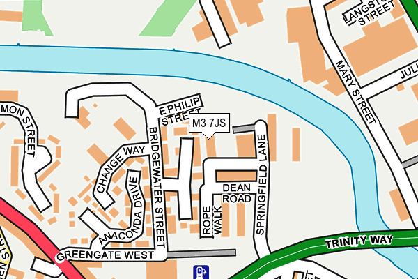
M3 7JS lies on Springfield Lane in Salford. M3 7JS is located in the Blackfriars & Trinity electoral ward, within the metropolitan district of Salford and the English Parliamentary constituency of Salford and Eccles. The Sub Integrated Care Board (ICB) Location is NHS Greater Manchester ICB - 01G and the police force is Greater Manchester. This postcode has been in use since July 2010.


GetTheData
Source: OS OpenMap – Local (Ordnance Survey)
Source: OS VectorMap District (Ordnance Survey)
Licence: Open Government Licence (requires attribution)
| Easting | 383356 |
| Northing | 399229 |
| Latitude | 53.489505 |
| Longitude | -2.252317 |
GetTheData
Source: Open Postcode Geo
Licence: Open Government Licence
| Street | Springfield Lane |
| Town/City | Salford |
| Country | England |
| Postcode District | M3 |
➜ See where M3 is on a map ➜ Where is Salford? | |
GetTheData
Source: Land Registry Price Paid Data
Licence: Open Government Licence
Elevation or altitude of M3 7JS as distance above sea level:
| Metres | Feet | |
|---|---|---|
| Elevation | 30m | 98ft |
Elevation is measured from the approximate centre of the postcode, to the nearest point on an OS contour line from OS Terrain 50, which has contour spacing of ten vertical metres.
➜ How high above sea level am I? Find the elevation of your current position using your device's GPS.
GetTheData
Source: Open Postcode Elevation
Licence: Open Government Licence
| Ward | Blackfriars & Trinity |
| Constituency | Salford And Eccles |
GetTheData
Source: ONS Postcode Database
Licence: Open Government Licence
| Blackfriars Rd/Greengate West (Blackfriars Rd) | Salford | 273m |
| Blackfriars Rd/Greengate West (Blackfriars Rd) | Salford | 289m |
| Great Ducie St/Strangeways (Great Ducie St) | Strangeways | 355m |
| Great Ducie St/Strangeways (Great Ducie St) | Strangeways | 357m |
| Blackfriars Rd/King St (Blackfriars Rd) | Salford | 371m |
| Victoria (Manchester Metrolink) (Off Corporation Street) | Manchester City Centre | 723m |
| Exchange Square (Manchester Metrolink) (Corporation St) | Manchester City Centre | 852m |
| Shudehill (Manchester Metrolink) (Shudehill) | Manchester City Centre | 1,037m |
| Market Street (Manchester Metrolink) (Market Street) | Manchester City Centre | 1,215m |
| St Peters Square (Manchester Metrolink) (Peter Street) | Manchester City Centre | 1,398m |
| Manchester Victoria Station | 0.7km |
| Salford Central Station | 0.7km |
| Salford Crescent Station | 1.6km |
GetTheData
Source: NaPTAN
Licence: Open Government Licence
GetTheData
Source: ONS Postcode Database
Licence: Open Government Licence


➜ Get more ratings from the Food Standards Agency
GetTheData
Source: Food Standards Agency
Licence: FSA terms & conditions
| Last Collection | |||
|---|---|---|---|
| Location | Mon-Fri | Sat | Distance |
| Newbank Towers, Junc Of | 19:00 | 12:00 | 269m |
| Strangeways | 19:00 | 12:00 | 339m |
| Gravel Lane | 19:00 | 12:00 | 344m |
GetTheData
Source: Dracos
Licence: Creative Commons Attribution-ShareAlike
| Risk of M3 7JS flooding from rivers and sea | Low |
| ➜ M3 7JS flood map | |
GetTheData
Source: Open Flood Risk by Postcode
Licence: Open Government Licence
The below table lists the International Territorial Level (ITL) codes (formerly Nomenclature of Territorial Units for Statistics (NUTS) codes) and Local Administrative Units (LAU) codes for M3 7JS:
| ITL 1 Code | Name |
|---|---|
| TLD | North West (England) |
| ITL 2 Code | Name |
| TLD3 | Greater Manchester |
| ITL 3 Code | Name |
| TLD34 | Greater Manchester South West |
| LAU 1 Code | Name |
| E08000006 | Salford |
GetTheData
Source: ONS Postcode Directory
Licence: Open Government Licence
The below table lists the Census Output Area (OA), Lower Layer Super Output Area (LSOA), and Middle Layer Super Output Area (MSOA) for M3 7JS:
| Code | Name | |
|---|---|---|
| OA | E00172943 | |
| LSOA | E01032911 | Salford 022J |
| MSOA | E02001178 | Salford 022 |
GetTheData
Source: ONS Postcode Directory
Licence: Open Government Licence
| M3 7AF | Georgette Drive | 45m |
| M3 7AR | Twillbrook Drive | 53m |
| M3 7EH | Dean Road | 60m |
| M3 7AS | Bridgewater Street | 78m |
| M3 7AL | Poplin Drive | 101m |
| M3 7GE | Evans Street | 112m |
| M3 7JZ | Bridgewater Street | 120m |
| M3 7AD | Anaconda Drive | 151m |
| M3 7JY | Bridgewater Street | 164m |
| M3 7LB | Bridgewater Street | 183m |
GetTheData
Source: Open Postcode Geo; Land Registry Price Paid Data
Licence: Open Government Licence