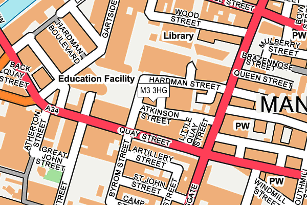
M3 3HG is located in the Deansgate electoral ward, within the metropolitan district of Manchester and the English Parliamentary constituency of Manchester Central. The Sub Integrated Care Board (ICB) Location is NHS Greater Manchester ICB - 14L and the police force is Greater Manchester. This postcode has been in use since August 2007.


GetTheData
Source: OS OpenMap – Local (Ordnance Survey)
Source: OS VectorMap District (Ordnance Survey)
Licence: Open Government Licence (requires attribution)
| Easting | 383430 |
| Northing | 398082 |
| Latitude | 53.479214 |
| Longitude | -2.251139 |
GetTheData
Source: Open Postcode Geo
Licence: Open Government Licence
| Country | England |
| Postcode District | M3 |
➜ See where M3 is on a map ➜ Where is Manchester? | |
GetTheData
Source: Land Registry Price Paid Data
Licence: Open Government Licence
Elevation or altitude of M3 3HG as distance above sea level:
| Metres | Feet | |
|---|---|---|
| Elevation | 30m | 98ft |
Elevation is measured from the approximate centre of the postcode, to the nearest point on an OS contour line from OS Terrain 50, which has contour spacing of ten vertical metres.
➜ How high above sea level am I? Find the elevation of your current position using your device's GPS.
GetTheData
Source: Open Postcode Elevation
Licence: Open Government Licence
| Ward | Deansgate |
| Constituency | Manchester Central |
GetTheData
Source: ONS Postcode Database
Licence: Open Government Licence
| Byrom St/Hardman St (Byrom St) | Spinningfields | 42m |
| Quay St/Opera House (Quay St) | Spinningfields | 63m |
| Quay St/Deansgate (Quay St) | Spinningfields | 80m |
| Gartside St/Spinningfields (Gartside St) | Spinningfields | 138m |
| Quay St/Lower Byrom St (Quay St) | Spinningfields | 165m |
| Deansgate-castlefield (Manchester Metrolink) (Whitworth Street West) | Manchester City Centre | 495m |
| St Peters Square (Manchester Metrolink) (Peter Street) | Manchester City Centre | 544m |
| Exchange Square (Manchester Metrolink) (Corporation St) | Manchester City Centre | 810m |
| Market Street (Manchester Metrolink) (Market Street) | Manchester City Centre | 853m |
| Piccadilly Gardens (Manchester Metrolink) (Portland Street) | Piccadilly Gardens | 973m |
| Salford Central Station | 0.5km |
| Deansgate Station | 0.6km |
| Manchester Oxford Road Station | 0.8km |
GetTheData
Source: NaPTAN
Licence: Open Government Licence
GetTheData
Source: ONS Postcode Database
Licence: Open Government Licence


➜ Get more ratings from the Food Standards Agency
GetTheData
Source: Food Standards Agency
Licence: FSA terms & conditions
| Last Collection | |||
|---|---|---|---|
| Location | Mon-Fri | Sat | Distance |
| Hardman Street | 19:00 | 12:00 | 143m |
| Opp 28 St John Street | 19:00 | 12:00 | 159m |
| Peter Street | 19:00 | 12:00 | 160m |
GetTheData
Source: Dracos
Licence: Creative Commons Attribution-ShareAlike
The below table lists the International Territorial Level (ITL) codes (formerly Nomenclature of Territorial Units for Statistics (NUTS) codes) and Local Administrative Units (LAU) codes for M3 3HG:
| ITL 1 Code | Name |
|---|---|
| TLD | North West (England) |
| ITL 2 Code | Name |
| TLD3 | Greater Manchester |
| ITL 3 Code | Name |
| TLD33 | Manchester |
| LAU 1 Code | Name |
| E08000003 | Manchester |
GetTheData
Source: ONS Postcode Directory
Licence: Open Government Licence
The below table lists the Census Output Area (OA), Lower Layer Super Output Area (LSOA), and Middle Layer Super Output Area (MSOA) for M3 3HG:
| Code | Name | |
|---|---|---|
| OA | E00175998 | |
| LSOA | E01033681 | Manchester 060B |
| MSOA | E02006917 | Manchester 060 |
GetTheData
Source: ONS Postcode Directory
Licence: Open Government Licence
| M3 3HF | Hardman Street | 78m |
| M3 4PF | Byrom Street | 122m |
| M3 3EB | Hardman Square | 125m |
| M3 3EL | Gartside Street | 140m |
| M3 3EJ | Quay Street | 154m |
| M3 4BQ | Deansgate | 154m |
| M2 5GU | Bootle Street | 166m |
| M3 4DT | St John Street | 171m |
| M3 4AN | Lower Byrom Street | 174m |
| M3 4DG | St John Street | 175m |
GetTheData
Source: Open Postcode Geo; Land Registry Price Paid Data
Licence: Open Government Licence