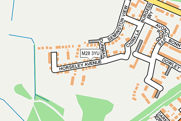
M28 3YU is located in the Walkden South electoral ward, within the metropolitan district of Salford and the English Parliamentary constituency of Worsley and Eccles South. The Sub Integrated Care Board (ICB) Location is NHS Greater Manchester ICB - 01G and the police force is Greater Manchester. This postcode has been in use since July 2018.


GetTheData
Source: OS OpenMap – Local (Ordnance Survey)
Source: OS VectorMap District (Ordnance Survey)
Licence: Open Government Licence (requires attribution)
| Easting | 374036 |
| Northing | 402675 |
| Latitude | 53.520115 |
| Longitude | -2.393064 |
GetTheData
Source: Open Postcode Geo
Licence: Open Government Licence
| Country | England |
| Postcode District | M28 |
➜ See where M28 is on a map ➜ Where is Walkden? | |
GetTheData
Source: Land Registry Price Paid Data
Licence: Open Government Licence
| Ward | Walkden South |
| Constituency | Worsley And Eccles South |
GetTheData
Source: ONS Postcode Database
Licence: Open Government Licence
| Holyoake Road | Walkden | 46m |
| Holly Avenue/Holyoake Road (Holly Avenue) | Walkden | 127m |
| Walkden Rd/Walkden Stn (Walkden Rd) | Walkden | 229m |
| Birch Rd/Lime Gr (Birch Rd) | Parr Fold | 237m |
| Chilham Road | Walkden | 242m |
| Walkden Station | 0.2km |
| Moorside Station | 2.8km |
| Kearsley Station | 2.9km |
GetTheData
Source: NaPTAN
Licence: Open Government Licence
| Percentage of properties with Next Generation Access | 100.0% |
| Percentage of properties with Superfast Broadband | 100.0% |
| Percentage of properties with Ultrafast Broadband | 100.0% |
| Percentage of properties with Full Fibre Broadband | 100.0% |
Superfast Broadband is between 30Mbps and 300Mbps
Ultrafast Broadband is > 300Mbps
| Percentage of properties unable to receive 2Mbps | 0.0% |
| Percentage of properties unable to receive 5Mbps | 0.0% |
| Percentage of properties unable to receive 10Mbps | 0.0% |
| Percentage of properties unable to receive 30Mbps | 0.0% |
GetTheData
Source: Ofcom
Licence: Ofcom Terms of Use (requires attribution)
GetTheData
Source: ONS Postcode Database
Licence: Open Government Licence


➜ Get more ratings from the Food Standards Agency
GetTheData
Source: Food Standards Agency
Licence: FSA terms & conditions
| Last Collection | |||
|---|---|---|---|
| Location | Mon-Fri | Sat | Distance |
| Walkden Road | 17:30 | 12:00 | 287m |
| Walkden Rd/Edgefold Road | 17:30 | 12:00 | 468m |
| 6 City Road Off Bridgewater Road | 17:30 | 12:00 | 509m |
GetTheData
Source: Dracos
Licence: Creative Commons Attribution-ShareAlike
The below table lists the International Territorial Level (ITL) codes (formerly Nomenclature of Territorial Units for Statistics (NUTS) codes) and Local Administrative Units (LAU) codes for M28 3YU:
| ITL 1 Code | Name |
|---|---|
| TLD | North West (England) |
| ITL 2 Code | Name |
| TLD3 | Greater Manchester |
| ITL 3 Code | Name |
| TLD34 | Greater Manchester South West |
| LAU 1 Code | Name |
| E08000006 | Salford |
GetTheData
Source: ONS Postcode Directory
Licence: Open Government Licence
The below table lists the Census Output Area (OA), Lower Layer Super Output Area (LSOA), and Middle Layer Super Output Area (MSOA) for M28 3YU:
| Code | Name | |
|---|---|---|
| OA | E00028954 | |
| LSOA | E01005712 | Salford 007B |
| MSOA | E02001163 | Salford 007 |
GetTheData
Source: ONS Postcode Directory
Licence: Open Government Licence
| M28 3DL | Holyoake Road | 32m |
| M28 7EE | Chestnut Avenue | 101m |
| M28 3DF | Old Oake Close | 101m |
| M28 3DP | Chilham Road | 140m |
| M28 3DN | Blantyre Avenue | 144m |
| M28 3DJ | Collyhurst Avenue | 161m |
| M28 3XN | Sandwich Street | 188m |
| M28 3DW | Holly Avenue | 188m |
| M28 3DG | Atkin Street | 198m |
| M28 3DY | Walkden Road | 213m |
GetTheData
Source: Open Postcode Geo; Land Registry Price Paid Data
Licence: Open Government Licence