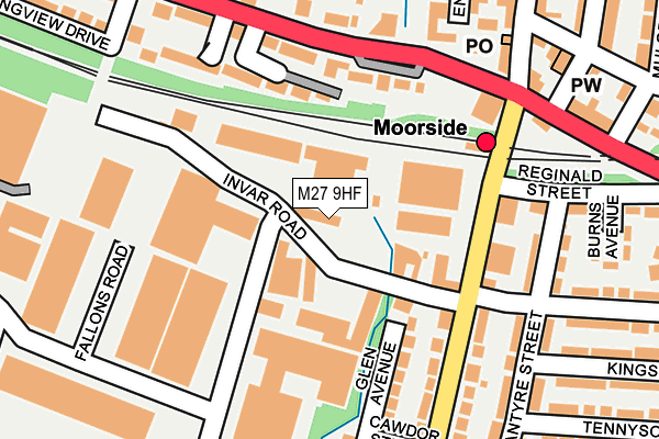
M27 9HF lies on Invar Road in Swinton, Manchester. M27 9HF is located in the Swinton & Wardley electoral ward, within the metropolitan district of Salford and the English Parliamentary constituency of Salford and Eccles. The Sub Integrated Care Board (ICB) Location is NHS Greater Manchester ICB - 01G and the police force is Greater Manchester. This postcode has been in use since May 1994.


GetTheData
Source: OS OpenMap – Local (Ordnance Survey)
Source: OS VectorMap District (Ordnance Survey)
Licence: Open Government Licence (requires attribution)
| Easting | 376624 |
| Northing | 402172 |
| Latitude | 53.515716 |
| Longitude | -2.353995 |
GetTheData
Source: Open Postcode Geo
Licence: Open Government Licence
| Street | Invar Road |
| Locality | Swinton |
| Town/City | Manchester |
| Country | England |
| Postcode District | M27 |
➜ See where M27 is on a map ➜ Where is Swinton? | |
GetTheData
Source: Land Registry Price Paid Data
Licence: Open Government Licence
Elevation or altitude of M27 9HF as distance above sea level:
| Metres | Feet | |
|---|---|---|
| Elevation | 80m | 262ft |
Elevation is measured from the approximate centre of the postcode, to the nearest point on an OS contour line from OS Terrain 50, which has contour spacing of ten vertical metres.
➜ How high above sea level am I? Find the elevation of your current position using your device's GPS.
GetTheData
Source: Open Postcode Elevation
Licence: Open Government Licence
| Ward | Swinton & Wardley |
| Constituency | Salford And Eccles |
GetTheData
Source: ONS Postcode Database
Licence: Open Government Licence
STUDIO HOUSE, 40, INVAR ROAD, SWINTON, MANCHESTER, M27 9HF 1999 14 JUN £755,000 |
GetTheData
Source: HM Land Registry Price Paid Data
Licence: Contains HM Land Registry data © Crown copyright and database right 2025. This data is licensed under the Open Government Licence v3.0.
| Moorside Rd/Moorside Stn (Moorside Rd) | Wardley | 169m |
| Chorley Rd/Moorside Rd (Chorley Rd) | Wardley | 180m |
| Moss Lane (Nth Bnd) (Moss Lane) | Wardley | 218m |
| Chorley Rd/Moorside Rd (Chorley Rd) | Wardley | 221m |
| Moorside Rd/Wenlock St (Moorside Rd) | Wardley | 268m |
| Moorside Station | 0.2km |
| Swinton (Manchester) Station | 1.1km |
| Clifton (Manchester) Station | 2.7km |
GetTheData
Source: NaPTAN
Licence: Open Government Licence
GetTheData
Source: ONS Postcode Database
Licence: Open Government Licence


➜ Get more ratings from the Food Standards Agency
GetTheData
Source: Food Standards Agency
Licence: FSA terms & conditions
| Last Collection | |||
|---|---|---|---|
| Location | Mon-Fri | Sat | Distance |
| Heywood Street | 17:30 | 12:00 | 840m |
| Broad Oak Road | 17:30 | 12:00 | 1,319m |
| Roe Green P.o. | 17:30 | 12:00 | 1,547m |
GetTheData
Source: Dracos
Licence: Creative Commons Attribution-ShareAlike
The below table lists the International Territorial Level (ITL) codes (formerly Nomenclature of Territorial Units for Statistics (NUTS) codes) and Local Administrative Units (LAU) codes for M27 9HF:
| ITL 1 Code | Name |
|---|---|
| TLD | North West (England) |
| ITL 2 Code | Name |
| TLD3 | Greater Manchester |
| ITL 3 Code | Name |
| TLD34 | Greater Manchester South West |
| LAU 1 Code | Name |
| E08000006 | Salford |
GetTheData
Source: ONS Postcode Directory
Licence: Open Government Licence
The below table lists the Census Output Area (OA), Lower Layer Super Output Area (LSOA), and Middle Layer Super Output Area (MSOA) for M27 9HF:
| Code | Name | |
|---|---|---|
| OA | E00028802 | |
| LSOA | E01005693 | Salford 009D |
| MSOA | E02001165 | Salford 009 |
GetTheData
Source: ONS Postcode Directory
Licence: Open Government Licence
| M27 9HH | Moorside Road | 88m |
| M27 9QZ | Banbury Mews | 131m |
| M27 9RJ | Chorley Road | 141m |
| M27 9PN | Moorside Road | 173m |
| M27 9PW | Moorside Road | 177m |
| M27 9PL | Glen Avenue | 184m |
| M27 9PQ | Blantyre Street | 187m |
| M27 9GE | Brightsmith Way | 197m |
| M27 9QH | Manchester Road | 199m |
| M27 9RA | Manchester Road | 213m |
GetTheData
Source: Open Postcode Geo; Land Registry Price Paid Data
Licence: Open Government Licence