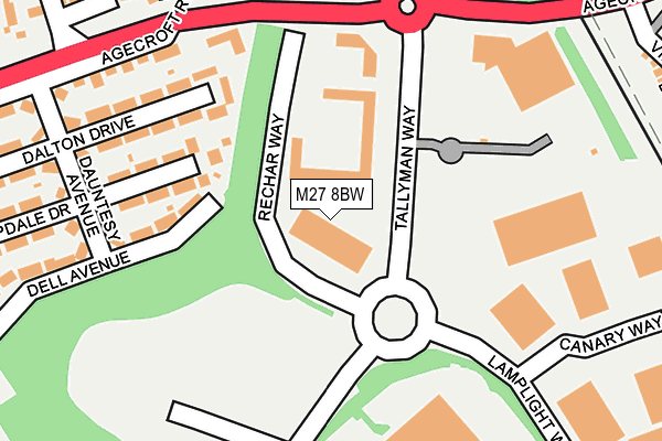
M27 8BW is located in the Pendlebury & Clifton electoral ward, within the metropolitan district of Salford and the English Parliamentary constituency of Salford and Eccles. The Sub Integrated Care Board (ICB) Location is NHS Greater Manchester ICB - 01G and the police force is Greater Manchester. This postcode has been in use since April 2017.


GetTheData
Source: OS OpenMap – Local (Ordnance Survey)
Source: OS VectorMap District (Ordnance Survey)
Licence: Open Government Licence (requires attribution)
| Easting | 380001 |
| Northing | 401384 |
| Latitude | 53.508774 |
| Longitude | -2.303018 |
GetTheData
Source: Open Postcode Geo
Licence: Open Government Licence
| Country | England |
| Postcode District | M27 |
➜ See where M27 is on a map ➜ Where is Pendlebury? | |
GetTheData
Source: Land Registry Price Paid Data
Licence: Open Government Licence
| Ward | Pendlebury & Clifton |
| Constituency | Salford And Eccles |
GetTheData
Source: ONS Postcode Database
Licence: Open Government Licence
| Tallyman Way/Agecroft Park (Tallyman Way) | Agecroft | 77m |
| Agecroft Rd/Enterprise Park (Agecroft Rd) | Agecroft | 234m |
| Agecroft Rd/Dauntesey Ave (Agecroft Rd) | Agecroft | 267m |
| Agecroft Rd/Dauntesey Ave (Agecroft Rd) | Agecroft | 326m |
| Agecroft Rd/Langley Rd (Agecroft Rd) | Agecroft | 452m |
| Clifton (Manchester) Station | 1.7km |
| Swinton (Manchester) Station | 2.4km |
| Salford Crescent Station | 3.1km |
GetTheData
Source: NaPTAN
Licence: Open Government Licence
GetTheData
Source: ONS Postcode Database
Licence: Open Government Licence


➜ Get more ratings from the Food Standards Agency
GetTheData
Source: Food Standards Agency
Licence: FSA terms & conditions
| Last Collection | |||
|---|---|---|---|
| Location | Mon-Fri | Sat | Distance |
| Agecroft Road | 17:30 | 12:00 | 280m |
| Cromwell Bridge P.o. | 17:30 | 12:00 | 1,075m |
| Temple Drive | 17:30 | 12:00 | 1,558m |
GetTheData
Source: Dracos
Licence: Creative Commons Attribution-ShareAlike
The below table lists the International Territorial Level (ITL) codes (formerly Nomenclature of Territorial Units for Statistics (NUTS) codes) and Local Administrative Units (LAU) codes for M27 8BW:
| ITL 1 Code | Name |
|---|---|
| TLD | North West (England) |
| ITL 2 Code | Name |
| TLD3 | Greater Manchester |
| ITL 3 Code | Name |
| TLD34 | Greater Manchester South West |
| LAU 1 Code | Name |
| E08000006 | Salford |
GetTheData
Source: ONS Postcode Directory
Licence: Open Government Licence
The below table lists the Census Output Area (OA), Lower Layer Super Output Area (LSOA), and Middle Layer Super Output Area (MSOA) for M27 8BW:
| Code | Name | |
|---|---|---|
| OA | E00028737 | |
| LSOA | E01005673 | Salford 008A |
| MSOA | E02001164 | Salford 008 |
GetTheData
Source: ONS Postcode Directory
Licence: Open Government Licence
| M27 8TU | Dell Avenue | 148m |
| M27 8TZ | Deepdale Drive | 173m |
| M27 8UD | Dalton Drive | 184m |
| M27 8UF | Agecroft Road | 196m |
| M27 8TY | Dauntesy Avenue | 233m |
| M27 8BA | Giants Seat Grove | 234m |
| M27 8BD | Giants Seat Grove | 235m |
| M27 8UH | Agecroft Road | 240m |
| M27 8UA | Dauntesy Avenue | 252m |
| M27 8BE | Giants Seat Grove | 252m |
GetTheData
Source: Open Postcode Geo; Land Registry Price Paid Data
Licence: Open Government Licence