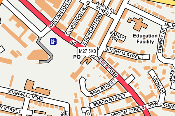
M27 5XB lies on Chorley Road in Swinton, Manchester. M27 5XB is located in the Swinton & Wardley electoral ward, within the metropolitan district of Salford and the English Parliamentary constituency of Salford and Eccles. The Sub Integrated Care Board (ICB) Location is NHS Greater Manchester ICB - 01G and the police force is Greater Manchester. This postcode has been in use since May 1994.


GetTheData
Source: OS OpenMap – Local (Ordnance Survey)
Source: OS VectorMap District (Ordnance Survey)
Licence: Open Government Licence (requires attribution)
| Easting | 377804 |
| Northing | 401534 |
| Latitude | 53.510017 |
| Longitude | -2.336156 |
GetTheData
Source: Open Postcode Geo
Licence: Open Government Licence
| Street | Chorley Road |
| Locality | Swinton |
| Town/City | Manchester |
| Country | England |
| Postcode District | M27 |
➜ See where M27 is on a map ➜ Where is Swinton? | |
GetTheData
Source: Land Registry Price Paid Data
Licence: Open Government Licence
Elevation or altitude of M27 5XB as distance above sea level:
| Metres | Feet | |
|---|---|---|
| Elevation | 70m | 230ft |
Elevation is measured from the approximate centre of the postcode, to the nearest point on an OS contour line from OS Terrain 50, which has contour spacing of ten vertical metres.
➜ How high above sea level am I? Find the elevation of your current position using your device's GPS.
GetTheData
Source: Open Postcode Elevation
Licence: Open Government Licence
| Ward | Swinton & Wardley |
| Constituency | Salford And Eccles |
GetTheData
Source: ONS Postcode Database
Licence: Open Government Licence
| Chorley Rd/Swinton Po (Chorley Rd) | Swinton | 22m |
| Chorley Rd/Swinton Dental Ctr (Chorley Rd) | Swinton | 104m |
| Chorley Rd/Swinton Civic Ctr (Chorley Rd) | Swinton | 262m |
| Chorley Rd/Swinton Civic Ctr (Chorley Rd) | Swinton | 290m |
| Worsley Rd/Chorley Rd (Worsley Rd) | Light Bourne Green | 299m |
| Swinton (Manchester) Station | 0.5km |
| Moorside Station | 1.2km |
| Clifton (Manchester) Station | 2km |
GetTheData
Source: NaPTAN
Licence: Open Government Licence
GetTheData
Source: ONS Postcode Database
Licence: Open Government Licence


➜ Get more ratings from the Food Standards Agency
GetTheData
Source: Food Standards Agency
Licence: FSA terms & conditions
| Last Collection | |||
|---|---|---|---|
| Location | Mon-Fri | Sat | Distance |
| Market Place | 17:30 | 12:00 | 303m |
| Swinton P.o. | 18:15 | 12:00 | 562m |
| Heywood Street | 17:30 | 12:00 | 564m |
GetTheData
Source: Dracos
Licence: Creative Commons Attribution-ShareAlike
The below table lists the International Territorial Level (ITL) codes (formerly Nomenclature of Territorial Units for Statistics (NUTS) codes) and Local Administrative Units (LAU) codes for M27 5XB:
| ITL 1 Code | Name |
|---|---|
| TLD | North West (England) |
| ITL 2 Code | Name |
| TLD3 | Greater Manchester |
| ITL 3 Code | Name |
| TLD34 | Greater Manchester South West |
| LAU 1 Code | Name |
| E08000006 | Salford |
GetTheData
Source: ONS Postcode Directory
Licence: Open Government Licence
The below table lists the Census Output Area (OA), Lower Layer Super Output Area (LSOA), and Middle Layer Super Output Area (MSOA) for M27 5XB:
| Code | Name | |
|---|---|---|
| OA | E00028830 | |
| LSOA | E01005700 | Salford 012F |
| MSOA | E02001168 | Salford 012 |
GetTheData
Source: ONS Postcode Directory
Licence: Open Government Licence
| M27 5AD | Chorley Road | 65m |
| M27 4AA | Chorley Road | 88m |
| M27 5AE | Bain Street | 103m |
| M27 4BW | Stafford Road | 114m |
| M27 4AH | Sandy Grove | 128m |
| M27 4AR | Pendlebury Road | 131m |
| M27 4AD | Meads Court | 134m |
| M27 4BP | Clarendon Road | 142m |
| M27 4AG | Pendlebury Road | 151m |
| M27 5AH | Beech Street | 152m |
GetTheData
Source: Open Postcode Geo; Land Registry Price Paid Data
Licence: Open Government Licence