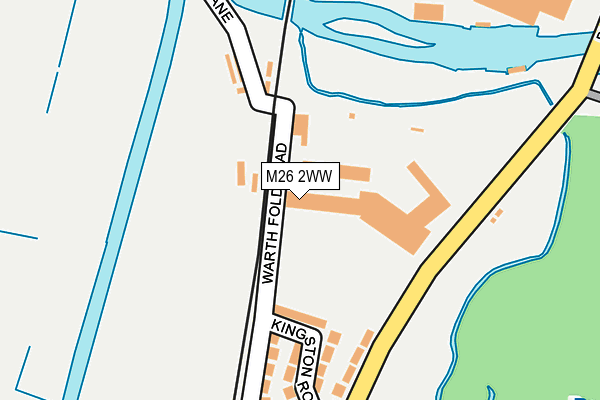
M26 2WW is located in the Radcliffe East electoral ward, within the metropolitan district of Bury and the English Parliamentary constituency of Bury South. The Sub Integrated Care Board (ICB) Location is NHS Greater Manchester ICB - 00V and the police force is Greater Manchester. This postcode has been in use since January 1995.


GetTheData
Source: OS OpenMap – Local (Ordnance Survey)
Source: OS VectorMap District (Ordnance Survey)
Licence: Open Government Licence (requires attribution)
| Easting | 379406 |
| Northing | 408882 |
| Latitude | 53.576127 |
| Longitude | -2.312487 |
GetTheData
Source: Open Postcode Geo
Licence: Open Government Licence
| Country | England |
| Postcode District | M26 |
➜ See where M26 is on a map ➜ Where is Radcliffe? | |
GetTheData
Source: Land Registry Price Paid Data
Licence: Open Government Licence
Elevation or altitude of M26 2WW as distance above sea level:
| Metres | Feet | |
|---|---|---|
| Elevation | 70m | 230ft |
Elevation is measured from the approximate centre of the postcode, to the nearest point on an OS contour line from OS Terrain 50, which has contour spacing of ten vertical metres.
➜ How high above sea level am I? Find the elevation of your current position using your device's GPS.
GetTheData
Source: Open Postcode Elevation
Licence: Open Government Licence
| Ward | Radcliffe East |
| Constituency | Bury South |
GetTheData
Source: ONS Postcode Database
Licence: Open Government Licence
| Bury Rd/Kingston Rd (Bury Rd) | Radcliffe | 202m |
| Bury Rd/Kingston Rd (Bury Rd) | Radcliffe | 265m |
| Radcliffe Rd/Warth Bridge (Radcliffe Rd) | Warth Fold | 307m |
| Radcliffe Rd/Warth Bridge (Radcliffe Rd) | Warth Fold | 364m |
| Bury Rd/Eton Hill Rd (Bury Rd) | Radcliffe | 424m |
| Kearsley Station | 5.5km |
GetTheData
Source: NaPTAN
Licence: Open Government Licence
GetTheData
Source: ONS Postcode Database
Licence: Open Government Licence


➜ Get more ratings from the Food Standards Agency
GetTheData
Source: Food Standards Agency
Licence: FSA terms & conditions
| Last Collection | |||
|---|---|---|---|
| Location | Mon-Fri | Sat | Distance |
| Rectory Lane | 17:30 | 12:00 | 1,515m |
| 126 Parkhills Road | 17:20 | 10:50 | 1,695m |
| Black Lane P.o. | 17:30 | 12:00 | 1,750m |
GetTheData
Source: Dracos
Licence: Creative Commons Attribution-ShareAlike
The below table lists the International Territorial Level (ITL) codes (formerly Nomenclature of Territorial Units for Statistics (NUTS) codes) and Local Administrative Units (LAU) codes for M26 2WW:
| ITL 1 Code | Name |
|---|---|
| TLD | North West (England) |
| ITL 2 Code | Name |
| TLD3 | Greater Manchester |
| ITL 3 Code | Name |
| TLD37 | Greater Manchester North East |
| LAU 1 Code | Name |
| E08000002 | Bury |
GetTheData
Source: ONS Postcode Directory
Licence: Open Government Licence
The below table lists the Census Output Area (OA), Lower Layer Super Output Area (LSOA), and Middle Layer Super Output Area (MSOA) for M26 2WW:
| Code | Name | |
|---|---|---|
| OA | E00025280 | |
| LSOA | E01004991 | Bury 015A |
| MSOA | E02001033 | Bury 015 |
GetTheData
Source: ONS Postcode Directory
Licence: Open Government Licence
| M26 2XN | Kingston Road | 155m |
| M26 2XW | Bury Road | 195m |
| M26 2XL | Warth Fold Road | 229m |
| M26 2XJ | Farcroft Avenue | 340m |
| BL9 9TB | Warth Road | 357m |
| M26 2ZS | Eton Hill Road | 428m |
| M26 2XF | Bury Road | 445m |
| M26 2YL | Oakwood Grove | 465m |
| BL9 9NA | Bealey Drive | 480m |
| BL9 9NQ | Mellor Drive | 483m |
GetTheData
Source: Open Postcode Geo; Land Registry Price Paid Data
Licence: Open Government Licence