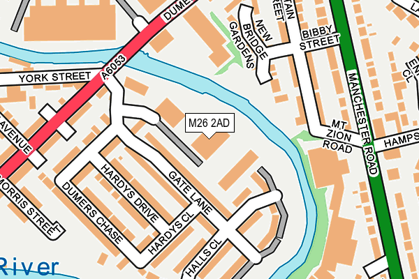
M26 2AD lies on Riverview Close in Radcliffe, Manchester. M26 2AD is located in the Radcliffe East electoral ward, within the metropolitan district of Bury and the English Parliamentary constituency of Bury South. The Sub Integrated Care Board (ICB) Location is NHS Greater Manchester ICB - 00V and the police force is Greater Manchester. This postcode has been in use since June 2014.


GetTheData
Source: OS OpenMap – Local (Ordnance Survey)
Source: OS VectorMap District (Ordnance Survey)
Licence: Open Government Licence (requires attribution)
| Easting | 380372 |
| Northing | 408308 |
| Latitude | 53.571021 |
| Longitude | -2.297860 |
GetTheData
Source: Open Postcode Geo
Licence: Open Government Licence
| Street | Riverview Close |
| Locality | Radcliffe |
| Town/City | Manchester |
| Country | England |
| Postcode District | M26 |
➜ See where M26 is on a map ➜ Where is Radcliffe? | |
GetTheData
Source: Land Registry Price Paid Data
Licence: Open Government Licence
Elevation or altitude of M26 2AD as distance above sea level:
| Metres | Feet | |
|---|---|---|
| Elevation | 70m | 230ft |
Elevation is measured from the approximate centre of the postcode, to the nearest point on an OS contour line from OS Terrain 50, which has contour spacing of ten vertical metres.
➜ How high above sea level am I? Find the elevation of your current position using your device's GPS.
GetTheData
Source: Open Postcode Elevation
Licence: Open Government Licence
| Ward | Radcliffe East |
| Constituency | Bury South |
GetTheData
Source: ONS Postcode Database
Licence: Open Government Licence
| Dumers Ln/Trade Park (Dumers Ln) | Radcliffe | 163m |
| Dumers Ln/The Bridge Inn (Dumers Ln) | Radcliffe | 195m |
| Dumers Ln/Trade Park (Dumers Ln) | Radcliffe | 198m |
| Manchester Rd/Mount Zion Rd (Manchester Rd) | Fletcher Fold | 216m |
| Manchester Rd/Mount Zion Rd (Manchester Rd) | Fletcher Fold | 254m |
GetTheData
Source: NaPTAN
Licence: Open Government Licence
GetTheData
Source: ONS Postcode Database
Licence: Open Government Licence


➜ Get more ratings from the Food Standards Agency
GetTheData
Source: Food Standards Agency
Licence: FSA terms & conditions
| Last Collection | |||
|---|---|---|---|
| Location | Mon-Fri | Sat | Distance |
| Fishpool P O | 18:30 | 11:20 | 1,395m |
| 126 Parkhills Road | 17:20 | 10:50 | 1,621m |
| Rectory Lane | 17:30 | 12:00 | 1,670m |
GetTheData
Source: Dracos
Licence: Creative Commons Attribution-ShareAlike
| Risk of M26 2AD flooding from rivers and sea | Low |
| ➜ M26 2AD flood map | |
GetTheData
Source: Open Flood Risk by Postcode
Licence: Open Government Licence
The below table lists the International Territorial Level (ITL) codes (formerly Nomenclature of Territorial Units for Statistics (NUTS) codes) and Local Administrative Units (LAU) codes for M26 2AD:
| ITL 1 Code | Name |
|---|---|
| TLD | North West (England) |
| ITL 2 Code | Name |
| TLD3 | Greater Manchester |
| ITL 3 Code | Name |
| TLD37 | Greater Manchester North East |
| LAU 1 Code | Name |
| E08000002 | Bury |
GetTheData
Source: ONS Postcode Directory
Licence: Open Government Licence
The below table lists the Census Output Area (OA), Lower Layer Super Output Area (LSOA), and Middle Layer Super Output Area (MSOA) for M26 2AD:
| Code | Name | |
|---|---|---|
| OA | E00025283 | |
| LSOA | E01004993 | Bury 015C |
| MSOA | E02001033 | Bury 015 |
GetTheData
Source: ONS Postcode Directory
Licence: Open Government Licence
| M26 2AF | Gate Lane | 61m |
| M26 2TE | Gate Lane | 94m |
| M26 2TL | Hardys Drive | 122m |
| BL9 9QP | Dumers Lane | 145m |
| BL9 9PJ | New Bridge Gardens | 168m |
| BL9 9PB | Britain Street | 169m |
| BL9 9PD | Britain Street | 172m |
| M26 2TN | Hardys Close | 187m |
| M26 2TH | Dumers Chase | 188m |
| M26 2AG | Halls Close | 191m |
GetTheData
Source: Open Postcode Geo; Land Registry Price Paid Data
Licence: Open Government Licence