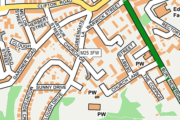
M25 3FW is located in the St. Mary's electoral ward, within the metropolitan district of Bury and the English Parliamentary constituency of Bury South. The Sub Integrated Care Board (ICB) Location is NHS Greater Manchester ICB - 00V and the police force is Greater Manchester. This postcode has been in use since June 1996.


GetTheData
Source: OS OpenMap – Local (Ordnance Survey)
Source: OS VectorMap District (Ordnance Survey)
Licence: Open Government Licence (requires attribution)
| Easting | 381089 |
| Northing | 403832 |
| Latitude | 53.530801 |
| Longitude | -2.286763 |
GetTheData
Source: Open Postcode Geo
Licence: Open Government Licence
| Country | England |
| Postcode District | M25 |
➜ See where M25 is on a map ➜ Where is Prestwich? | |
GetTheData
Source: Land Registry Price Paid Data
Licence: Open Government Licence
Elevation or altitude of M25 3FW as distance above sea level:
| Metres | Feet | |
|---|---|---|
| Elevation | 80m | 262ft |
Elevation is measured from the approximate centre of the postcode, to the nearest point on an OS contour line from OS Terrain 50, which has contour spacing of ten vertical metres.
➜ How high above sea level am I? Find the elevation of your current position using your device's GPS.
GetTheData
Source: Open Postcode Elevation
Licence: Open Government Licence
| Ward | St. Mary's |
| Constituency | Bury South |
GetTheData
Source: ONS Postcode Database
Licence: Open Government Licence
| Bury New Rd/Red Lion (Bury New Rd) | Prestwich | 193m |
| Bury New Rd/Longfield Ctr (Bury New Rd) | Prestwich | 223m |
| Bury New Rd/Clifton Rd (Bury New Rd) | Prestwich | 233m |
| Bury New Rd/Red Lion (Bury New Rd) | Prestwich | 244m |
| Bury New Rd/Longfield Ctr (Bury New Rd) | Prestwich | 275m |
| Prestwich (Manchester Metrolink) (Off Fairfax Road) | Prestwich | 426m |
| Besses O'th'barn (Manchester Metrolink) (Off Bury Old Road) | Besses O Th Barn | 1,253m |
| Heaton Park (Manchester Metrolink) (Off Bury Old Road) | Heaton Park | 1,337m |
| Clifton (Manchester) Station | 2.1km |
| Swinton (Manchester) Station | 3.8km |
| Moorside Station | 4.6km |
GetTheData
Source: NaPTAN
Licence: Open Government Licence
GetTheData
Source: ONS Postcode Database
Licence: Open Government Licence


➜ Get more ratings from the Food Standards Agency
GetTheData
Source: Food Standards Agency
Licence: FSA terms & conditions
| Last Collection | |||
|---|---|---|---|
| Location | Mon-Fri | Sat | Distance |
| Church Lane | 17:30 | 11:45 | 211m |
| Prestwich P.o. | 18:00 | 12:00 | 392m |
| Tesco | 17:30 | 12:00 | 521m |
GetTheData
Source: Dracos
Licence: Creative Commons Attribution-ShareAlike
The below table lists the International Territorial Level (ITL) codes (formerly Nomenclature of Territorial Units for Statistics (NUTS) codes) and Local Administrative Units (LAU) codes for M25 3FW:
| ITL 1 Code | Name |
|---|---|
| TLD | North West (England) |
| ITL 2 Code | Name |
| TLD3 | Greater Manchester |
| ITL 3 Code | Name |
| TLD37 | Greater Manchester North East |
| LAU 1 Code | Name |
| E08000002 | Bury |
GetTheData
Source: ONS Postcode Directory
Licence: Open Government Licence
The below table lists the Census Output Area (OA), Lower Layer Super Output Area (LSOA), and Middle Layer Super Output Area (MSOA) for M25 3FW:
| Code | Name | |
|---|---|---|
| OA | E00025473 | |
| LSOA | E01005036 | Bury 024C |
| MSOA | E02001042 | Bury 024 |
GetTheData
Source: ONS Postcode Directory
Licence: Open Government Licence
| M25 3JW | Church Drive | 33m |
| M25 3JS | Clough Drive | 82m |
| M25 3JR | Greengate Lane | 92m |
| M25 3JN | Carmona Drive | 112m |
| M25 3HW | Greengate Lane | 115m |
| M25 1AJ | Church Lane | 119m |
| M25 1NY | Derby Street | 125m |
| M25 3BN | Sherbourne Court | 127m |
| M25 3HS | Gardner Road | 141m |
| M25 3JF | Mountside Crescent | 150m |
GetTheData
Source: Open Postcode Geo; Land Registry Price Paid Data
Licence: Open Government Licence