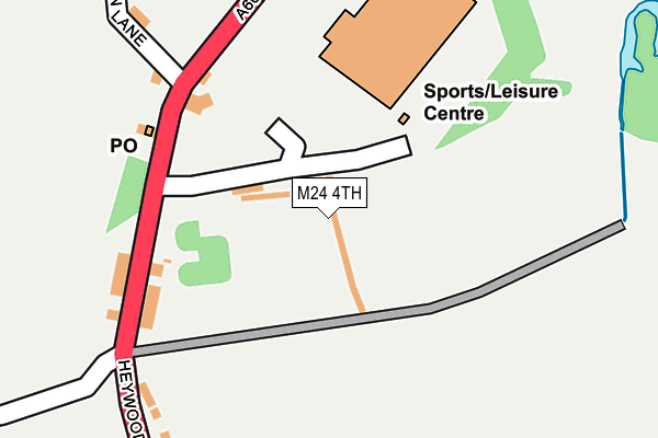
M24 4TH lies on Heywood Old Road in Middleton, Manchester. M24 4TH is located in the South Middleton electoral ward, within the metropolitan district of Rochdale and the English Parliamentary constituency of Heywood and Middleton. The Sub Integrated Care Board (ICB) Location is NHS Greater Manchester ICB - 01D and the police force is Greater Manchester. This postcode has been in use since December 1996.


GetTheData
Source: OS OpenMap – Local (Ordnance Survey)
Source: OS VectorMap District (Ordnance Survey)
Licence: Open Government Licence (requires attribution)
| Easting | 384567 |
| Northing | 406502 |
| Latitude | 53.554914 |
| Longitude | -2.234427 |
GetTheData
Source: Open Postcode Geo
Licence: Open Government Licence
| Street | Heywood Old Road |
| Locality | Middleton |
| Town/City | Manchester |
| Country | England |
| Postcode District | M24 |
➜ See where M24 is on a map | |
GetTheData
Source: Land Registry Price Paid Data
Licence: Open Government Licence
Elevation or altitude of M24 4TH as distance above sea level:
| Metres | Feet | |
|---|---|---|
| Elevation | 100m | 328ft |
Elevation is measured from the approximate centre of the postcode, to the nearest point on an OS contour line from OS Terrain 50, which has contour spacing of ten vertical metres.
➜ How high above sea level am I? Find the elevation of your current position using your device's GPS.
GetTheData
Source: Open Postcode Elevation
Licence: Open Government Licence
| Ward | South Middleton |
| Constituency | Heywood And Middleton |
GetTheData
Source: ONS Postcode Database
Licence: Open Government Licence
| Heywood Old Rd/Bowlee Park (Heywood Old Rd) | Bowlee | 154m |
| Heywood Old Rd/Bowlee Park (Heywood Old Rd) | Bowlee | 175m |
| Heywood Old Rd/Langley Brook (Heywood Old Rd) | Bowlee | 374m |
| Heywood Old Rd/Langley Brook (Heywood Old Rd) | Bowlee | 391m |
| Heywood Old Rd/Simister Ln (Heywood Old Rd) | Rhodes Green | 395m |
| Mills Hill (Manchester) Station | 4.2km |
| Moston Station | 5.5km |
| Castleton (Manchester) Station | 5.5km |
GetTheData
Source: NaPTAN
Licence: Open Government Licence
GetTheData
Source: ONS Postcode Database
Licence: Open Government Licence

➜ Get more ratings from the Food Standards Agency
GetTheData
Source: Food Standards Agency
Licence: FSA terms & conditions
| Last Collection | |||
|---|---|---|---|
| Location | Mon-Fri | Sat | Distance |
| Bowness Road P.o. | 17:30 | 12:00 | 626m |
| Lakeland Court | 17:30 | 12:00 | 1,245m |
| Heywood Old Road | 17:30 | 12:00 | 1,367m |
GetTheData
Source: Dracos
Licence: Creative Commons Attribution-ShareAlike
The below table lists the International Territorial Level (ITL) codes (formerly Nomenclature of Territorial Units for Statistics (NUTS) codes) and Local Administrative Units (LAU) codes for M24 4TH:
| ITL 1 Code | Name |
|---|---|
| TLD | North West (England) |
| ITL 2 Code | Name |
| TLD3 | Greater Manchester |
| ITL 3 Code | Name |
| TLD37 | Greater Manchester North East |
| LAU 1 Code | Name |
| E08000005 | Rochdale |
GetTheData
Source: ONS Postcode Directory
Licence: Open Government Licence
The below table lists the Census Output Area (OA), Lower Layer Super Output Area (LSOA), and Middle Layer Super Output Area (MSOA) for M24 4TH:
| Code | Name | |
|---|---|---|
| OA | E00028104 | |
| LSOA | E01005554 | Rochdale 022F |
| MSOA | E02001153 | Rochdale 022 |
GetTheData
Source: ONS Postcode Directory
Licence: Open Government Licence
| M24 4QG | Heywood Old Road | 189m |
| M24 4GP | Heywood Old Road | 191m |
| M24 4GQ | Heywood Old Road | 342m |
| M24 4WS | Rowrah Crescent | 389m |
| M24 4NQ | Rowrah Crescent | 411m |
| M24 4LH | Windermere Road | 413m |
| M24 4SJ | Simister Lane | 445m |
| M24 4GG | Ellis Lane | 452m |
| M24 4LW | Latrigg Crescent | 467m |
| M24 4WX | Tinsdale Walk | 476m |
GetTheData
Source: Open Postcode Geo; Land Registry Price Paid Data
Licence: Open Government Licence