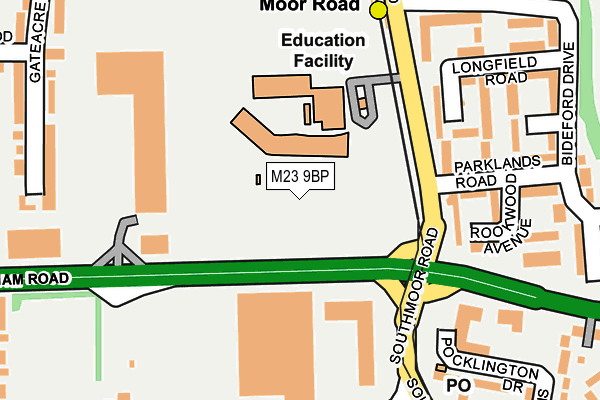
M23 9BP is located in the Brooklands electoral ward, within the metropolitan district of Manchester and the English Parliamentary constituency of Wythenshawe and Sale East. The Sub Integrated Care Board (ICB) Location is NHS Greater Manchester ICB - 14L and the police force is Greater Manchester. This postcode has been in use since January 1980.


GetTheData
Source: OS OpenMap – Local (Ordnance Survey)
Source: OS VectorMap District (Ordnance Survey)
Licence: Open Government Licence (requires attribution)
| Easting | 380397 |
| Northing | 389518 |
| Latitude | 53.402132 |
| Longitude | -2.296305 |
GetTheData
Source: Open Postcode Geo
Licence: Open Government Licence
| Country | England |
| Postcode District | M23 |
➜ See where M23 is on a map ➜ Where is Wythenshawe? | |
GetTheData
Source: Land Registry Price Paid Data
Licence: Open Government Licence
Elevation or altitude of M23 9BP as distance above sea level:
| Metres | Feet | |
|---|---|---|
| Elevation | 30m | 98ft |
Elevation is measured from the approximate centre of the postcode, to the nearest point on an OS contour line from OS Terrain 50, which has contour spacing of ten vertical metres.
➜ How high above sea level am I? Find the elevation of your current position using your device's GPS.
GetTheData
Source: Open Postcode Elevation
Licence: Open Government Licence
| Ward | Brooklands |
| Constituency | Wythenshawe And Sale East |
GetTheData
Source: ONS Postcode Database
Licence: Open Government Licence
| Moor Rd/Brookway H.s. (Moor Rd) | Baguley | 119m |
| Moor Rd Metrolink Stop (Moor Rd) | Baguley | 125m |
| Altrincham Rd/Baguley Tesco (Altrincham Rd) | Baguley | 145m |
| Moor Rd Metrolink Stop (Moor Rd) | Baguley | 169m |
| Southmoor Rd/Altrincham Rd (Southmoor Rd) | Baguley | 233m |
| Moor Road (Manchester Metrolink) (Moor Road) | Baguley | 161m |
| Wythenshawe Park (Manchester Metrolink) (Wythenshawe Road) | Northern Moor | 618m |
| Baguley (Manchester Metrolink) (Southmoor Road) | Baguley | 672m |
| Roundthorn (Manchester Metrolink) (Southmoor Road) | Roundthorn | 1,162m |
| Northern Moor (Manchester Metrolink) (Sale Road) | Northern Moor | 1,480m |
| Navigation Road Station | 3.2km |
| Altrincham Station | 3.7km |
| Hale Station | 4.3km |
GetTheData
Source: NaPTAN
Licence: Open Government Licence
GetTheData
Source: ONS Postcode Database
Licence: Open Government Licence


➜ Get more ratings from the Food Standards Agency
GetTheData
Source: Food Standards Agency
Licence: FSA terms & conditions
| Last Collection | |||
|---|---|---|---|
| Location | Mon-Fri | Sat | Distance |
| Parklands Road | 17:30 | 12:00 | 264m |
| Royal Oak P.o. | 17:30 | 12:00 | 268m |
| 382 Wythenshawe Road | 17:30 | 12:00 | 554m |
GetTheData
Source: Dracos
Licence: Creative Commons Attribution-ShareAlike
The below table lists the International Territorial Level (ITL) codes (formerly Nomenclature of Territorial Units for Statistics (NUTS) codes) and Local Administrative Units (LAU) codes for M23 9BP:
| ITL 1 Code | Name |
|---|---|
| TLD | North West (England) |
| ITL 2 Code | Name |
| TLD3 | Greater Manchester |
| ITL 3 Code | Name |
| TLD33 | Manchester |
| LAU 1 Code | Name |
| E08000003 | Manchester |
GetTheData
Source: ONS Postcode Directory
Licence: Open Government Licence
The below table lists the Census Output Area (OA), Lower Layer Super Output Area (LSOA), and Middle Layer Super Output Area (MSOA) for M23 9BP:
| Code | Name | |
|---|---|---|
| OA | E00025884 | |
| LSOA | E01005117 | Manchester 048E |
| MSOA | E02001092 | Manchester 048 |
GetTheData
Source: ONS Postcode Directory
Licence: Open Government Licence
| M23 0GH | Longfield Road | 173m |
| M23 0GB | Parklands Road | 182m |
| M23 0GJ | Rookwood Avenue | 206m |
| M23 0QJ | Lulworth Gardens | 213m |
| M23 0GA | Farcroft Close | 241m |
| M23 9RY | Lawnhurst Avenue | 250m |
| M23 1ED | Pocklington Drive | 255m |
| M23 9BA | Gateacre Walk | 269m |
| M23 0QH | Bideford Drive | 286m |
| M23 9SB | Lawnhurst Avenue | 321m |
GetTheData
Source: Open Postcode Geo; Land Registry Price Paid Data
Licence: Open Government Licence