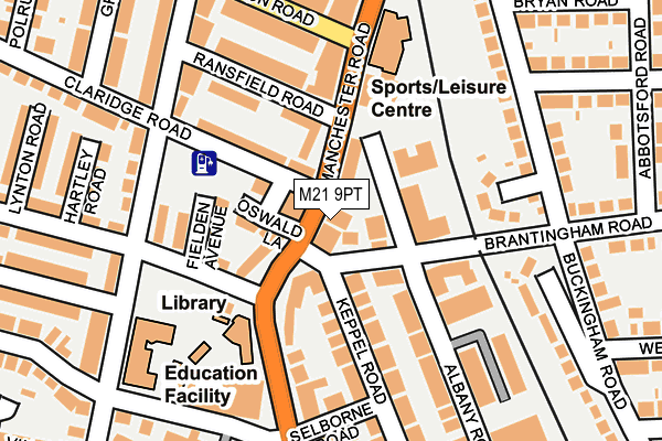
M21 9PT is located in the Chorlton electoral ward, within the metropolitan district of Manchester and the English Parliamentary constituency of Manchester, Withington. The Sub Integrated Care Board (ICB) Location is NHS Greater Manchester ICB - 14L and the police force is Greater Manchester. This postcode has been in use since May 1994.


GetTheData
Source: OS OpenMap – Local (Ordnance Survey)
Source: OS VectorMap District (Ordnance Survey)
Licence: Open Government Licence (requires attribution)
| Easting | 381653 |
| Northing | 394351 |
| Latitude | 53.445603 |
| Longitude | -2.277697 |
GetTheData
Source: Open Postcode Geo
Licence: Open Government Licence
| Country | England |
| Postcode District | M21 |
➜ See where M21 is on a map ➜ Where is Manchester? | |
GetTheData
Source: Land Registry Price Paid Data
Licence: Open Government Licence
Elevation or altitude of M21 9PT as distance above sea level:
| Metres | Feet | |
|---|---|---|
| Elevation | 30m | 98ft |
Elevation is measured from the approximate centre of the postcode, to the nearest point on an OS contour line from OS Terrain 50, which has contour spacing of ten vertical metres.
➜ How high above sea level am I? Find the elevation of your current position using your device's GPS.
GetTheData
Source: Open Postcode Elevation
Licence: Open Government Licence
| Ward | Chorlton |
| Constituency | Manchester, Withington |
GetTheData
Source: ONS Postcode Database
Licence: Open Government Licence
| Manchester Rd/Kensington Rd (Manchester Rd) | Chorlton | 52m |
| Manchester Rd/Chorlton Library (Manchester Rd) | Chorlton | 75m |
| Manchester Rd/Kensington Rd (Manchester Rd) | Whalley Range | 198m |
| Barlow Moor Rd/Nicolas Rd (Barlow Moor Rd) | Chorlton | 248m |
| Barlow Moor Rd/Wilbraham Rd (Barlow Moor Rd) | Chorlton | 303m |
| Chorlton (Manchester Metrolink) (Wilbraham Road) | Chorlton | 435m |
| Firswood Station (Manchester Metrolink) (Rye Bank Road) | Firswood | 631m |
| St Werburgh's Road (Manchester Metrolink) (St Werburgh's Road) | Chorlton | 1,118m |
| Old Trafford (Manchester Metrolink) (Trafford Park Road) | Old Trafford | 1,288m |
| Barlow Moor Road (Manchester Metrolink) (Mauldeth Road) | Chorltonville | 1,527m |
| Manchester United FC Station | 2km |
| Trafford Park Station | 2.4km |
| Humphrey Park Station | 3.4km |
GetTheData
Source: NaPTAN
Licence: Open Government Licence
GetTheData
Source: ONS Postcode Database
Licence: Open Government Licence


➜ Get more ratings from the Food Standards Agency
GetTheData
Source: Food Standards Agency
Licence: FSA terms & conditions
| Last Collection | |||
|---|---|---|---|
| Location | Mon-Fri | Sat | Distance |
| 70 Manchester Road | 17:30 | 12:00 | 38m |
| M/S Funeral Dept. Opp 32 | 17:30 | 12:00 | 196m |
| Oswald Road | 17:30 | 12:00 | 208m |
GetTheData
Source: Dracos
Licence: Creative Commons Attribution-ShareAlike
The below table lists the International Territorial Level (ITL) codes (formerly Nomenclature of Territorial Units for Statistics (NUTS) codes) and Local Administrative Units (LAU) codes for M21 9PT:
| ITL 1 Code | Name |
|---|---|
| TLD | North West (England) |
| ITL 2 Code | Name |
| TLD3 | Greater Manchester |
| ITL 3 Code | Name |
| TLD33 | Manchester |
| LAU 1 Code | Name |
| E08000003 | Manchester |
GetTheData
Source: ONS Postcode Directory
Licence: Open Government Licence
The below table lists the Census Output Area (OA), Lower Layer Super Output Area (LSOA), and Middle Layer Super Output Area (MSOA) for M21 9PT:
| Code | Name | |
|---|---|---|
| OA | E00026100 | |
| LSOA | E01005159 | Manchester 029D |
| MSOA | E02001073 | Manchester 029 |
GetTheData
Source: ONS Postcode Directory
Licence: Open Government Licence
| M21 9PQ | Manchester Road | 23m |
| M21 0BN | Albany Road | 41m |
| M21 9PW | Manchester Road | 53m |
| M21 9GF | Redgates Walk | 65m |
| M21 0BJ | Brantingham Road | 72m |
| M21 9QA | Oswald Lane | 77m |
| M21 0BA | Albany Road | 78m |
| M21 9QB | Fielden Avenue | 103m |
| M21 9GG | Ransfield Road | 105m |
| M21 9PL | Longford Road | 108m |
GetTheData
Source: Open Postcode Geo; Land Registry Price Paid Data
Licence: Open Government Licence