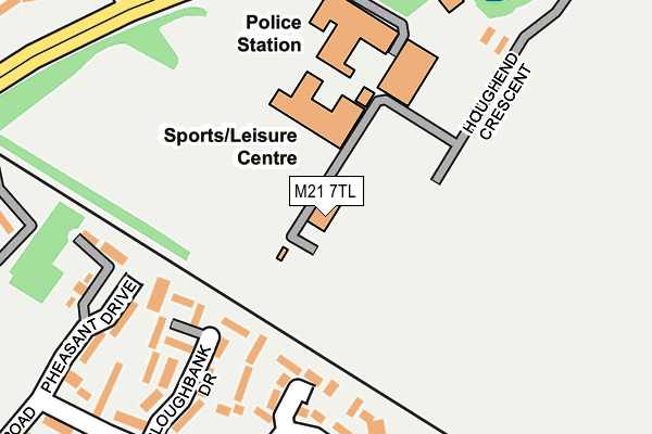
M21 7TL is located in the Chorlton Park electoral ward, within the metropolitan district of Manchester and the English Parliamentary constituency of Manchester, Withington. The Sub Integrated Care Board (ICB) Location is NHS Greater Manchester ICB - 14L and the police force is Greater Manchester. This postcode has been in use since March 2006.


GetTheData
Source: OS OpenMap – Local (Ordnance Survey)
Source: OS VectorMap District (Ordnance Survey)
Licence: Open Government Licence (requires attribution)
| Easting | 383251 |
| Northing | 393483 |
| Latitude | 53.437871 |
| Longitude | -2.253591 |
GetTheData
Source: Open Postcode Geo
Licence: Open Government Licence
| Country | England |
| Postcode District | M21 |
➜ See where M21 is on a map ➜ Where is Manchester? | |
GetTheData
Source: Land Registry Price Paid Data
Licence: Open Government Licence
Elevation or altitude of M21 7TL as distance above sea level:
| Metres | Feet | |
|---|---|---|
| Elevation | 30m | 98ft |
Elevation is measured from the approximate centre of the postcode, to the nearest point on an OS contour line from OS Terrain 50, which has contour spacing of ten vertical metres.
➜ How high above sea level am I? Find the elevation of your current position using your device's GPS.
GetTheData
Source: Open Postcode Elevation
Licence: Open Government Licence
| Ward | Chorlton Park |
| Constituency | Manchester, Withington |
GetTheData
Source: ONS Postcode Database
Licence: Open Government Licence
| Mauldeth Rd West/Hough End Ctr (Mauldeth Rd Wst) | Chorlton | 121m |
| Mauldeth Rd West/Hough End Ctr (Mauldeth Rd Wst) | Chorlton | 153m |
| Mauldeth Rd West/Alexandra Rd South (Mauldeth Rd Wst) | Chorlton | 270m |
| Mauldeth Rd/Alexandra Rd South (Mauldeth Rd Wst) | Chorlton | 298m |
| Mauldeth Rd West/Withington Rd (Mauldeth Rd Wst) | Chorlton | 360m |
| Withington (Manchester Metrolink) (Princess Road) | Withington | 628m |
| St Werburgh's Road (Manchester Metrolink) (St Werburgh's Road) | Chorlton | 793m |
| Barlow Moor Road (Manchester Metrolink) (Mauldeth Road) | Chorltonville | 1,188m |
| Burton Road (Manchester Metrolink) (Burton Road) | West Didsbury | 1,290m |
| Chorlton (Manchester Metrolink) (Wilbraham Road) | Chorlton | 1,419m |
| Mauldeth Road Station | 3km |
| Burnage Station | 3.1km |
| Manchester United FC Station | 3.7km |
GetTheData
Source: NaPTAN
Licence: Open Government Licence
GetTheData
Source: ONS Postcode Database
Licence: Open Government Licence


➜ Get more ratings from the Food Standards Agency
GetTheData
Source: Food Standards Agency
Licence: FSA terms & conditions
| Last Collection | |||
|---|---|---|---|
| Location | Mon-Fri | Sat | Distance |
| 34 Wintermans Road | 17:30 | 11:45 | 511m |
| 102 Alexandra Road South | 17:30 | 11:45 | 609m |
| Moorgate Avenue | 17:30 | 12:00 | 648m |
GetTheData
Source: Dracos
Licence: Creative Commons Attribution-ShareAlike
| Risk of M21 7TL flooding from rivers and sea | Low |
| ➜ M21 7TL flood map | |
GetTheData
Source: Open Flood Risk by Postcode
Licence: Open Government Licence
The below table lists the International Territorial Level (ITL) codes (formerly Nomenclature of Territorial Units for Statistics (NUTS) codes) and Local Administrative Units (LAU) codes for M21 7TL:
| ITL 1 Code | Name |
|---|---|
| TLD | North West (England) |
| ITL 2 Code | Name |
| TLD3 | Greater Manchester |
| ITL 3 Code | Name |
| TLD33 | Manchester |
| LAU 1 Code | Name |
| E08000003 | Manchester |
GetTheData
Source: ONS Postcode Directory
Licence: Open Government Licence
The below table lists the Census Output Area (OA), Lower Layer Super Output Area (LSOA), and Middle Layer Super Output Area (MSOA) for M21 7TL:
| Code | Name | |
|---|---|---|
| OA | E00175882 | |
| LSOA | E01005279 | Manchester 035E |
| MSOA | E02001079 | Manchester 035 |
GetTheData
Source: ONS Postcode Directory
Licence: Open Government Licence
| M21 7RB | Mauldeth Road West | 163m |
| M21 7RA | Mauldeth Road West | 228m |
| M21 7TD | Alexandra Road South | 241m |
| M16 8NW | Caistor Close | 253m |
| M21 7RF | Mauldeth Road West | 322m |
| M21 7RH | Batchelor Close | 368m |
| M16 8WS | Holwood Drive | 368m |
| M21 7UE | Blanefield Close | 370m |
| M21 0YA | Withington Road | 371m |
| M16 8NN | Shuttleworth Close | 381m |
GetTheData
Source: Open Postcode Geo; Land Registry Price Paid Data
Licence: Open Government Licence