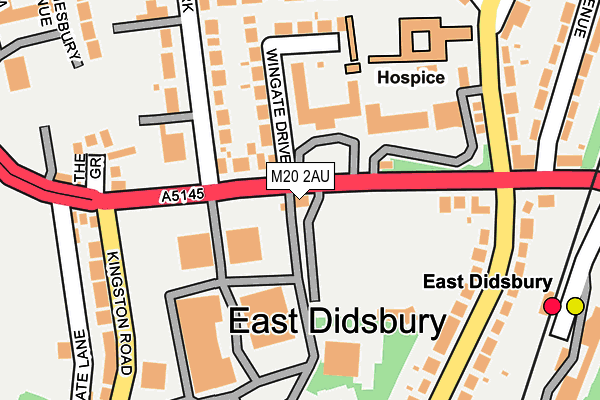
M20 2AU is located in the Didsbury East electoral ward, within the metropolitan district of Manchester and the English Parliamentary constituency of Manchester, Withington. The Sub Integrated Care Board (ICB) Location is NHS Greater Manchester ICB - 14L and the police force is Greater Manchester. This postcode has been in use since December 2016.


GetTheData
Source: OS OpenMap – Local (Ordnance Survey)
Source: OS VectorMap District (Ordnance Survey)
Licence: Open Government Licence (requires attribution)
| Easting | 385086 |
| Northing | 390404 |
| Latitude | 53.410250 |
| Longitude | -2.225821 |
GetTheData
Source: Open Postcode Geo
Licence: Open Government Licence
| Country | England |
| Postcode District | M20 |
➜ See where M20 is on a map ➜ Where is Manchester? | |
GetTheData
Source: Land Registry Price Paid Data
Licence: Open Government Licence
Elevation or altitude of M20 2AU as distance above sea level:
| Metres | Feet | |
|---|---|---|
| Elevation | 40m | 131ft |
Elevation is measured from the approximate centre of the postcode, to the nearest point on an OS contour line from OS Terrain 50, which has contour spacing of ten vertical metres.
➜ How high above sea level am I? Find the elevation of your current position using your device's GPS.
GetTheData
Source: Open Postcode Elevation
Licence: Open Government Licence
| Ward | Didsbury East |
| Constituency | Manchester, Withington |
GetTheData
Source: ONS Postcode Database
Licence: Open Government Licence
| Wilmslow Rd/Didsbury Cricket Club (Wilmslow Rd) | East Didsbury | 88m |
| Wilmslow Rd/Didsbury Cricket Club (Wilmslow Rd) | East Didsbury | 99m |
| Parrs Wood Rd/Wilmslow Rd (Parrs Wood Rd) | East Didsbury | 198m |
| Parrs Wood Rd/Wilmslow Rd (Parrs Wood Rd) | East Didsbury | 213m |
| Wilmslow Rd/Fletcher Moss (Wilmslow Rd) | Didsbury | 219m |
| East Didsbury (Manchester Metrolink) (Kingsway) | East Didsbury | 604m |
| Didsbury Village (Manchester Metrolink) (Olive Shapley Avenue) | Didsbury | 745m |
| East Didsbury Station | 0.3km |
| Burnage Station | 1.4km |
| Gatley Station | 2km |
GetTheData
Source: NaPTAN
Licence: Open Government Licence
GetTheData
Source: ONS Postcode Database
Licence: Open Government Licence


➜ Get more ratings from the Food Standards Agency
GetTheData
Source: Food Standards Agency
Licence: FSA terms & conditions
| Last Collection | |||
|---|---|---|---|
| Location | Mon-Fri | Sat | Distance |
| Didsbury Park | 17:30 | 12:00 | 108m |
| Parrs Wood P.o. | 17:30 | 12:00 | 269m |
| Didsbury Collage | 17:30 | 12:00 | 326m |
GetTheData
Source: Dracos
Licence: Creative Commons Attribution-ShareAlike
The below table lists the International Territorial Level (ITL) codes (formerly Nomenclature of Territorial Units for Statistics (NUTS) codes) and Local Administrative Units (LAU) codes for M20 2AU:
| ITL 1 Code | Name |
|---|---|
| TLD | North West (England) |
| ITL 2 Code | Name |
| TLD3 | Greater Manchester |
| ITL 3 Code | Name |
| TLD33 | Manchester |
| LAU 1 Code | Name |
| E08000003 | Manchester |
GetTheData
Source: ONS Postcode Directory
Licence: Open Government Licence
The below table lists the Census Output Area (OA), Lower Layer Super Output Area (LSOA), and Middle Layer Super Output Area (MSOA) for M20 2AU:
| Code | Name | |
|---|---|---|
| OA | E00026204 | |
| LSOA | E01005169 | Manchester 045C |
| MSOA | E02001089 | Manchester 045 |
GetTheData
Source: ONS Postcode Directory
Licence: Open Government Licence
| M20 2RT | Wingate Drive | 150m |
| M20 5QP | Wilmslow Road | 158m |
| M20 2SN | Wilmslow Road | 166m |
| M20 5LJ | Didsbury Park | 198m |
| M20 5GT | Parrs Wood Road | 202m |
| M20 5LH | Didsbury Park | 208m |
| M20 5GP | Parrs Wood Road | 208m |
| M20 5LW | Ruabon Road | 209m |
| M20 2RG | The Grove | 216m |
| M20 2RZ | Kingston Road | 219m |
GetTheData
Source: Open Postcode Geo; Land Registry Price Paid Data
Licence: Open Government Licence