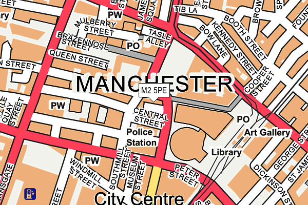
M2 5PE lies on Albert Square in Manchester. M2 5PE is located in the Deansgate electoral ward, within the metropolitan district of Manchester and the English Parliamentary constituency of Manchester Central. The Sub Integrated Care Board (ICB) Location is NHS Greater Manchester ICB - 14L and the police force is Greater Manchester. This postcode has been in use since January 1980.


GetTheData
Source: OS OpenMap – Local (Ordnance Survey)
Source: OS VectorMap District (Ordnance Survey)
Licence: Open Government Licence (requires attribution)
| Easting | 383794 |
| Northing | 398042 |
| Latitude | 53.478849 |
| Longitude | -2.245654 |
GetTheData
Source: Open Postcode Geo
Licence: Open Government Licence
| Street | Albert Square |
| Town/City | Manchester |
| Country | England |
| Postcode District | M2 |
➜ See where M2 is on a map ➜ Where is Manchester? | |
GetTheData
Source: Land Registry Price Paid Data
Licence: Open Government Licence
Elevation or altitude of M2 5PE as distance above sea level:
| Metres | Feet | |
|---|---|---|
| Elevation | 40m | 131ft |
Elevation is measured from the approximate centre of the postcode, to the nearest point on an OS contour line from OS Terrain 50, which has contour spacing of ten vertical metres.
➜ How high above sea level am I? Find the elevation of your current position using your device's GPS.
GetTheData
Source: Open Postcode Elevation
Licence: Open Government Licence
| Ward | Deansgate |
| Constituency | Manchester Central |
GetTheData
Source: ONS Postcode Database
Licence: Open Government Licence
| Albert Square | Albert Square | 49m |
| Albert Square | Albert Square | 67m |
| Peter St/Mount St (Peter St) | Manchester City Centre | 111m |
| Princess St/Town Hall (Princess St) | Albert Square | 146m |
| Peter St/Edwardian Hotel (Peter St) | Manchester City Centre | 150m |
| St Peters Square (Manchester Metrolink) (Peter Street) | Manchester City Centre | 183m |
| Market Street (Manchester Metrolink) (Market Street) | Manchester City Centre | 552m |
| Deansgate-castlefield (Manchester Metrolink) (Whitworth Street West) | Manchester City Centre | 591m |
| Piccadilly Gardens (Manchester Metrolink) (Portland Street) | Piccadilly Gardens | 619m |
| Exchange Square (Manchester Metrolink) (Corporation St) | Manchester City Centre | 653m |
| Manchester Oxford Road Station | 0.6km |
| Deansgate Station | 0.6km |
| Salford Central Station | 0.8km |
GetTheData
Source: NaPTAN
Licence: Open Government Licence
Estimated total energy consumption in M2 5PE by fuel type, 2015.
| Consumption (kWh) | 119,783 |
|---|---|
| Meter count | 6 |
| Mean (kWh/meter) | 19,964 |
| Median (kWh/meter) | 11,950 |
GetTheData
Source: Postcode level gas estimates: 2015 (experimental)
Source: Postcode level electricity estimates: 2015 (experimental)
Licence: Open Government Licence
GetTheData
Source: ONS Postcode Database
Licence: Open Government Licence


➜ Get more ratings from the Food Standards Agency
GetTheData
Source: Food Standards Agency
Licence: FSA terms & conditions
| Last Collection | |||
|---|---|---|---|
| Location | Mon-Fri | Sat | Distance |
| 12 Albert Square/Lloyd Street | 19:00 | 12:00 | 36m |
| Mount Street | 19:00 | 12:00 | 134m |
| Brazennose P.o. | 19:00 | 12:00 | 140m |
GetTheData
Source: Dracos
Licence: Creative Commons Attribution-ShareAlike
The below table lists the International Territorial Level (ITL) codes (formerly Nomenclature of Territorial Units for Statistics (NUTS) codes) and Local Administrative Units (LAU) codes for M2 5PE:
| ITL 1 Code | Name |
|---|---|
| TLD | North West (England) |
| ITL 2 Code | Name |
| TLD3 | Greater Manchester |
| ITL 3 Code | Name |
| TLD33 | Manchester |
| LAU 1 Code | Name |
| E08000003 | Manchester |
GetTheData
Source: ONS Postcode Directory
Licence: Open Government Licence
The below table lists the Census Output Area (OA), Lower Layer Super Output Area (LSOA), and Middle Layer Super Output Area (MSOA) for M2 5PE:
| Code | Name | |
|---|---|---|
| OA | E00175962 | |
| LSOA | E01033677 | Manchester 060A |
| MSOA | E02006917 | Manchester 060 |
GetTheData
Source: ONS Postcode Directory
Licence: Open Government Licence
| M2 5WR | Central Street | 30m |
| M60 2WH | Gillbrook Road | 87m |
| M2 5GB | Peter Street | 110m |
| M2 3NQ | Peter Street | 147m |
| M2 6LE | John Dalton Street | 148m |
| M2 4JW | Cross Street | 154m |
| M2 4FN | Princess Street | 156m |
| M2 4BY | Booth Street | 175m |
| M2 4JN | Cross Street | 181m |
| M2 4JB | Tib Lane | 189m |
GetTheData
Source: Open Postcode Geo; Land Registry Price Paid Data
Licence: Open Government Licence