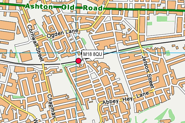
M18 8QU lies on Enterprise Trading Estate in Abbey Hey, Manchester. M18 8QU is located in the Gorton & Abbey Hey electoral ward, within the metropolitan district of Manchester and the English Parliamentary constituency of Manchester, Gorton. The Sub Integrated Care Board (ICB) Location is NHS Greater Manchester ICB - 14L and the police force is Greater Manchester. This postcode has been in use since May 1994.


GetTheData
Source: OS OpenMap – Local (Ordnance Survey)
Source: OS VectorMap District (Ordnance Survey)
Licence: Open Government Licence (requires attribution)
| Easting | 389134 |
| Northing | 396928 |
| Latitude | 53.468975 |
| Longitude | -2.165154 |
GetTheData
Source: Open Postcode Geo
Licence: Open Government Licence
| Street | Enterprise Trading Estate |
| Locality | Abbey Hey |
| Town/City | Manchester |
| Country | England |
| Postcode District | M18 |
➜ See where M18 is on a map ➜ Where is Manchester? | |
GetTheData
Source: Land Registry Price Paid Data
Licence: Open Government Licence
Elevation or altitude of M18 8QU as distance above sea level:
| Metres | Feet | |
|---|---|---|
| Elevation | 70m | 230ft |
Elevation is measured from the approximate centre of the postcode, to the nearest point on an OS contour line from OS Terrain 50, which has contour spacing of ten vertical metres.
➜ How high above sea level am I? Find the elevation of your current position using your device's GPS.
GetTheData
Source: Open Postcode Elevation
Licence: Open Government Licence
| Ward | Gorton & Abbey Hey |
| Constituency | Manchester, Gorton |
GetTheData
Source: ONS Postcode Database
Licence: Open Government Licence
| Ogden Ln/Lees St (Ogden Ln) | Higher Openshaw | 270m |
| Ogden Ln/Lees St (Ogden Ln) | Higher Openshaw | 280m |
| Abbey Hey Ln/Lees St (Abbey Hey Ln) | Abbey Hey | 330m |
| Abbey Hey Ln/Lees St (Abbey Hey Ln) | Abbey Hey | 358m |
| Chapman St/Reed St (Chapman St) | Gorton | 397m |
| Edge Lane (Manchester Metrolink) (Manchester Road) | Droylsden | 1,321m |
| Cemetery Road (Manchester Metrolink) (Manchester Road) | Droylsden | 1,384m |
| Droylsden (Manchester Metrolink) (Ashton Road) | Droylsden | 1,790m |
| Gorton Station | 0.1km |
| Belle Vue Station | 1.3km |
| Fairfield Station | 1.3km |
GetTheData
Source: NaPTAN
Licence: Open Government Licence
GetTheData
Source: ONS Postcode Database
Licence: Open Government Licence


➜ Get more ratings from the Food Standards Agency
GetTheData
Source: Food Standards Agency
Licence: FSA terms & conditions
| Last Collection | |||
|---|---|---|---|
| Location | Mon-Fri | Sat | Distance |
| Constable Street | 17:30 | 12:00 | 147m |
| 428 Abbey Hey Lane | 17:30 | 12:00 | 323m |
| Station | 17:30 | 12:00 | 381m |
GetTheData
Source: Dracos
Licence: Creative Commons Attribution-ShareAlike
The below table lists the International Territorial Level (ITL) codes (formerly Nomenclature of Territorial Units for Statistics (NUTS) codes) and Local Administrative Units (LAU) codes for M18 8QU:
| ITL 1 Code | Name |
|---|---|
| TLD | North West (England) |
| ITL 2 Code | Name |
| TLD3 | Greater Manchester |
| ITL 3 Code | Name |
| TLD33 | Manchester |
| LAU 1 Code | Name |
| E08000003 | Manchester |
GetTheData
Source: ONS Postcode Directory
Licence: Open Government Licence
The below table lists the Census Output Area (OA), Lower Layer Super Output Area (LSOA), and Middle Layer Super Output Area (MSOA) for M18 8QU:
| Code | Name | |
|---|---|---|
| OA | E00026274 | |
| LSOA | E01005188 | Manchester 021B |
| MSOA | E02001065 | Manchester 021 |
GetTheData
Source: ONS Postcode Directory
Licence: Open Government Licence
| M18 8QL | Lees Street | 78m |
| M18 8GY | Constable Street | 89m |
| M11 1NR | Rushton Grove | 98m |
| M11 1NX | Lees Street | 103m |
| M11 1WW | Evenley Close | 124m |
| M18 8QR | Annable Road | 125m |
| M18 8GN | Brightman Street | 136m |
| M18 8QQ | Constable Street | 137m |
| M11 1WU | Alvan Square | 143m |
| M18 8GW | Welbeck Street | 147m |
GetTheData
Source: Open Postcode Geo; Land Registry Price Paid Data
Licence: Open Government Licence