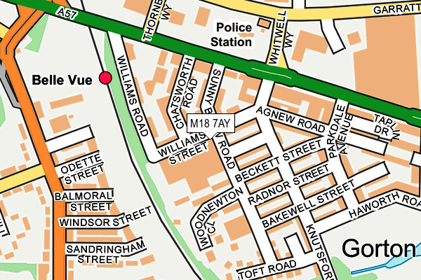
M18 7AY is located in the Gorton & Abbey Hey electoral ward, within the metropolitan district of Manchester and the English Parliamentary constituency of Manchester, Gorton. The Sub Integrated Care Board (ICB) Location is NHS Greater Manchester ICB - 14L and the police force is Greater Manchester. This postcode has been in use since May 1994.


GetTheData
Source: OS OpenMap – Local (Ordnance Survey)
Source: OS VectorMap District (Ordnance Survey)
Licence: Open Government Licence (requires attribution)
| Easting | 388263 |
| Northing | 396001 |
| Latitude | 53.460640 |
| Longitude | -2.178239 |
GetTheData
Source: Open Postcode Geo
Licence: Open Government Licence
| Country | England |
| Postcode District | M18 |
➜ See where M18 is on a map ➜ Where is Manchester? | |
GetTheData
Source: Land Registry Price Paid Data
Licence: Open Government Licence
Elevation or altitude of M18 7AY as distance above sea level:
| Metres | Feet | |
|---|---|---|
| Elevation | 60m | 197ft |
Elevation is measured from the approximate centre of the postcode, to the nearest point on an OS contour line from OS Terrain 50, which has contour spacing of ten vertical metres.
➜ How high above sea level am I? Find the elevation of your current position using your device's GPS.
GetTheData
Source: Open Postcode Elevation
Licence: Open Government Licence
| Ward | Gorton & Abbey Hey |
| Constituency | Manchester, Gorton |
GetTheData
Source: ONS Postcode Database
Licence: Open Government Licence
| Knutsford Rd/Beckett St (Knutsford Rd) | Gorton | 126m |
| Knutsford Rd/Radnor St (Knutsford Rd) | Gorton | 127m |
| Hyde Rd/Sunny Brow Rd (Hyde Rd) | Belle Vue | 146m |
| Hyde Rd/Chatsworth Rd (Hyde Rd) | Belle Vue | 158m |
| Hyde Road | Belle Vue | 158m |
| Belle Vue Station | 0.2km |
| Ryder Brow Station | 0.6km |
| Gorton Station | 1.2km |
GetTheData
Source: NaPTAN
Licence: Open Government Licence
GetTheData
Source: ONS Postcode Database
Licence: Open Government Licence


➜ Get more ratings from the Food Standards Agency
GetTheData
Source: Food Standards Agency
Licence: FSA terms & conditions
| Last Collection | |||
|---|---|---|---|
| Location | Mon-Fri | Sat | Distance |
| Parkdale Avenue | 17:30 | 12:00 | 221m |
| Hampden Cresent | 17:30 | 12:00 | 259m |
| Brookhurst Road | 17:30 | 12:00 | 447m |
GetTheData
Source: Dracos
Licence: Creative Commons Attribution-ShareAlike
The below table lists the International Territorial Level (ITL) codes (formerly Nomenclature of Territorial Units for Statistics (NUTS) codes) and Local Administrative Units (LAU) codes for M18 7AY:
| ITL 1 Code | Name |
|---|---|
| TLD | North West (England) |
| ITL 2 Code | Name |
| TLD3 | Greater Manchester |
| ITL 3 Code | Name |
| TLD33 | Manchester |
| LAU 1 Code | Name |
| E08000003 | Manchester |
GetTheData
Source: ONS Postcode Directory
Licence: Open Government Licence
The below table lists the Census Output Area (OA), Lower Layer Super Output Area (LSOA), and Middle Layer Super Output Area (MSOA) for M18 7AY:
| Code | Name | |
|---|---|---|
| OA | E00026307 | |
| LSOA | E01005201 | Manchester 023E |
| MSOA | E02001067 | Manchester 023 |
GetTheData
Source: ONS Postcode Directory
Licence: Open Government Licence
| M18 7AH | Williams Street | 56m |
| M18 7AZ | Sunny Brow Road | 75m |
| M18 7AN | Bragenham Street | 81m |
| M18 7AJ | Woodnewton Close | 84m |
| M18 7AF | Chatsworth Road | 86m |
| M18 7AE | Sunny Brow Road | 87m |
| M18 7AW | Beckett Street | 90m |
| M18 7AP | Radnor Street | 124m |
| M18 7AL | Knutsford Road | 129m |
| M18 7QH | Glencastle Road | 135m |
GetTheData
Source: Open Postcode Geo; Land Registry Price Paid Data
Licence: Open Government Licence